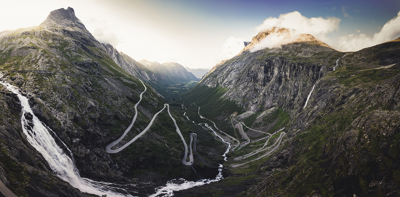
Trollstigen
The name means "the troll's path," and from the air, it looks like something only a troll would attempt. Eleven hairpin bends climb a 10-percent grade up a sheer mountainside in More og Romsdal county, western Norway, each switchback tighter than the last, the road narrowing as it rises. Beside it, the Stigfossen waterfall drops 320 meters in a single plunge, close enough to mist the windshields of passing cars. Trollstigen is not the fastest way between Andalsnes and Valldal -- it is the most dramatic, and that has been the point since King Haakon VII stood at the summit on July 31, 1936, and declared the road open after eight years of construction through some of the most unforgiving terrain in Scandinavia.
Eight Years of Dynamite and Determination
Construction on Trollstigen began in 1928, during a period when Norway was aggressively building roads into its mountainous interior. The challenge here was exceptional. The route needed to climb from the valley floor to an 850-meter plateau through rock faces that offered no natural gradient. Engineers designed a series of eleven hairpin bends, each blasted and chiseled from the mountainside. Workers labored through short summer seasons, battling rockfalls, avalanches, and weather that could shift from clear to whiteout within hours. The road became part of Norwegian County Road 63, connecting the town of Andalsnes in Rauma Municipality to the village of Valldal in Fjord Municipality. When Haakon VII signed the acceptance document at the summit, it marked the completion of one of Norway's most ambitious civil engineering projects -- a road that was as much a statement of national will as it was a transportation link.
The Waterfall and the Viewing Platform
At the 700-meter plateau, the road levels out at a car park with several viewing balconies cantilevered over the mountainside. The view is vertiginous: the hairpin bends unfold below like a zipper, and Stigfossen crashes past in a roar of white water that seems close enough to touch. The waterfall's total drop of 320 meters makes it one of Norway's tallest, and its proximity to the road -- the spray sometimes reaches passing vehicles -- gives Trollstigen a theatrical quality that few mountain passes can match. A major visitor center and restaurant were completed in 2012, the same year the road was officially designated a National Tourist Route. During peak summer months, roughly 2,500 vehicles a day wind their way up or down the pass, creating traffic jams that would seem absurd anywhere else but feel oddly festive here, at the top of a mountain, with a waterfall thundering alongside.
A Road That Closes Itself
Trollstigen typically opens in mid-May and closes in October, though the exact dates depend entirely on the mountain's mood. Heavy snowfall, avalanche risk, and rockfall can shorten the season from either end. In the summer of 2005, 16 million Norwegian kroner was spent on rockfall protection and road widening -- several hairpin bends were expanded, though vehicles longer than 12.4 meters are still prohibited. The road closure is not a failure of infrastructure but an acknowledgment of terrain. The alpine area east of Trollstigen, including the Trolltindene range, is part of Reinheimen National Park, and the road itself lies within the Trollstigen landscape protection area. In winter, the pass belongs to snow and silence. The viewing platforms stand empty, the waterfall freezes into blue columns of ice, and the hairpin bends vanish under meters of white.
Trolls and Telecommunications
The etymology is straightforward: Trollstigen derives from the Norwegian stig, meaning path or trail, from Old Norse stigr. The trolls in question are the mythical giants of Norse folklore, creatures of mountain and shadow who turned to stone in sunlight. The nearby Trolltindene peaks and the famous Trollveggen -- Europe's tallest vertical rock face -- reinforce the naming convention; this is troll country, where the scale of the landscape invites mythological explanation. In a delightful contrast, Trollstigen received mobile phone coverage for the first time in June 2021, when Telia Norge installed an eco-friendly base station powered entirely by solar panels, wind turbines, and hydrogen fuel cells. The trolls' path entered the 21st century, though the trolls themselves, presumably, remain unimpressed.
From the Air
Trollstigen is located at 62.46N, 7.67E in Rauma Municipality, western Norway. From the air, the eleven hairpin bends are clearly visible as a zigzag pattern carved into the steep mountainside. Stigfossen waterfall (320m) falls beside the road. The visitor center and car park are visible at the 700m plateau. The Trolltindene peaks and Trollveggen (Europe's tallest vertical rock face) are nearby to the northeast. The road connects Andalsnes (northwest) to Valldal (south). Nearest airport: Molde Airport, Aro (ENML), approximately 65 km northwest. Altitude recommendation: 3,000-5,000 ft for the best view of the hairpin bends against the mountain. The road is closed and snow-covered from October to May.