Ts'ehlanyane National Park
The park is named after a plant that is disappearing. Ts'ehlanyane - the local Sesotho name for berg bamboo, Thamnocalamus tessellatus - clings to the riverbanks and damp slopes of northern Lesotho's Maloti Mountains, growing three meters tall in dense stands that rustle in the alpine wind. This bamboo, endemic to the Drakensberg range, is endangered in neighboring South Africa, and Ts'ehlanyane National Park may be its most important remaining refuge. That the park exists at all is an accident of engineering: in 1991, construction of the Mamohale tunnel for the Lesotho Highlands Water Project punched an access road into this remote valley at the junction of the Ts'ehlanyane and Holomo rivers. The road revealed a pristine wilderness. Someone had the wisdom to protect it.
A Forest Above the Clouds
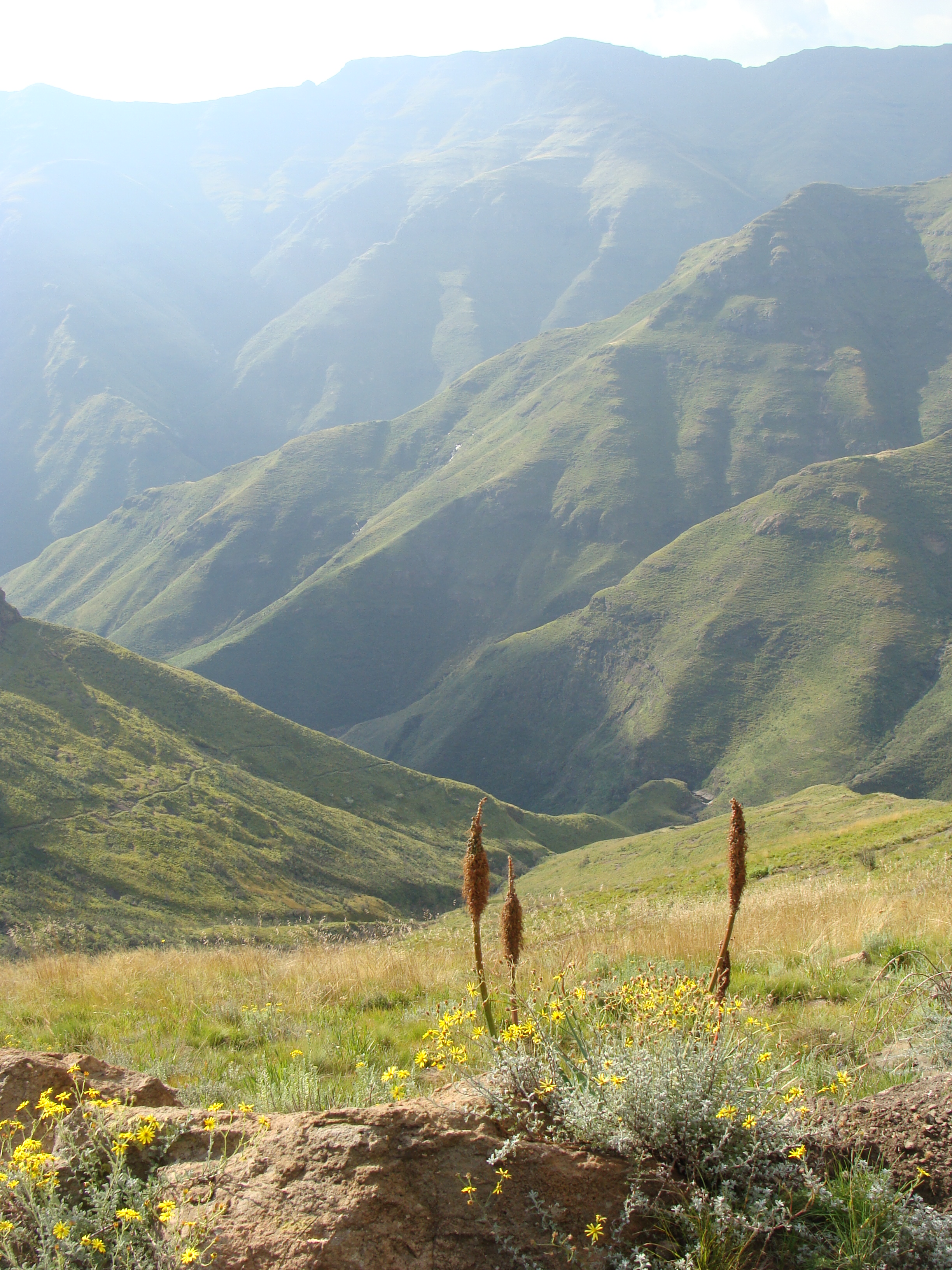
At altitudes ranging from 1,940 to 2,600 meters, Ts'ehlanyane protects one of the few patches of indigenous forest in a country that is overwhelmingly grassland. The canopy belongs to the ouhout tree - Leucosidea sericea - a species so hospitable that a single entomological study in a similar forest at Golden Gate found 117 species of beetles living on it. Beneath the ouhout, ferns carpet the forest floor: Polystichum and Cheilanthes species thrive in the dappled shade, while resurrection ferns on the exposed rocky slopes survive desiccation by curling inward and springing back to life with the next rain. The diversity of habitat types is exceptional, driven by the enormous altitudinal range. Sub-alpine grassland gives way to scrub forest, which gives way to fynbos-like heathland found nowhere else on Earth.
The Butterfly and the Bamboo
Among the more than 220 flowering plant species recorded in the park, the berg bamboo holds a distinction beyond its cultural significance to the Basotho people. It is the sole host plant of the bamboo sylph, Metisella syrinx, an endangered butterfly whose survival is tied entirely to the fate of this one grass species. Where the bamboo goes, the butterfly goes. Where the bamboo vanishes, so does the sylph. This relationship - one species utterly dependent on another - makes Ts'ehlanyane's conservation role acute. The park also shelters rare mountain fynbos that occurs nowhere else in the world, and Lesotho's national plant, the spiral aloe, spirals its way across rocky slopes in formations that look more like mathematical models than living things. Over 180 flowering species bloom across the park's alpine meadows in summer.
Raptors and Rock Thrushes
The skies above Ts'ehlanyane belong to some of southern Africa's most impressive birds. Bearded vultures - the lammergeier - soar along the cliff faces, carrying bones to great heights and dropping them onto rocks to crack them open for marrow, a feeding technique unique among raptors. Jackal buzzards patrol the thermals alongside lanner falcons, while the orange-breasted rockjumper, a Drakensberg endemic, bounces between boulders on the high slopes. Lower down, malachite sunbirds flash iridescent green as they probe the tubular flowers of Erica and Phygelius along the stream banks. Cape buntings and rock buntings forage among the stones, and the ground woodpecker - one of the few woodpecker species that has abandoned trees entirely - hammers at the earth itself for ant larvae.
Water, Tunnels, and the Road In
The Lesotho Highlands Water Project, one of the largest infrastructure undertakings in African history, inadvertently created Ts'ehlanyane. The Mamohale tunnel - a 22-kilometer conduit carrying water from Katse Dam to the As River outfall near Clarens in South Africa's Free State province - required an access road driven deep into the Maloti Mountains. That road, completed in 1991, opened a valley so pristine that it demanded protection. Today, a 32-kilometer tarred road leaves the main A1 highway eight kilometers south of Butha-Buthe, passes through the village of Khabo, and follows the Hlotse River along the Holomo valley to the park gate. From the South African border post at Caledonspoort, the drive takes 45 minutes. The popular Free State town of Clarens is just 15 minutes beyond the border.
Trails Through the Kingdom
A spectacular 39-kilometer hiking trail links Ts'ehlanyane with the Bokong Nature Reserve, traversing some of the most dramatic mountain scenery in southern Africa. Shorter trails thread through the ouhout forest to the Matsa-Mararo waterfall, passing stands of night-flowering Zaluzianskya and the honey-scented blooms of Selago along the way. Basuto pony rides offer a traditional way to explore the terrain from a higher vantage point - the Basuto pony, bred for mountain work over centuries, handles the steep slopes and river crossings with nonchalance that would terrify a flatland horse. Swimming holes in the pristine mountain streams offer relief after a long hike, and at Maliba Lodge, the park's only accommodation within its boundaries, a viewing deck overlooks the forest canopy. The mountains do not hurry here. Neither should you.
From the Air
Located at 28.92S, 28.46E in the Maloti Mountains of northern Lesotho, near the Leribe District. The park sits at altitudes of 1,940-2,600 meters in deeply incised mountain valleys. Nearest international airport: O. R. Tambo International Airport (FAOR) in Johannesburg, approximately 4 hours by road. Nearest regional access: Moshoeshoe I International Airport (FXMM) in Maseru, Lesotho. The South African border post at Caledonspoort provides road access from the Free State. Look for the Holomo valley cutting northward into the Maloti range, with the Katse Dam visible to the south. Terrain is rugged sub-alpine with deep valleys and steep ridgelines. Expect turbulence near mountain ridges. Weather can change rapidly at altitude; cloud cover and mist are common. Recommended viewing altitude: 8,000-10,000 ft MSL for mountain ridge perspective.