Tsimanampetsotsa National Park
Somewhere in the limestone cliffs of southwest Madagascar, a fish navigates total darkness. Typhleotris madagascariensis has no eyes -- it has never needed them. Born in the subterranean pools of the Mahafaly Plateau, it hunts by sensing pressure waves in water that has filtered through rock for millennia. Above ground, the park named for the alkaline lake beside it is almost as improbable: a place where annual rainfall barely reaches 300 millimetres, where temperatures routinely exceed 40 degrees Celsius, and where the plants have responded by evolving into forms found absolutely nowhere else. Tsimanampetsotsa National Park, on Madagascar's arid southwest coast, protects one of the most biologically distinctive landscapes on the planet.
Where the Spiny Desert Begins
First protected in 1927 and designated a national park in 1966, Tsimanampetsotsa encompasses 432 square kilometres along the westernmost escarpment of the limestone Mahafaly Plateau. The vegetation here belongs to the Madagascar spiny forests ecoregion, listed among the 200 most important ecological regions in the world. The numbers are staggering: 48% of plant genera and 95% of species are endemic. Many belong to the Didiereoideae subfamily, thorny succulents found only in Madagascar's southwest, alongside xerophytic species from the spurge family. Walking through this landscape feels less like a forest and more like visiting another planet, where plants bristle with spines instead of leaves and trees store water in swollen trunks shaped like bottles.
Grandmother and the Polygamous Baobab
Along the trails that climb from the lake basin toward the plateau edge, two ancient baobabs have become landmarks. The first, called "Grandmother," is actually three trunks fused together over different centuries; the oldest section is an estimated 1,600 years old. The second, the "polygamous baobab," has six fused stems and is roughly a millennium old. These trees anchor a hike through the spiny forest where narrowly endemic species crowd the trail -- plants that exist in this corner of Madagascar and nowhere else. Nearby, the Mitoho Grotto holds a different kind of treasure. In the 1930s, the botanist Henri Perrier de la Bathie discovered subfossil remains of giant tortoises, crocodiles, eggshell fragments of elephant birds, and bones of the giant lemur Megaladapis edwardsi -- evidence of the spectacular megafauna that roamed Madagascar before human arrival.
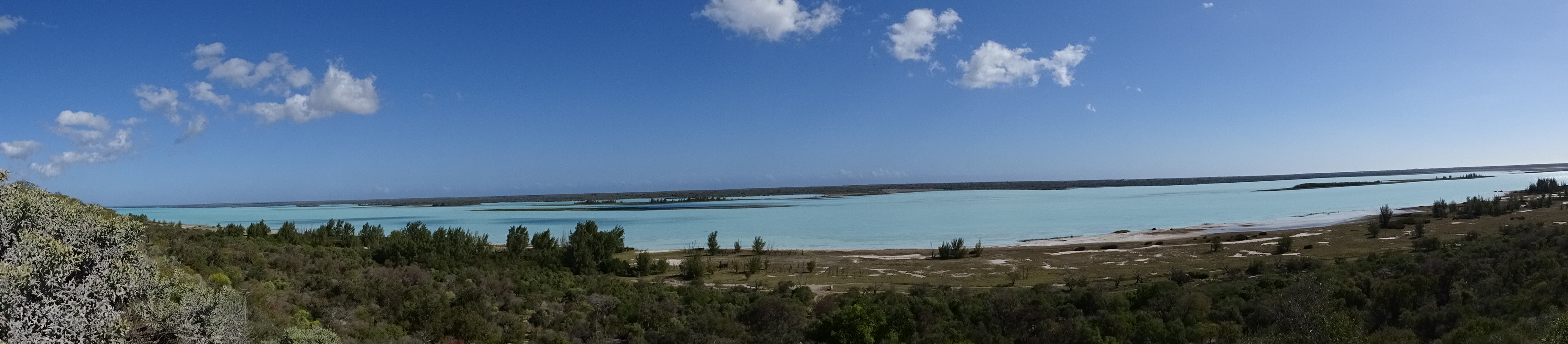
A Lake Without Fish
Lake Tsimanampetsotsa gives the park its name and much of its ecological identity. It is shallow, highly mineralized, and moderately alkaline, with salt concentrations approaching those of seawater. No fish survive in its waters. Instead, invertebrates from four taxonomic groups -- annelids, gastropods, crustaceans, and insects -- make up the aquatic community, their diversity limited by high phosphate concentrations from erosion. The lake was designated a Ramsar Wetland of International Importance in 1998. Along its shores, at least 112 bird species have been documented, 35 of them endemic to Madagascar. The endangered Madagascar grebe and the vulnerable Madagascan plover both depend on this inhospitable-looking body of water. In July 2018, the broader Tsimanampetsotse-Nosy Ve Androka region was established as Madagascar's fifth Biosphere Reserve.
The Sinkhole and Its Guardians
Past the baobabs, a trail leads to one of the park's most dramatic features: the Banyan Tree Sinkhole. About 25 metres in circumference, this vertical collapse in the limestone drops 10 to 12 metres to a pool. A large banyan fig grows at the edge, its roots reaching down the rock face into the water below. Fossils of extinct fauna have been found here too, a cross-section of the vanished world. Six lemur species inhabit the park, representing four of the five primate families endemic to Madagascar. By day, ring-tailed lemurs and Verreaux's sifakas move through the dry forest canopy. After dark, reddish-gray mouse lemurs, fat-tailed dwarf lemurs, and white-footed sportive lemurs emerge. Grandidier's mongoose, described as new to science only in 1986, hunts among the limestone cliffs -- one of the rarest carnivores on Earth, restricted to this narrow strip of coast.
From the Air
Located at 24.11S, 43.84E on Madagascar's southwest coast, 90 km south of Toliara. From altitude, the park presents as a pale limestone escarpment dropping to a distinctive alkaline lake visible as a white-rimmed basin against the brown-green spiny forest. Nearest airport is Toliara (FMST). The Mozambique Channel lies to the west. Route Nationale 10 runs along the park boundary. The arid landscape is visually distinct from the lusher eastern side of Madagascar.