Tucson, Arizona
The name repeats itself for emphasis. Tucson derives from the O'odham word Cuk Son, where cuk means black and son describes the base of something. The Tohono O'odham were referring to the dark volcanic rock at the foot of Sentinel Peak, the mountain that now bears a giant whitewashed 'A' for the University of Arizona. That act of naming, rooted in specific observation of specific geology, captures something essential about this place: people have been looking carefully at this landscape for at least 4,000 years, farming its floodplains, navigating its canyons, and building their lives around the rhythms of the Sonoran Desert. The Spanish founded Presidio San Agustin del Tucson here in 1775. Today, with 542,630 residents, Tucson remains Arizona's second-largest city -- and arguably its most distinctive.
Five Flags Over a River Valley
Recent archaeological excavations near the Santa Cruz River uncovered a village site dating to 2100 BC. The floodplain supported intensive farming during the Early Agricultural Period, with irrigation canals channeling water to crops of corn and beans. When Italian Jesuit missionary Eusebio Francisco Kino arrived in 1692, he encountered a sophisticated agricultural society. He founded Mission San Xavier del Bac in 1700, still an active parish and architectural treasure south of the modern city. The Spanish presidio followed in 1775. Mexico gained independence in 1821, making Tucson part of Sonora. The Gadsden Purchase of 1854 transferred the region to the United States. During the Civil War, Confederate forces briefly held the city before Union troops entered on May 20, 1862. Tucson was incorporated in 1877, making it the oldest incorporated city in Arizona. Five flags have flown here: Spanish, Mexican, Confederate, United States, and Arizona.
The Earp Vendetta Begins
On the night of March 20, 1882, Wyatt Earp and several trusted associates accompanied his brother Virgil and Virgil's wife Allie to the Tucson train station. Virgil, who had survived an assassination attempt in Tombstone three months earlier, was heading to California to recuperate. At the station, the group discovered Frank Stilwell, a suspected participant in the earlier ambush, apparently lying in wait among the rail cars. What happened next entered Western legend: Earp and his men killed Stilwell on the tracks. The killing launched the famous Vendetta Ride, with Wyatt and his posse hunting down men they believed responsible for attacks on his brothers. Tucson's role in this drama was brief but pivotal -- the moment when frontier justice shifted from courtroom to open range.
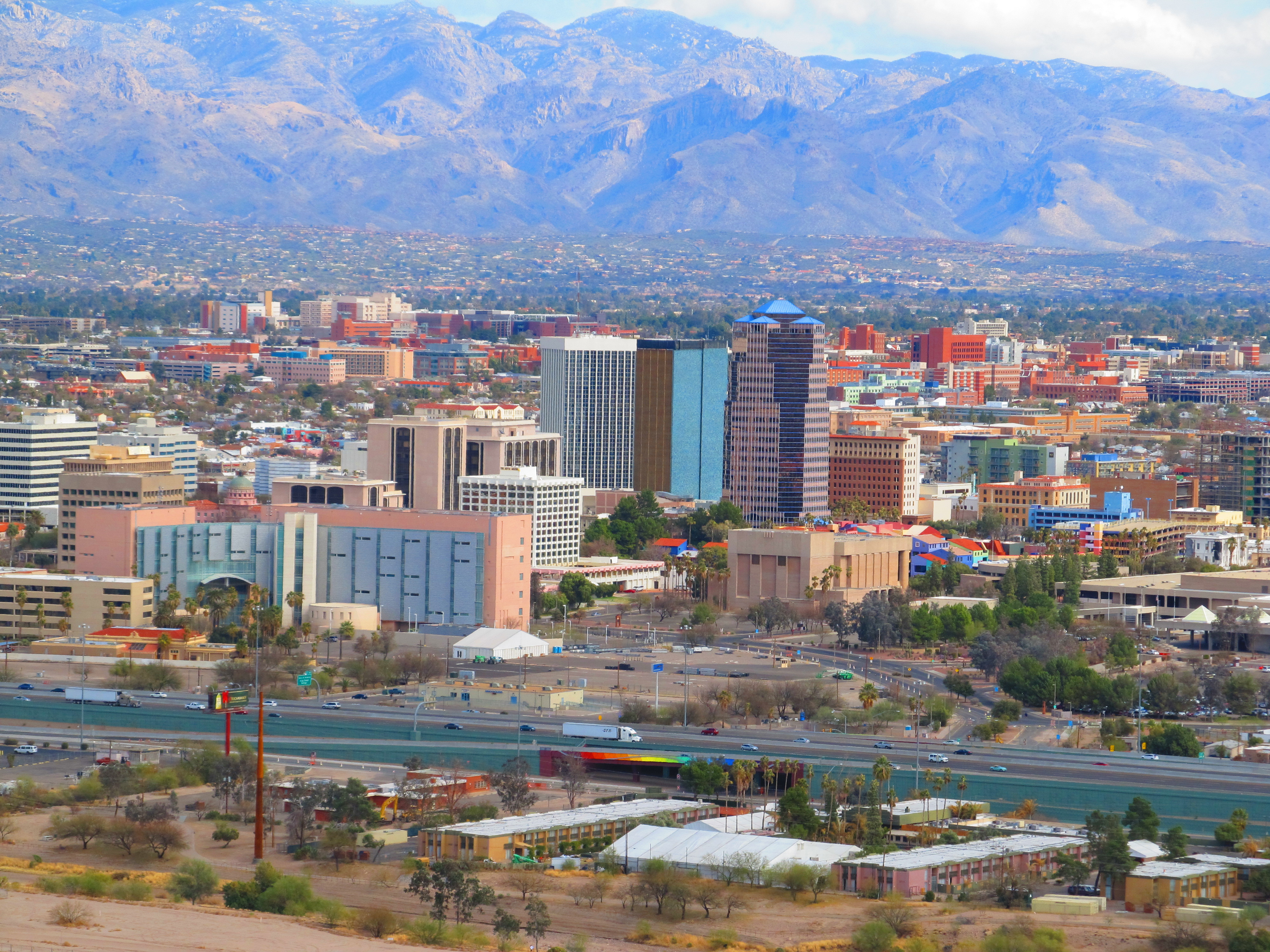
A Mountain Called A
Sentinel Peak rises just west of downtown, its distinctive profile visible from almost anywhere in the city. Starting around 1915, University of Arizona freshmen whitewashed a giant letter A on its slope, a tradition that has continued with various modifications ever since. After September 11, 2001, the A was painted red, white, and blue. When the Iraq War began in 2003, antiwar activists painted it black, triggering a back-and-forth that eventually required city council intervention. Today the A remains a visible symbol of the university's presence, which has shaped Tucson since the territorial legislature founded the land-grant institution in 1885 on what was then overgrazed ranchland between downtown and Fort Lowell. The university is now Tucson's largest employer, with research programs in optics and space sciences that have earned the city the nickname 'Optics Valley.'
Desert Cuisine, Global Recognition
In 2015, UNESCO designated Tucson a City of Gastronomy under its Creative Cities Network program -- the first American city to receive the honor. The recognition acknowledged what locals had known for generations: the desert surrounding Tucson is not empty space but a larder, with food traditions stretching back millennia. Mission Garden, a living agricultural museum at the base of Sentinel Peak, grows heritage crops and heirloom trees representing peoples who have cultivated this valley for over 4,000 years. The Sonoran hot dog -- bacon-wrapped, grilled, served on a bolillo bun with pinto beans, onions, tomatoes, and jalapeño salsa -- has achieved regional fame. Tucson also claims a contested birthright as the origin of the chimichanga. Chinese chorizo, a Sino-Mexican fusion dish born in local Chinese grocery stores between the 1880s and 1970s, now has its own annual festival.
The Mountains and the Monsoon
Five mountain ranges ring the valley: the Santa Catalinas and Tortolitas to the north, the Santa Ritas to the south, the Rincons to the east, and the Tucson Mountains to the west. Mount Wrightson in the Santa Ritas tops out at 9,453 feet. This geography shapes everything, from the city's characteristic red-rock aesthetics to its weather patterns. The North American Monsoon typically arrives in early July, transforming dry desert into a landscape of sudden storms, flash floods, and spectacular lightning displays. Arizona's 'Stupid Motorist Law,' enacted in 1995, allows the state to charge up to $2,000 to rescue drivers who ignore barricades at flooded roadways. The storms pass, the washes drain, and the saguaros and ocotillos resume their patient occupation of slopes they have held since long before any human arrived to give them names.
From the Air
Located at 32.2217°N, 110.9265°W at approximately 2,389 feet MSL in the Sonoran Desert. Tucson is ringed by five mountain ranges: Santa Catalinas (north, to 9,157 ft), Rincons (east, to 8,664 ft), Santa Ritas (south, to 9,453 ft), Tucson Mountains (west, to 4,687 ft), and Tortolitas (northwest). Tucson International Airport (KTUS) lies on the city's south side; Davis-Monthan AFB (KDMA) is southeast with extensive restricted airspace. Ryan Field (KRYN) serves general aviation to the southwest. The distinctive 'A' on Sentinel Peak is visible on approach from the northwest. The Santa Cruz River, typically dry except during monsoon season, traces through the western portion of the urban area. Best aerial views of the valley and surrounding ranges come from approaches between 8,000-12,000 feet.