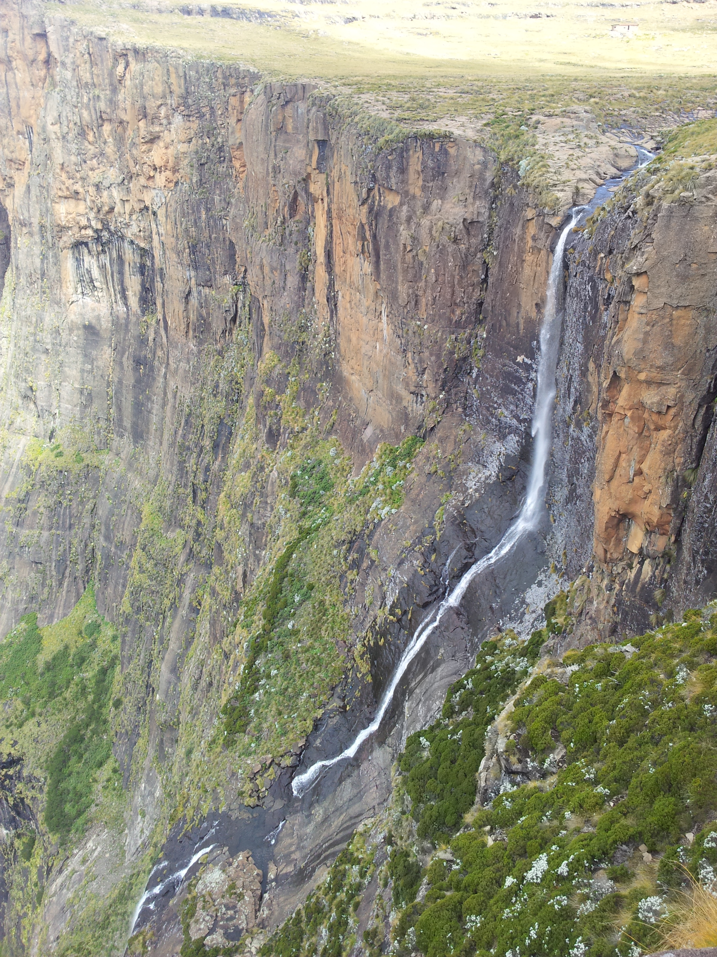
Tugela Falls
The argument has never been settled, and that is part of the appeal. Tugela Falls drops 948 meters in five distinct leaps off the Amphitheatre escarpment in KwaZulu-Natal -- or 983 meters, if you believe the Czech surveyors who re-measured it in 2016. Either figure puts it in direct competition with Venezuela's Angel Falls for the title of world's tallest waterfall, a contest complicated by the fact that both measurements were taken from considerable distance and neither has been independently verified to everyone's satisfaction. What is not in dispute is the spectacle: water plunging nearly a kilometer down a basalt cliff face, fed by the Mont-Aux-Sources plateau above, visible from the main road into Royal Natal National Park after a good rain.
The Measurement Wars
The official height of 948 meters has stood for decades, but it has never gone unchallenged. Angel Falls claims 979 meters -- a figure derived from American journalist Ruth Robertson's 1949 survey, though critics note that her measurement included not just the free-falling water but the entire altitude difference between the falls' crest and a river confluence nearly two kilometers downstream. In 2016, Czech scientists brought modern instruments to the Drakensberg and calculated Tugela at 983 meters, data they submitted to the World Waterfall Database. The database has yet to render a final verdict. What complicates the comparison is that Tugela's total height is split across five tiers, with the tallest single drop measuring 411 meters. Angel Falls boasts the world's longest uninterrupted free fall. So both waterfalls can claim superlatives -- just different ones.
Where the Water Begins
The Tugela River -- whose Zulu name, uThukela, means "sudden" -- rises on the Mont-Aux-Sources plateau, a high tableland that extends several kilometers behind the Amphitheatre's cliff edge. The plateau collects rain and snowmelt, channeling it toward the escarpment where the river makes its abrupt departure. Tugela Falls is seasonal. In the dry winter months, the cascades thin to ribbons or vanish entirely. After summer storms, the falls roar to life, sending plumes of mist billowing up the cliff face as the water hammers into each successive ledge. The surrounding landscape is alpine grassland at over 3,000 meters -- treeless, wind-scored, and dotted with lichen-covered boulders that have been sitting in place since the last ice age.
Two Paths to the Edge
Reaching Tugela Falls means choosing between two very different hikes. The top route begins at the Sentinel car park and climbs through a series of punishing zigzags to a chain ladder -- two sections, about 50 rungs each -- bolted to the cliff face. From the top of the ladder, a well-marked trail leads across the plateau to the falls' brink, where you can peer over the edge at nearly a kilometer of empty air. Those unnerved by the ladder can take the Gully, an alternative scramble that avoids the chains but demands confident footwork. The bottom route starts inside Royal Natal National Park and follows the Tugela Gorge for seven kilometers through indigenous forest. The trail ends in a boulder field where a small chain ladder leads to a viewpoint at the falls' base, water crashing down the Amphitheatre in five distinct cascades above you.
Dragon Mountains
The Drakensberg -- "Dragon's Mountains" in Afrikaans, uKhahlamba ("barrier of spears") in Zulu -- forms the eastern escarpment of southern Africa's high plateau. The Amphitheatre, the cliff wall from which Tugela Falls drops, is the most dramatic section: more than five kilometers of continuous cliff rising 1,220 meters from the valley floor. Royal Natal National Park protects this landscape, but the mountains have been a human landmark for far longer than the park has existed. San rock art in the surrounding caves dates back thousands of years, recording a people who knew these peaks and waterfalls intimately. Today the park draws hikers, climbers, and fly-fishers, but the falls remain the centerpiece -- a vertical river, seasonal and temperamental, that rewards those who arrive after the rains.
From the Air
Located at 28.75S, 28.89E in the northern Drakensberg, KwaZulu-Natal, South Africa. The falls are visible as a white streak on the Amphitheatre escarpment, best seen after rainfall. The Amphitheatre wall itself is unmistakable from the air -- a continuous 5 km cliff face rising to over 3,050 m ASL, with Mont-Aux-Sources (3,254 m) at its western end. Best viewed at 8,000-12,000 feet AGL approaching from the east or northeast. Nearest airports: Harrismith (no ICAO), or Pietermaritzburg (FAPM) approximately 200 km to the southeast. Terrain is mountainous with rapidly rising ground; maintain safe altitude. Weather can deteriorate quickly with orographic cloud formation along the escarpment.