Tulbagh
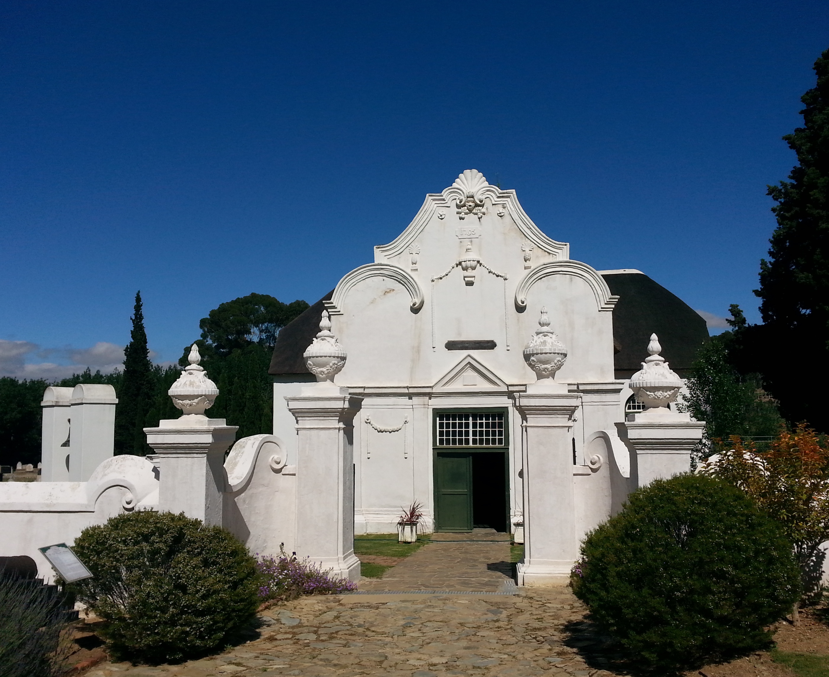
Thirty-two buildings stand on Church Street in Tulbagh, and every one of them is a National Monument. That is the largest concentration of declared monuments on a single street anywhere in South Africa, and the reason they exist in their current form is catastrophe. On September 29, 1969, a magnitude 6.3 earthquake shook the valley so violently that it damaged or destroyed every structure on the street. What stands today is a meticulous reconstruction -- Cape Dutch gables and Victorian facades rebuilt stone by stone, a town that chose to restore its past rather than replace it.
The Valley at the End of the Road
Tulbagh sits at the northern end of a valley almost completely enclosed by mountains. The Obiqua range rises to the west, the Witzenberg to the east, and the towering Great Winterhoek -- reaching 2,077 meters above sea level and snowcapped in winter -- closes the valley to the north. Europeans first arrived in 1658, but settlement did not begin until 1700, when land grants were issued to fourteen farming families. The town itself took shape in 1743 with the construction of its church. Originally called Roodezand for the red-hued sand and rocks at the valley's northwestern end, the settlement was renamed Tulbagh in 1805. The valley's near-encirclement by mountains gave it a sheltered, fertile character that attracted agriculture from the start.
Seventy Percent of the Plums
The productive valley punches well above its weight. Tulbagh and its surroundings produce some of South Africa's best red and white wines, along with olive oil, peaches, grain, and pears. The valley's most remarkable statistic: it produces roughly 70 percent of the country's plums. Proteas grow wild on the mountain slopes, and buchu -- the aromatic herb long used by the Khoikhoi and now prized in the natural health industry -- flourishes throughout the area. In spring, wildflowers blanket the hillsides while fruit trees blossom in the orchards below, and the wine route that threads through the basin connects estates that have been producing wine on a commercial scale for generations.
After the Shaking Stopped
The 1969 earthquake devastated three towns in the valley -- Tulbagh, Ceres, and Wolseley -- killing twelve people and leaving Church Street in ruins. The response was extraordinary. Rather than demolish and modernize, the community formed the National Committee for the Restoration of Historic Buildings in Tulbagh and its Environment, later succeeded by the Tulbagh Valley Heritage Foundation. Every building on Church Street was restored to its historical appearance, preserving Cape Dutch, Victorian, and Edwardian architectural styles that spanned two centuries. The reconstruction turned a disaster into a heritage precinct that now draws visitors specifically to walk a single street where South Africa's colonial architectural history is compressed into a few hundred meters.
A Village Calendar
Tulbagh keeps its traditions close. In June, the village celebrates Christmas in Winter -- a festive season event timed to the Southern Hemisphere's actual cold months rather than the December summer. September brings the Tulbagh Spring Arts Festival, showcasing visual and performing arts, followed immediately by the annual Horse and Wildflower Show. Cape Town is 120 kilometers away, and neighboring towns like Wellington, Paarl, Franschhoek, Stellenbosch, and Worcester are all within a forty-five-minute drive. But Tulbagh's appeal is precisely that it does not feel connected to any of them. Enclosed by its mountains, anchored by its reconstructed street, the town exists in a pocket of the Western Cape that seems to run on its own clock.
From the Air
Tulbagh is located at 33.29S, 19.14E in an enclosed mountain valley at approximately 170m elevation. From the air, the town is identifiable at the northern end of a distinctive valley bounded by the Obiqua Mountains (west), Witzenberg range (east), and the snow-capped Great Winterhoek (north, 2,077m). Church Street, with its row of restored Cape Dutch buildings, is visible as a compact historic core. Nearest airports: Cape Town International (FACT, ~120km S). Look for the vineyards and orchards filling the valley floor, and the mountain passes threading through the surrounding ranges.