Tuolumne Grove
They were chasing a wounded deer when they found the trees. On May 10, 1858, Dr. J. L. Cogswell and eight companions from Garrote, California, were hunting near Crane Flat in the Sierra Nevada when the deer vanished into the forest and they stumbled into a cluster of giant sequoias. Cogswell named the largest hollow tree "King Solomon's Temple" and sent a report to the San Francisco Evening Bulletin. Almost overnight, Tuolumne Grove became a destination. The grove is modest by sequoia standards - about 25 mature trees spread across 20 acres - but its history is outsized. This is where the idea of driving through a living tree was born, where stagecoach tourists first gaped upward at trunks wider than their wagons, and where the complicated relationship between Americans and their oldest, largest organisms began to take its modern shape.
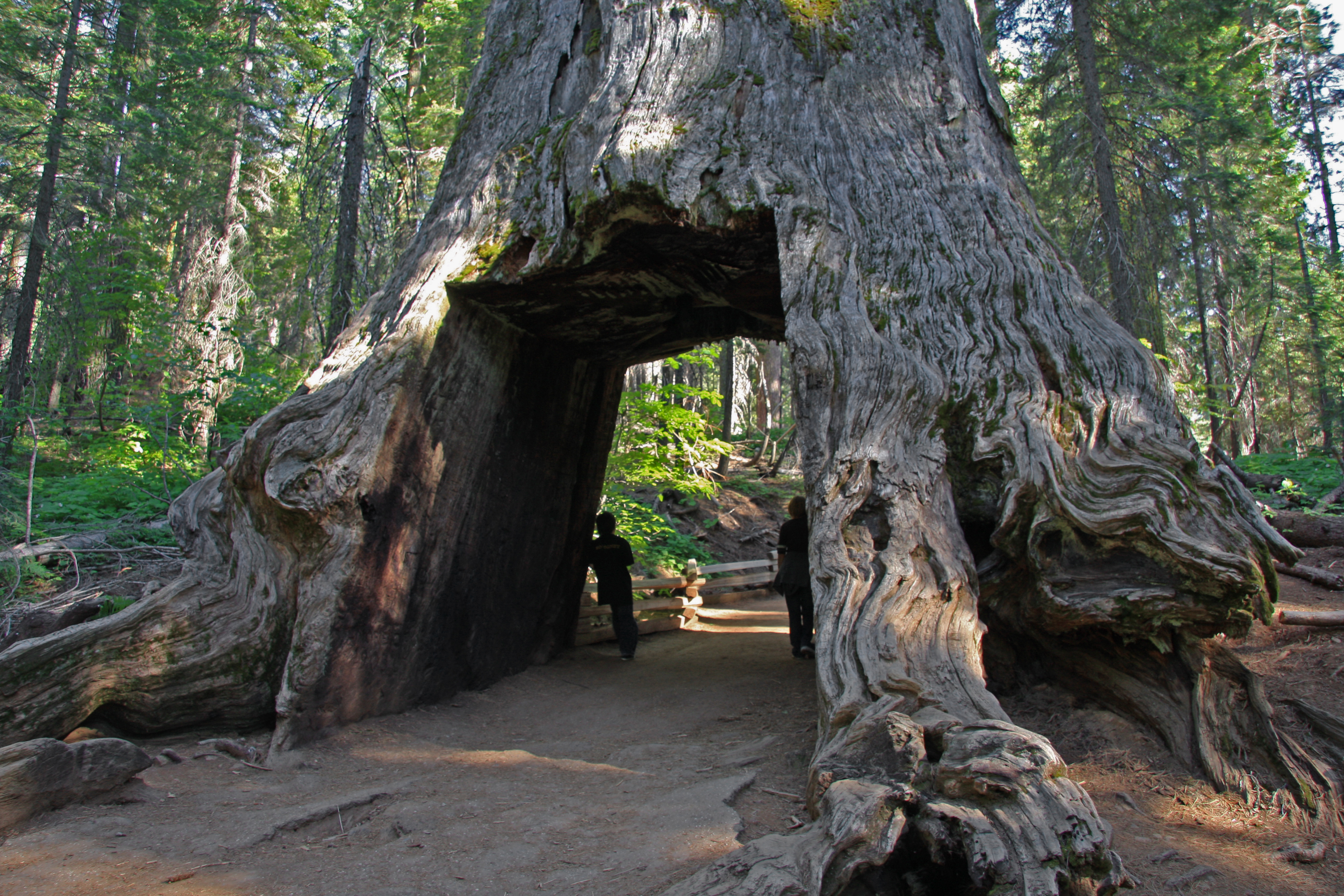
The First Tunnel Tree
In 1878, William McCarthy and brothers James J. and Dave Lumsden took axes and saws to the Dead Giant, a burned-out sequoia stump measuring 29 and a half feet in diameter at its base. They carved a 12-foot-high tunnel through the trunk so that stages and wagons on the road between Crane Flat and Yosemite Valley could pass directly through it. The Dead Giant became the first tunnel tree - a spectacle that would be replicated across the Sierra in the decades that followed. Stagecoaches regularly traversed the opening, and the image of a horse-drawn coach framed inside a living tree became one of the most recognizable symbols of California tourism. The practice seems strange now, an era's casual willingness to mutilate the thing it claimed to celebrate. But the tunnel trees served a purpose beyond novelty: they made the abstract scale of the sequoias visceral. You could read that a tree was 30 feet wide, or you could drive through one and understand it in your bones.
Gateway to the Valley
By the late nineteenth century, Tuolumne Grove was a deliberate stop on the overland route into Yosemite. Stage and wagon roads connected Big Oak Flat, near present-day Groveland, to Yosemite Valley via Crane Flat, and the route was designed to thread visitors through the grove of "mammoth trees" before they descended into the valley itself. Newspaper advertisements and travel guides from the 1860s through the 1880s promoted the ride "down the Tuolumne grove of big trees" as one of the journey's highlights. The trail through the grove was improved to a wagon road in 1882-1883, and by 1917 the historic Big Oak Flat Road had been realigned and paved for automobiles. An original segment of the old road, known as the Old Tioga Road, still leads hikers and snowshoers into the grove today - the same path that stagecoach passengers once traveled while craning their necks at trees that were already ancient when Rome was founded.
The Walker Expedition's Glimpse
Tuolumne Grove was officially "discovered" by Cogswell in 1858, but the trees were almost certainly seen 25 years earlier. In 1833, the Joseph Walker Expedition crossed the Sierra Nevada in a harrowing traverse that brought the party through the Yosemite high country. Expedition journals describe encountering enormous trees, and the route's trajectory passes near Crane Flat. If Walker's party did see the grove, they left no formal record - they were focused on survival, not botany, having nearly starved crossing the range. The sequoias would have been just another astonishing detail in a landscape full of them. It took another generation, and a lost deer, before anyone thought to write down what was growing here and tell the newspapers about it.
Protected Ground
Tuolumne Grove has been part of Yosemite's protected lands since the park's creation. In 1864, Congress granted Yosemite Valley and the Mariposa Grove to California for preservation - one of the first acts of landscape protection in American history. When Yosemite was established as a national park by federal law in 1890, the boundaries were dramatically expanded to include much of the upper Tuolumne River watershed, encompassing the grove. The U.S. Army managed the park in the early twentieth century, maintaining trails and removing fallen logs to reduce fire risk. Over time, fire suppression gave way to prescribed burning as ecologists recognized that sequoias depend on fire to clear competing vegetation and open their cones. The grove today is reached by a one-mile hike down the old road from a trailhead on Tioga Pass Road, about 16 miles west of Yosemite Village. It is quieter than the more famous Mariposa Grove to the south, and the smaller scale makes the trees feel less like monuments and more like neighbors - impossibly old neighbors whose roots were drinking Sierra snowmelt before the first Egyptian pyramid was laid.
From the Air
Located at 37.7692°N, 119.81°W near Crane Flat in the western portion of Yosemite National Park, along Tioga Pass Road (California State Route 120). The grove sits at approximately 5,700 feet elevation on a forested ridge. From the air, the sequoias are distinguishable by their reddish-brown bark and massive crowns among the surrounding white fir and sugar pine. Best viewed at 3,000-5,000 ft AGL. Nearest airports: Fresno Yosemite International (KFAT), 70 miles south; Columbia Airport (O22), approximately 35 miles west. The Crane Flat junction of SR-120 and the Big Oak Flat Road is a useful visual reference.