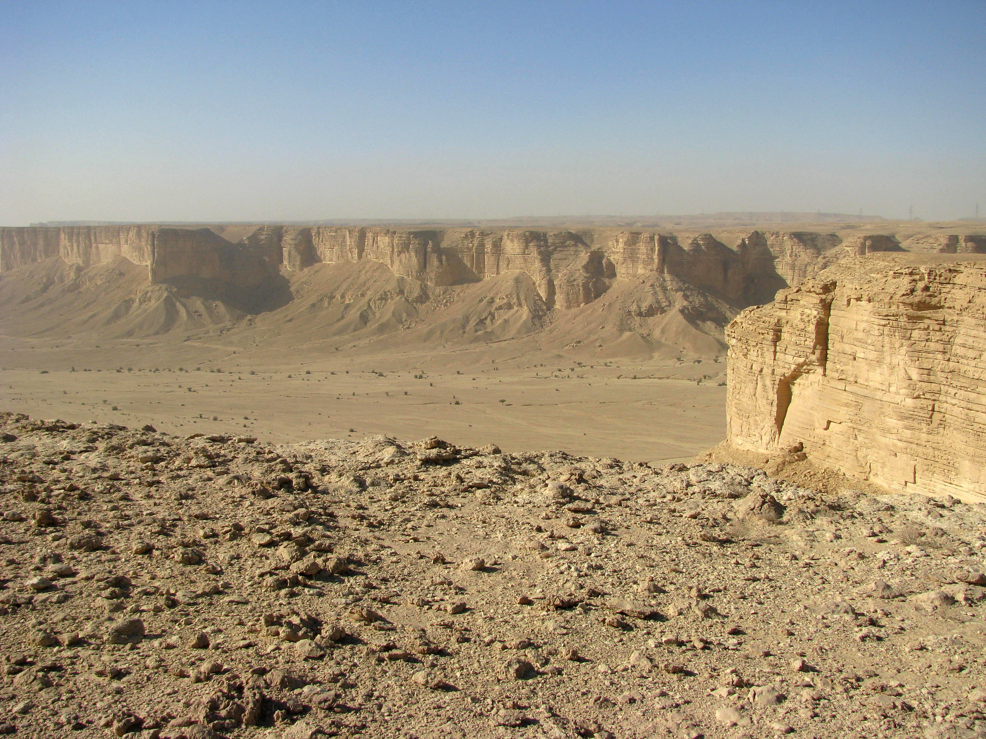
Tuwaiq Escarpment
From the air, it looks like a scar drawn with a ruler across the beige emptiness of central Arabia. The Tuwaiq Escarpment runs for 800 kilometers through the Najd plateau, a narrow wall of Jurassic limestone that rises 600 meters on its western face before tapering off gently to the east. The Saudi capital Riyadh sits along its central section, a city of millions tucked against a geological feature that predates human habitation by roughly 160 million years. The locals call it a jebel -- a mountain -- though it behaves more like an enormous cliff turned sideways, its abrupt western edge dropping into deep wadis while its eastern flank slopes away toward the sands of the Rub' al Khali.
A Wall Through Deep Time
The escarpment stretches from the southern border of Al-Qasim province in the north to the edge of the Empty Quarter near Wadi ad-Dawasir in the south. Its Middle Jurassic limestone tells a story older than the Arabian Peninsula's deserts: this rock formed on the floor of a shallow tropical sea, in an era when the landmass that would become Arabia was still attached to Africa. The Tuwaiq Mountain limestone, as geologists call the formation, contains some of the best-preserved Jurassic stratigraphic sections in the region. Narrow valleys -- wadis -- cut into both flanks. Wadi Hanifa, the most famous, runs past Riyadh and historically sustained the settlements that grew along the escarpment's central spine. Towns on both sides, including those of the Sudair and Al-Washm regions, owe their existence to the water these valleys channeled through otherwise punishing terrain.
The Name That Shifted
The 13th-century geographer Yaqut al-Hamawi recorded this escarpment in his encyclopedic Mu'jam al-Buldan under the name Al-'Aridh, a term that once described the entire formation. Over the centuries, that name narrowed. Today Al-'Aridh refers only to the central section around Riyadh, while the broader feature carries the name Tuwaiq -- sometimes written Tweig -- which the publisher Marshall Cavendish rendered as the "Tuwayr Mountains" when distinguishing them from the Shammar Mountains to the north, the Dhofar Mountains to the south, and the Hajar range to the east. These naming shifts track the political and cultural evolution of the peninsula itself: as Riyadh grew from a walled settlement into a national capital, its immediate geography absorbed the older regional name, and a newer one spread to cover the rest.
Oceans of Oil Beneath the Stone
Beneath the escarpment lies something far more valuable than limestone. The Arab-D reservoir, an Upper Jurassic formation within the Riyadh Group, constitutes one of the largest petroleum reservoirs on Earth. Saudi Aramco and partner researchers have used high-resolution LIDAR surveys of the Tuwaiq Mountain limestone outcrops to build three-dimensional geologic models, treating the exposed cliff faces as analogs for the reservoir rock buried thousands of meters below. The challenge is scale: seismic data can map reservoir structures larger than 30 meters, but the flow-unit properties that determine how oil actually moves through rock operate at scales of 1 to 30 meters -- far below what imaging can resolve. By scanning the exposed outcrops with laser precision, geologists can characterize the Jurassic bioherms that control subsurface flow, bridging the gap between what satellites see and what drilling encounters.
A Desert Playground
In February 2019, a group of 100 young hikers set out on the Tuwaiq Mountains Challenge, covering roughly 25 kilometers along the escarpment's ridgeline. The event was part of Saudi Arabia's broader push toward entertainment and tourism, a signal that a landscape long valued primarily for what lay beneath it was beginning to attract attention for what rose above. The views from the ridge justify the effort. To the west, the escarpment drops away sharply, revealing layered canyon walls and desert washes that glow amber in low-angle light. To the east, the land descends gradually toward the urban sprawl of Riyadh, the contrast between raw geology and modern city visible in a single sweeping glance. Highway 40, the main road from Riyadh to Makkah, threads through the escarpment's terrain, offering drivers a cross-section of the same rock that geologists study with laser scanners.
From the Air
The Tuwaiq Escarpment is centered near 19.91N, 45.25E, running roughly north-south for 800 km through central Saudi Arabia. Its western cliff face is the most dramatic visual feature, best seen at altitudes between 5,000 and 15,000 feet AGL. Riyadh (OERK) lies along the central section. Nearby airports include King Khalid International (OERK) and Prince Nayef bin Abdulaziz Airport at Al-Qasim (OEAO). Visibility is generally excellent in the dry interior, though sandstorms can reduce it dramatically. The escarpment is most visually striking in early morning and late afternoon light.