Urup
In the Ainu language, urup means sockeye salmon. The island that bears the name is the fourth largest in the Kuril chain, a 120-kilometer slab of volcanic rock running northwest to southeast through the Sea of Okhotsk. Nobody lives here permanently anymore. The Ainu are gone. The Japanese garrison surrendered in 1945. The Soviet border troops withdrew in 1991. What remains is four groups of volcanoes, colonies of seabirds, and a gold mine operated by temporary workers — the last human enterprise on an island that five nations have, at various points, tried to claim.
A Landscape of Extremes
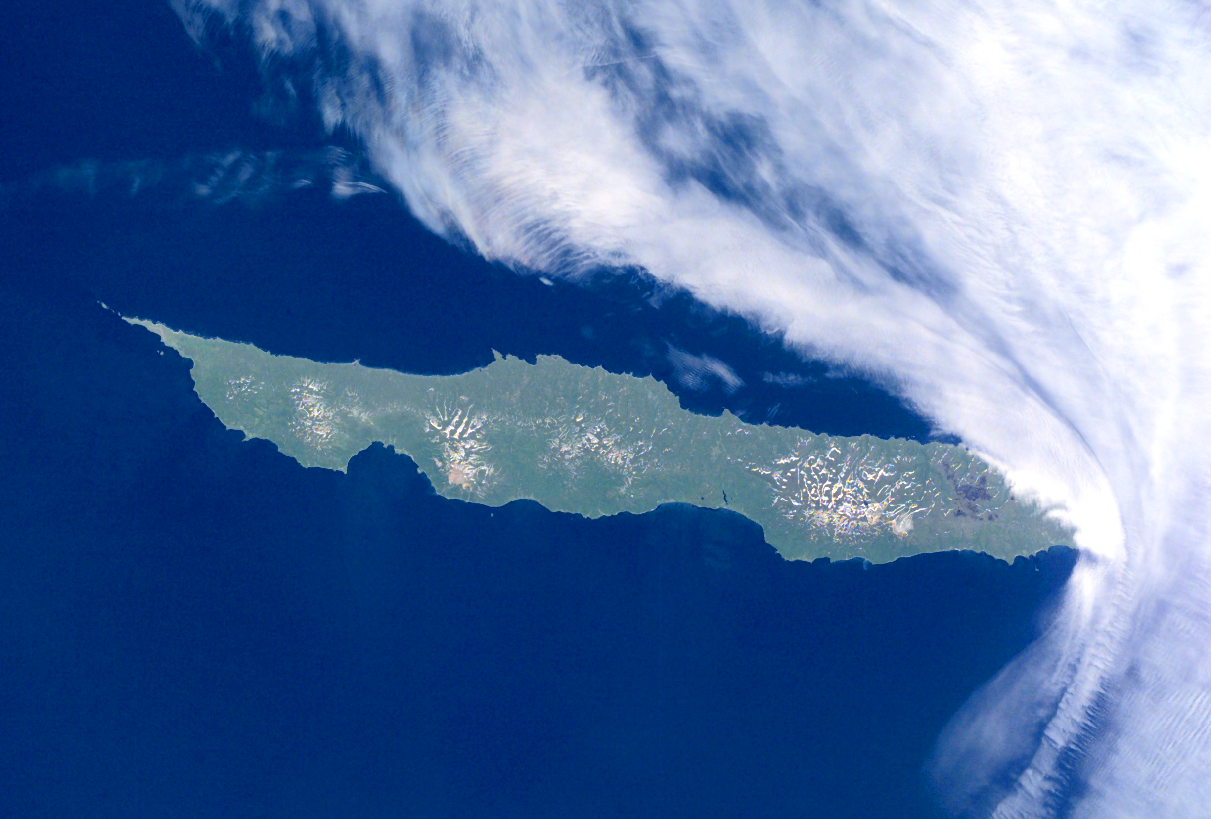
Urup is essentially rectangular, 120 kilometers long and 20 wide, with an area of 1,430 square kilometers. Four volcanic groups define the terrain. The Kolokol Group, at 1,328 meters, erupted as recently as 1973. Rudakov, a 524-meter cone, holds a funnel-shaped crater with a lake 300 meters across. Tri Sestry — Three Sisters — rises to 998 meters, its flanks carved by deep ravines and dotted with hot springs. The Ivao Group reaches 1,426 meters, the island's highest point, where a volcanic cone bisects a glacial valley to form yet another lake. Despite sitting at a temperate latitude, the cold Oyashio Current and the Aleutian Low give Urup a subarctic climate: foggy summers, brutal winters, and a seasonal lag so extreme that temperatures at the autumn equinox are typically warmer than at the summer solstice.
Phantom Islands and Real Ambitions
In 1643, the Dutch ship Castricum under Maarten Gerritsz Vries became the first recorded European vessel to reach this part of the Kurils. Vries's confused account — longitude was nearly impossible to calculate accurately — spawned the phantom island Company Land, a nonexistent continent that haunted European maps for over a century. A Japanese map from 1644 already showed Urup as Matsumae clan territory. Russian fur traders arrived in the late 18th century, hunting sea otter and clashing with the Ainu in 1772. The fur trader Ivan Chernyi established a small Russian outpost in 1768, which became a base for trade attempts with Japan until a tsunami destroyed it in June 1780. A decade later, forty Russian colonists under Zvezdochetov founded a settlement they named Slavorossiia.
The Crimean War Reaches the Pacific
In 1855, as Russia and Japan divided the Kurils through the Treaty of Shimoda, the Crimean War brought yet another set of claimants. A Franco-British naval force, led by HMS Pique and the French frigate Sybille, arrived at the Russian settlement of Tavano in late August. Captain Nicolson found wooden houses, storehouses, and Ainu huts — but no Russian garrison. The residents had left before the warships arrived. On September 2, the allies raised the Union Jack and the French tricolor, renamed Urup 'l'Isle de l'Alliance,' and appointed a local Aleut inhabitant as provisional governor. They sailed away the next day. The Treaty of Paris returned the island to Russian control. That same year, two American whaleships — the King Fisher and the Enterprise, both out of New Bedford — wrecked on a reef at Urup's northeast end while trying to pass through Bussol Strait into the Sea of Okhotsk. All hands survived.
Garrison Island
Under the 1875 Treaty of Saint Petersburg, the entire Kuril chain passed to Japan. The remaining Aleut inhabitants were transferred to Kamchatka and replaced by Japanese colonists. During World War II, all civilians were relocated to the home islands, and the Imperial Japanese Army stationed approximately 6,000 troops on Urup, including the 129th Independent Mixed Brigade and a tank company. When Soviet forces invaded the Kurils in August 1945, the Japanese garrison on Urup surrendered without resistance. Soviet border troops moved in, erecting a P-14 "Tall King" air defense radar on the northeastern tip. They built lighthouses on the easternmost and westernmost capes. In 1952, Japan formally renounced its claim through the Treaty of San Francisco.
Empty but Not Forgotten
The Soviet troops withdrew when the USSR dissolved in 1991. Their airfield was converted to a bombing range. Today the island's only economic activity is a gold and silver mine called KurilGeo, formerly owned by the Solway Group and reportedly sold to an Armenian company in 2022. Crested auklets, tufted puffins, pigeon guillemots, and black-legged kittiwakes nest along the shores in spring and summer — the island belongs more to seabirds now than to any nation. Urup is administered as part of Sakhalin Oblast, but its real character is solitude. The volcanoes steam. The fog rolls in. The sockeye salmon, for which the Ainu named this place, still run through the surrounding waters.
From the Air
Located at 45.90°N, 149.98°E in the central Kuril Islands. Urup is 120 km long and oriented NW-SE, easily identifiable by its rectangular shape and four volcanic groups, the tallest peak being Gora Ivao at 1,426 m. No active airfield exists on the island — the former military strip is now a bombing range. Nearest airports are on Iturup (UHSI, approximately 37 km to the southwest) and Sakhalin Island (UHSS, Yuzhno-Sakhalinsk). Bussol Strait separates Urup from Simushir to the northeast; the Vries Strait separates it from Iturup to the southwest. Persistent fog is common, especially in summer. Subarctic conditions year-round.