Valle Nuevo National Park
Frost in the Caribbean sounds like a contradiction. Yet on winter mornings in Valle Nuevo, ice crystals coat the grasses of a highland plateau that sits above 2,200 meters, where temperatures drop to minus seven degrees Celsius and the air feels nothing like the tropical coast two hours below. This is the Dominican Republic's improbable alpine world, a remnant of the last ice age perched atop the Cordillera Central, where Nearctic vegetation grows on a Caribbean island and cloud forests drip with moisture that feeds rivers supplying half the country. Formally known as Juan Bautista Perez Rancier National Park, Valle Nuevo was established in 1996 to protect 910 square kilometers of this ecological anomaly. Its highest point, the extinct volcano Loma Alto de la Bandera, reaches 2,842 meters, making it one of the tallest summits in the entire Caribbean. The name means "new valley," but what survives here is ancient.
Ice Age Remnant in the Tropics
Valle Nuevo exists because of glaciers. During the Last Glacial Maximum, ice covered the peaks of the Cordillera Central, and as it retreated, it left behind a high plateau with conditions found nowhere else in the Caribbean. The vegetation here belongs to the Nearctic ecozone, the same biological realm that governs the forests of North America. Pine species, cloud forest endemics, and alpine grasses grow in soils shaped by volcanic activity and glacial retreat. Walk the trails above 2,200 meters and the landscape shifts abruptly from the lush tropical montane forest below into something cooler, sparser, and stranger. The cloud forests of Mechecito and Pichon harbor species like palo de viento, ebony, and the enigmatic cara de hombre. It is a place that defies the postcard image of the Dominican Republic, trading white sand beaches for wind-battered ridgelines and fog-wrapped valleys.
Where a President Fell
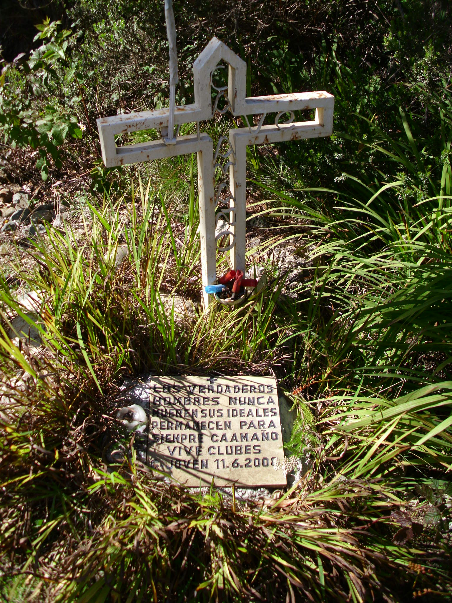
A small iron cross stands along the unpaved road that bisects the park, marking a site of political violence that few tourists notice. Francisco Caamano, who served as provisional president of the Dominican Republic during the 1965 civil war, returned from exile in 1973 to take up arms against the government of Joaquin Balaguer, which he considered illegitimate. His guerrilla campaign ended in these mountains. Captured and executed, Caamano became a martyr for Dominican progressives, and the cross in Valle Nuevo remains a pilgrimage site. The road itself, Route 41, also called Antonio Duverge, runs north to south through the park and passes through a section called La Nevera, "the icebox," named for the bone-deep cold that settles over the plateau. Near La Nevera sits a pyramid monument divided into four segments, once used to help distinguish the various peaks from one another. History and geography are tangled here, inseparable.
The Coldest Corner of the Caribbean
Valle Nuevo routinely records the lowest temperatures in the Dominican Republic. Frost and ice formations are common from November through February, with lows reaching minus seven degrees Celsius. In 2003, the National Meteorological Office installed an automatic weather station on the plateau, transmitting data on temperature, humidity, rainfall, barometric pressure, solar radiation, and wind speed. It operated until 2008, went silent, and was reactivated in 2010 to resume hourly updates. The data confirmed what locals already knew: this place behaves like no other in the Caribbean. The cold shapes everything, from the stunted vegetation to the daily rhythms of the park's wildlife. Hikers who arrive expecting tropical warmth find themselves shivering at altitude, watching their breath cloud in air that smells of pine and wet stone.
Scars and Renewal
In February 1983, a fire swept through Valle Nuevo and destroyed 32 square kilometers of forest. The blaze was devastating enough to prompt the government to declare the area a scientific reserve that same year, a designation that would eventually lead to full national park status in 1996. Fire remains a persistent threat on the plateau, where dry seasons can turn the alpine grasses into tinder. But the park's ecological importance extends far beyond its own boundaries. The rivers that originate in Valle Nuevo's cloud forests supply water to towns and agricultural communities across the central Dominican Republic, making the park a critical watershed. Controversies over illegal farming within the park's borders have periodically erupted, with the government setting deadlines for removing agricultural operations from protected land. The tension between conservation and the economic needs of surrounding communities remains unresolved, a struggle as old as the park itself.
A Living Laboratory
Valle Nuevo draws birdwatchers, hikers, campers, and researchers who come to study an ecosystem that exists in Caribbean isolation. The park's ecotourism potential is immense, though infrastructure remains limited. Unpaved roads challenge even experienced drivers, and facilities are sparse. What the park lacks in polish, it compensates for with strangeness. Nowhere else in the Caribbean can you stand on a glacially carved plateau, surrounded by Nearctic vegetation, watching endemic bird species flit through cloud forest while frost melts on the ground beneath your boots. Significant peaks beyond Loma Alto de la Bandera include Loma del Macho, Tetero de Mejia, and Loma Cabeza del Rio, each offering different perspectives on a landscape that feels transplanted from another continent. For those willing to endure the cold and the rough roads, Valle Nuevo rewards with the kind of silence and solitude that the busier coasts cannot offer.
From the Air
Located at 18.71N, 70.60W in the Cordillera Central of the Dominican Republic. The plateau sits above 2,200 meters (7,218 feet) with the peak of Loma Alto de la Bandera at 2,842 meters (9,324 feet). Approach from the north near Constanza, approximately 15 km from the park boundary. The nearest major airport is Cibao International Airport (MDST) near Santiago, roughly 100 km north. La Isabela International Airport (MDJB) in Santo Domingo is approximately 150 km southeast. At altitude, the plateau is visible as a broad highland area within the Cordillera Central range, distinguishable by its sparse alpine vegetation contrasting with denser forests on surrounding slopes. Expect variable weather with frequent cloud cover and cold conditions at the plateau level. Route 41 is visible as an unpaved road crossing the park north to south.