Venezuelan Andes
The Andes begin at the southern tip of South America and run 7,000 kilometers north through seven countries before arriving in Venezuela, where the chain makes its last gesture. Here, the Cordillera Oriental of Colombia splits into two branches as it crosses the border: the Sierra de Perija, a smaller range running along the Colombian frontier with 7,500 square kilometers in Venezuelan territory, and the Cordillera de Merida, the main event, stretching 40,000 square kilometers across the states of Tachira, Merida, and Trujillo. Together, these two branches compose the Venezuelan Andes -- the northernmost extension of the longest continental mountain chain on Earth, covering 5.2 percent of Venezuela's national territory and containing the country's highest point.
Three Plates, One Mountain Range
The Venezuelan Andes exist because three tectonic plates refuse to get along. The Nazca Plate, the Caribbean Plate, and the South American Plate converge in northwestern South America, and their collision has been pushing rock skyward since the Eocene epoch, roughly 40 to 50 million years ago. But these are not the first mountains to occupy this ground. Between the Cambrian and Silurian periods, a set of primitive Andes rose from an earlier geological era, only to be ground nearly flat by erosion during the Triassic. The current range is a second act, built on the eroded foundations of the first. The compression between the plates runs roughly northwest to southwest, producing both vertical uplift and horizontal displacement along strike-slip faults -- fractures where blocks of earth slide past each other rather than riding over or under.
The Bocono Fault
The most significant of these strike-slip faults is the Bocono Fault Zone, which runs along the spine of the Cordillera de Merida like a seam in the Earth's crust. It has been active since the Early Holocene, and GPS measurements record it slipping at four to six millimeters per year -- a rate that sounds trivial until you multiply it by geological time. The fault has been associated with destructive earthquakes, including events in 1610 and 1894. Its surface expression is visible in the landscape as fault trenches, sag ponds, offset ridges, and displaced lateral moraines -- features that geologists read like a record of the Earth's restlessness. The Bocono Fault is a reminder that these mountains are not finished products. They are still being built, still being broken, still shifting under forces that human timescales struggle to register.
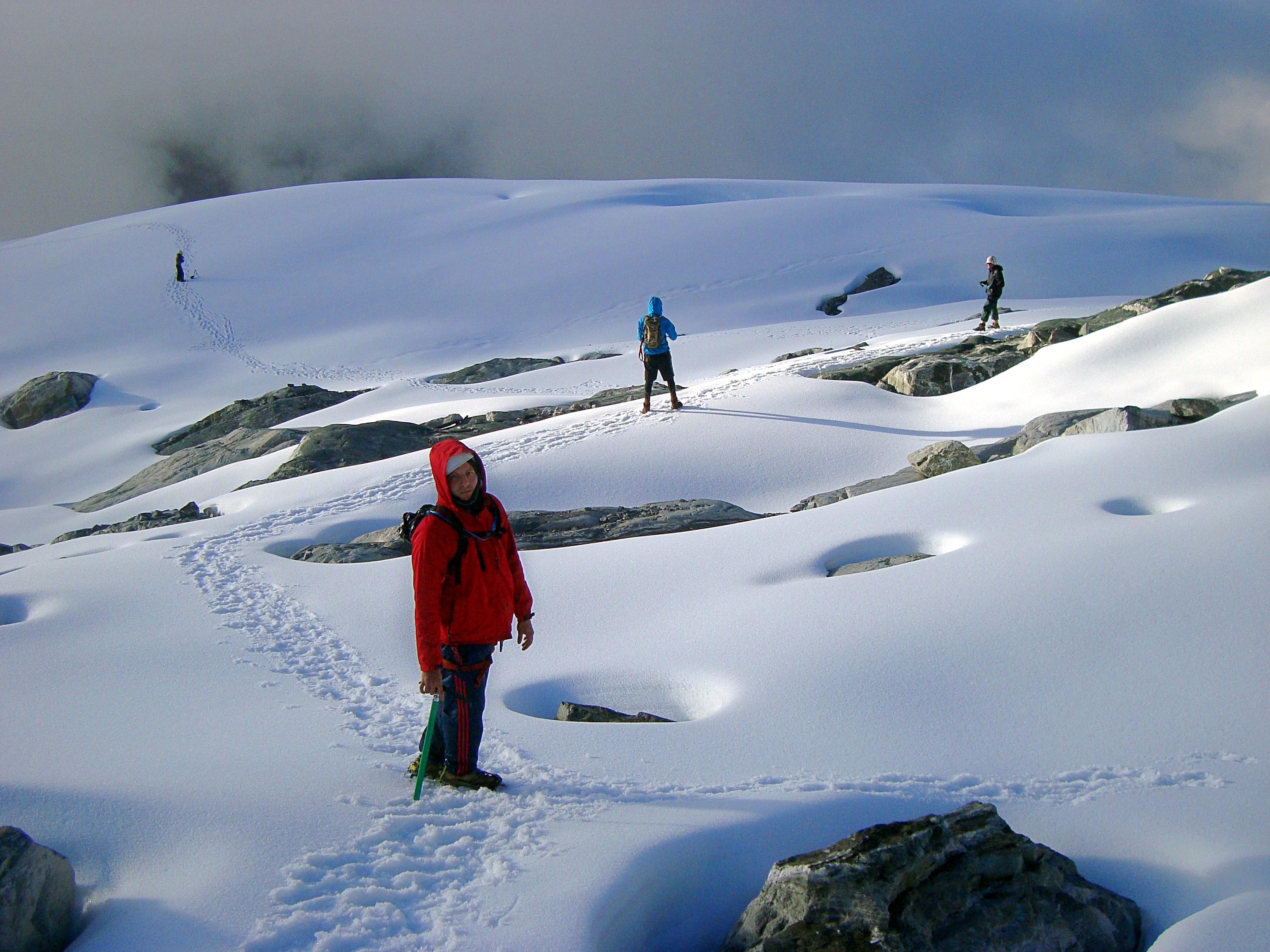
Ice Ages in the Tropics
It is easy to forget that tropical mountains had glaciers. The Venezuelan Andes, with peaks above 4,900 meters, were extensively glaciated during the Pleistocene. Two morainic complexes in the Cordillera de Merida record the advance and retreat of ice: one set of deposits between 2,600 and 2,800 meters altitude, and a higher set between 2,900 and 3,500 meters, representing the early and late stages of the Merida glaciation. During the Last Glacial Maximum, roughly 20,000 years ago, approximately 600 square kilometers of the Cordillera de Merida lay under ice. The Sierra de Perija also carries evidence of glaciation, with moraines found between 2,700 and 3,100 meters. Even the Little Ice Age, the cold period between the 15th and mid-19th centuries, left its mark -- moraines from that phase sit at about 4,700 meters, just 100 to 200 meters below where the last remnants of ice clung into the modern era.
Two Branches, Two Characters
The Cordillera de Merida and the Sierra de Perija may share a geological origin, but they have distinct personalities. The Cordillera de Merida is the dominant range -- higher, broader, more densely populated, and more ecologically varied. It can be subdivided into three regions: the western Andes around the Macizo del Tama, the central Andes containing the Sierra Nevada de Merida and Sierra de la Culata, and the northeastern Andes where the Sierra de Trujillo and Sierra de Portuguesa descend toward the lowlands. The Sierra de Perija, by contrast, is wilder and less accessible, running along the Zulia state border with Colombia through territory that has historically been difficult to reach. Both branches drain into vastly different river systems: the Cordillera de Merida feeds the Orinoco to the southeast and Lake Maracaibo to the northwest, while the Sierra de Perija's streams run primarily into the Maracaibo basin. Together, they frame the western end of Venezuela with a wall of rock, forest, and paramo that defines the country's geography and shapes its climate.
From the Air
The Venezuelan Andes extend from the Colombian border in the southwest to the coastal ranges in the northeast, centered approximately at 8.75N, 70.917W. The system includes two branches: the Cordillera de Merida (40,000 km2, peaks to 4,978 meters / FL163) and the Sierra de Perija (7,500 km2 in Venezuela) along the Colombian border. Pico Bolivar at 4,978 meters (16,332 feet) is the highest point. Nearest airports: Alberto Carnevalli Airport (SVMD/MRD) in Merida, Juan Pablo Perez Alfonso Airport (SVSA) in El Vigia, La Fria Airport (SVLF) in La Fria. Extreme caution required: extensive high terrain, the Bocono Fault zone runs along the main ridge, frequent mountain weather with orographic cloud formation and turbulence. Terrain rises abruptly from the Maracaibo lowlands on the northwest side.