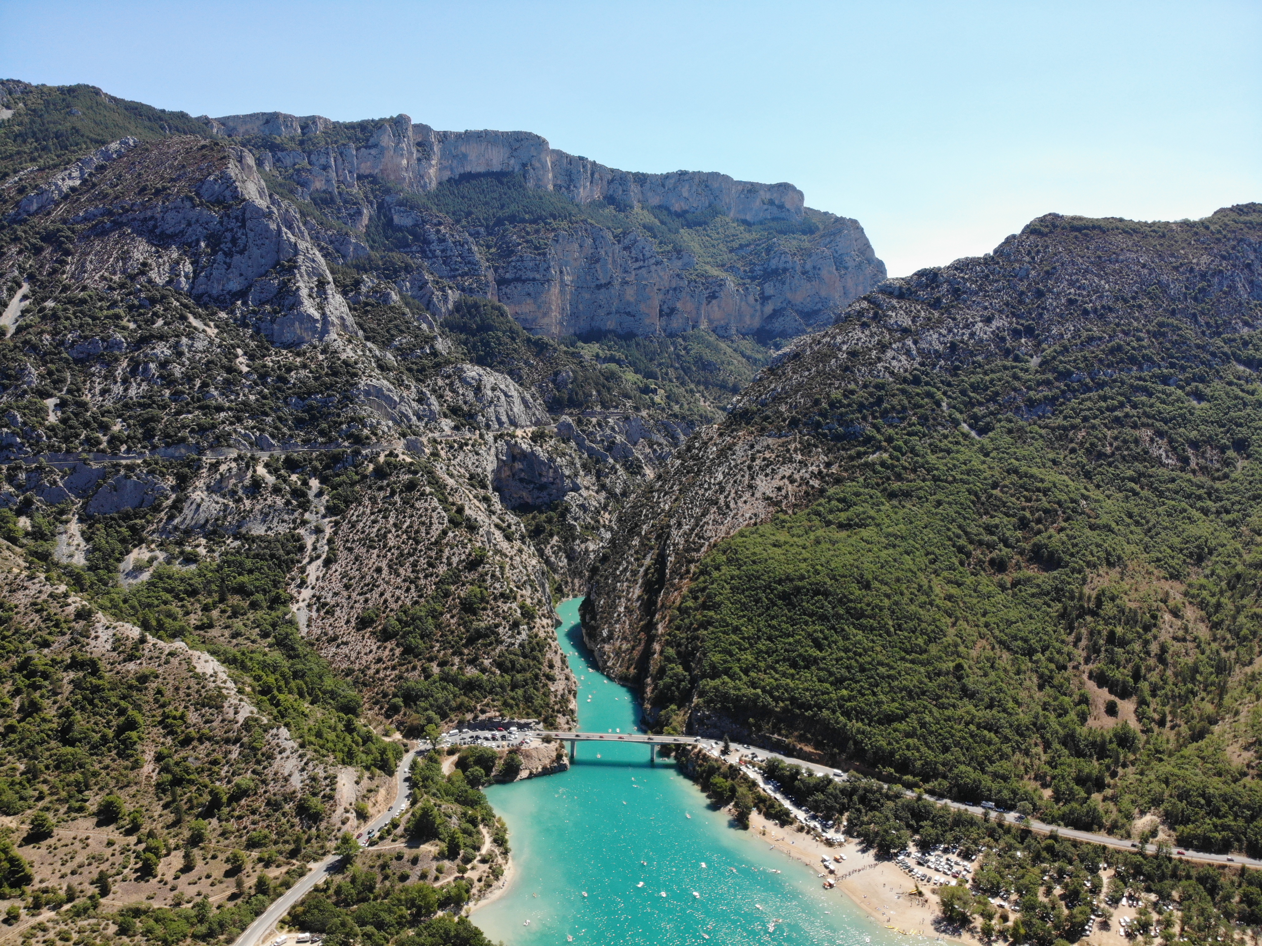
Verdon Gorge
The color is what stops you first. The Verdon River runs a shade of turquoise so vivid it seems artificial -- the result of glacial rock flour suspended in the water, minerals ground so fine they scatter light into wavelengths the eye reads as tropical lagoon rather than Provencal canyon. The river is named for this quality: verdon derives from vert, green. But the gorge it has carved through 25 kilometers of Jurassic limestone is anything but gentle. Walls plunge 700 meters from rim to riverbed, making the Gorges du Verdon the deepest canyon in France and one of the most dramatic landscapes in Europe.
Written in Stone and Time
The gorge's biography stretches back to the Triassic period, when Provence subsided beneath the sea, accumulating thick layers of limestone. During the Jurassic, warm shallow waters encouraged coral growth. The Cretaceous saw the land lift again, and the Alps began their long rise during the tertiary era, fracturing the ancient limestone into the valleys and ridges that define the landscape today. When the Quaternary ice ages arrived, glaciers scoured the terrain, and the meltwater rivers that followed carved with extraordinary force -- the Verdon's flow rate during peak erosion periods approached 2,000 to 3,000 cubic meters per second. The result is a canyon that narrows to just 6 meters wide at the river level while stretching up to 1,500 meters from rim to rim at the top. At a point called the Imbut, the river disappears entirely beneath massive rock structures, flowing underground before reemerging downstream.
The Explorers' Canyon
Despite its proximity to the Riviera, the gorge remained largely unknown outside France until the early 20th century. The first printed descriptions appeared in 1782 and 1804, and French tourist guides mentioned it by the mid-19th century. But systematic exploration did not begin until 1905, when Edouard-Alfred Martel arrived as an employee of the Southeast Electricity Company to survey the river for hydroelectric potential. On August 11, Martel led a team including explorer Armand Janet, schoolmaster Isidore Blanc, and several others on the first complete expedition through the canyon. Their arrival at the Pas de Galetas marked the moment the Verdon Gorge entered the modern world. The Sentier Martel, a hiking trail laid out in 1928 by the Touring Club de France and named in his honor in 1930, remains one of the most popular routes through the gorge.
Drowned Villages and Dammed Rivers
Between 1929 and 1975, five dams were built along the Verdon, creating reservoirs that transformed the landscape. The construction came at a cost. To create the Lac de Sainte-Croix, the village of Les Salles-sur-Verdon was destroyed in 1973 and rebuilt as a modern settlement higher up the valley -- making it, by one measure, the youngest village in France. The village of Castillon suffered a similar fate. Today the reservoirs have become part of the scenery, their turquoise waters blending with the natural river to create a series of lakes that draw kayakers, swimmers, and fishermen. In 2006, after 23 years of environmental advocacy, the French Council of State blocked a proposed high-voltage power line through the gorge, preserving the canyon's visual integrity. During the severe European drought of 2022, however, the river ran dangerously low, drying up entirely in some sections.
Limestone Playground
The Verdon Gorge has become one of Europe's premier destinations for outdoor sports. Rock climbers know it for over 1,500 routes on solid limestone, ranging from 20-meter sport climbs to multi-pitch epics exceeding 400 meters. The vertical walls that once kept explorers out now attract climbers from around the world. Kayakers paddle the turquoise river between towering cliffs. Hikers descend into the canyon on trails that pass through tunnels blasted from the rock and cross the river on narrow footbridges. Paragliders launch from the rim. The gorge splits three sections: the Pregorges from Castellane to Pont de Soleils, the deepest section from Pont de Soleils to the Imbut, and the lower canyon from the Imbut to the Pont du Galetas. Each has its own character, but all share the same impossibly colored river winding between walls of ancient coral limestone, carrying glacial memories to the sea.
From the Air
Located at 43.74N, 6.36E in the Provence-Alpes-Cote d'Azur region. The gorge is spectacular from the air -- a deep, winding gash in the limestone plateau with turquoise water visible at the bottom. The Lac de Sainte-Croix at the western end is a large, vivid blue-green reservoir that serves as an excellent landmark. Nearest airports: Castellane is a small town at the eastern end; Vinon-sur-Verdon (LFNF) is nearby. Best viewed at 5,000-8,000 feet AGL. The gorge runs roughly east-west between Castellane and Moustiers-Sainte-Marie.