Vermilion Cliffs National Monument
In 1996, a California condor spread its wings over northern Arizona for the first time in decades. The species, once reduced to just 22 individuals worldwide, had been reintroduced at Vermilion Cliffs precisely because this place is so empty of people and so full of sky. The monument sprawls across the Paria Plateau in Coconino County, hugging the Utah border, and it remains one of the most sparsely inhabited protected landscapes in the American Southwest. Virtually no permanent residents live here. Roads barely penetrate the terrain. The land belongs to the wind, the raptors, and the deep geological record written in hundreds of layers of colored stone.
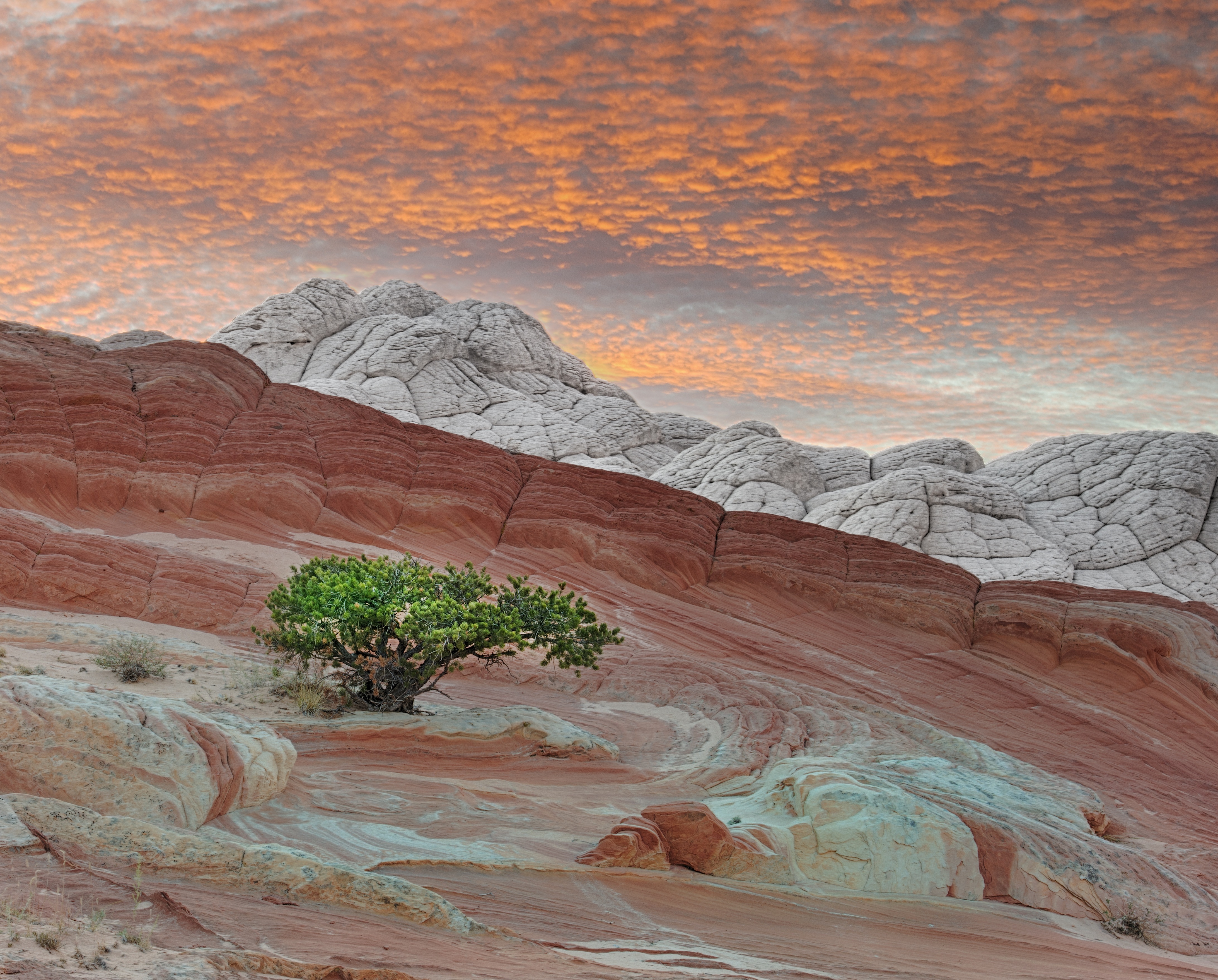
Walls of Fire
The Vermilion Cliffs themselves are steep eroded escarpments of sandstone, siltstone, limestone, and shale that define the monument's southern and eastern edges. Millions of years of erosion have sliced through these sedimentary layers, exposing hundreds of richly colored rock strata that shift from deep crimson to pale orange depending on the angle of the sun. Mesas, buttes, and broad tablelands rise above the plateau, interspersed with steep canyons where small streams sustain pockets of desert wildlife. Above it all, the Paria Plateau stretches flat and open northward from the cliff tops, a high desert expanse that feels like the edge of the known world.
Wings Over the Plateau
More than twenty species of raptors patrol the skies above Vermilion Cliffs, including bald eagles, golden eagles, peregrine falcons, and several hawk species. But the monument's most celebrated resident is the California condor, whose reintroduction here in 1996 marked a turning point in one of conservation's most dramatic recovery efforts. The remote location and absence of human habitation made it an ideal release site. On the ground, desert bighorn sheep, pronghorns, and mountain lions share the landscape with about thirty species of smaller mammals. In the monument's streams, rare fish like the flannelmouth sucker and speckled dace persist. Even the sand dunes harbor something precious: Welsh's milkweed, a threatened plant species known to exist only within the monument and one neighboring area in Utah, where it helps hold the shifting sands in place.
Twelve Thousand Years of Presence
Human settlement in this region stretches back 12,000 years. Hundreds of Native American pueblos are scattered across the monument, their stone houses, granaries, and burial sites still embedded in the landscape. The rock art here is extraordinary: Vermilion Cliffs contains one of the largest concentrations of petroglyph sites in any nationally protected area, and many of these carvings are believed to be among the oldest in the United States. The first European explorers arrived with the 1776 Dominguez-Escalante expedition, Spanish missionaries pushing into unmapped territory. Mormon settlers followed in the 1860s, and in 1871 they built one of the first ferry crossings on the Colorado River. That same year, John Wesley Powell passed through during his scientific explorations of the Colorado Plateau.
The Honeymoon Trail
Below the Vermilion Cliffs runs a wagon route with one of the more evocative names in Western history: the Honeymoon Trail. Mormon couples traveled this remote path to have their marriages sealed in the temple at St. George, Utah, then returned the same way. The route crossed country so rugged and isolated that it was otherwise seldom used, making it an intimate corridor through a vast emptiness. Historical markers now trace the trail's course beneath the cliffs. The monument itself was established on November 9, 2000, carved from existing federal lands and placed under the management of the Bureau of Land Management. Today, it remains what it has always been: a landscape defined by its remoteness, where the sky is wide, the stone is ancient, and the land resists easy access.
From the Air
Located at 36.81N, 111.74W in extreme northern Arizona, just south of the Utah border. The Vermilion Cliffs escarpment is a striking visual landmark from the air, with vivid red and orange rock bands visible against the pale Paria Plateau. Best viewed at altitudes of 5,000-8,000 ft AGL for cliff detail. Nearby airports include Page Municipal Airport (KPGA) approximately 30 nm east, and Kanab Municipal Airport (KKNB) approximately 40 nm northwest. The Navajo Bridge over Marble Canyon provides a useful navigation reference along the southern edge of the monument.