Versfeld Pass
Johannes Paulus Eksteen Versfeld -- John to everyone who knew him -- had nearly lost his children on the mountain more than once. The journey to the top of the Piketberg range, where fruit farms spread across the plateau, took four hours of dangerous, slow climbing on tracks that barely deserved the name. After one particularly harrowing trip, John went to the local government and asked them to build a proper pass. When they refused, he decided to build it himself.
A Shape in the Moonlight
The story of the pass's design belongs to a single night in 1889. John woke in the darkness, and in the moonlight glinting off his watch face, he saw a shape -- curves, loops, a pattern. He shouted into the quiet room: "That's it... That is what I will do with my pass!" The distinctive loops of the first Versfeld Pass were born from that moment of nocturnal inspiration. John supervised the construction himself, present every day from the start of the work to its completion. He missed only one day, for the birth of his son. The pass had to be rebuilt partway through after an initial construction error, bringing the total build time to three months. The gradient was steep -- 1:4 -- and the total cost came to 200 pounds, a sum equivalent to roughly 32,000 pounds today.
The Old Ossewa Pas
The original pass climbed to the west of what is now the R366 road, winding through a series of named turns that farmers and travelers came to know by heart. Nooi se Draai. Esels Draai -- Donkey's Turn. Moedverloor, a name that translates loosely as "lost courage." Vasvat Draai, meaning "hold tight." Korentebos. Die Baken. Klipoort. Each name tells a small story of the experience of climbing: the place where the donkeys balked, the spot where courage failed, the corner where you gripped the wagon seat and held on. At Valgrasskop, travelers looked up at the remaining climb. From Die Baken, they could finally see the plateau stretching ahead. The old pass -- the Ou Ossewa Pas, the old ox-wagon pass -- still exists as a hiking trail, its named corners preserved on weathered signs.
Armstrong's Modern Road
Motor vehicles began using the pass in 1926, and for seventeen years the road John had built for ox-wagons carried automobiles and trucks. By 1943, a farmer named Christopher Armstrong from Heldervue farm recognized that the old alignment could not serve modern traffic. He went to the local divisional council and made the case for a new pass. The reconstructed road was built four kilometers closer to the town of Piketberg, following a new alignment up the escarpment. In a gesture of respect, it was named Versfeld Pass in honor of John, who had built the first one with his own hands and his own money. The pass was widened in 1958 and again in 2017, each expansion acknowledging what the fruit farmers on the plateau already knew: the road up the mountain was the lifeline of their industry.
The Plateau Above
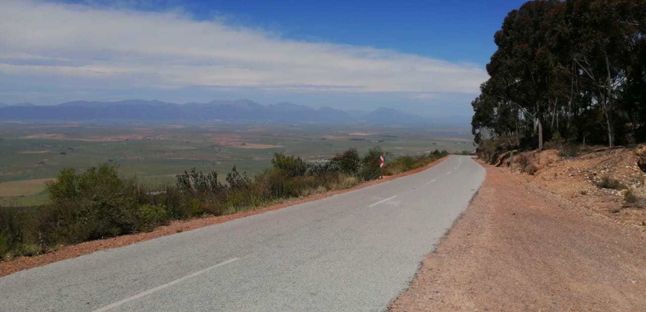
At 689 meters, the summit of Versfeld Pass opens onto a landscape that surprises first-time visitors. The Piketberg plateau, known locally as the Piket Bo-Berg -- the upper mountain -- is covered with fruit farms that benefit from the altitude's cooler temperatures and the reliable water that collects on the high ground. Viewpoints at the summit and midway up the pass offer sweeping views down to Voelvlei and across the Swartland plain toward the coast. The road is two lanes wide and still carries heavy agricultural vehicles, trucks loaded with the fruit harvest making their careful descent through the same mountain that once took John Versfeld's ox-wagons four hours to climb. The pass he built in three months made this agricultural community possible. The road that bears his name still sustains it.
From the Air
Versfeld Pass is at approximately 32.86S, 18.74E, climbing the western escarpment of the Piketberg mountain range to a summit of 689m. From the air, the pass is visible as a road with sweeping curves climbing the steep western face of the Piketberg. The plateau above is covered with orchards and farmland. Look for the R366 road running north-south along the base of the range, with the pass branching west and up. Voelvlei Dam is visible to the southeast. Nearest airports: Cape Town International (FACT, ~150km S). Piketberg town is at the base of the range. Beware of mountain weather and updrafts along the escarpment face.