Vettisfossen
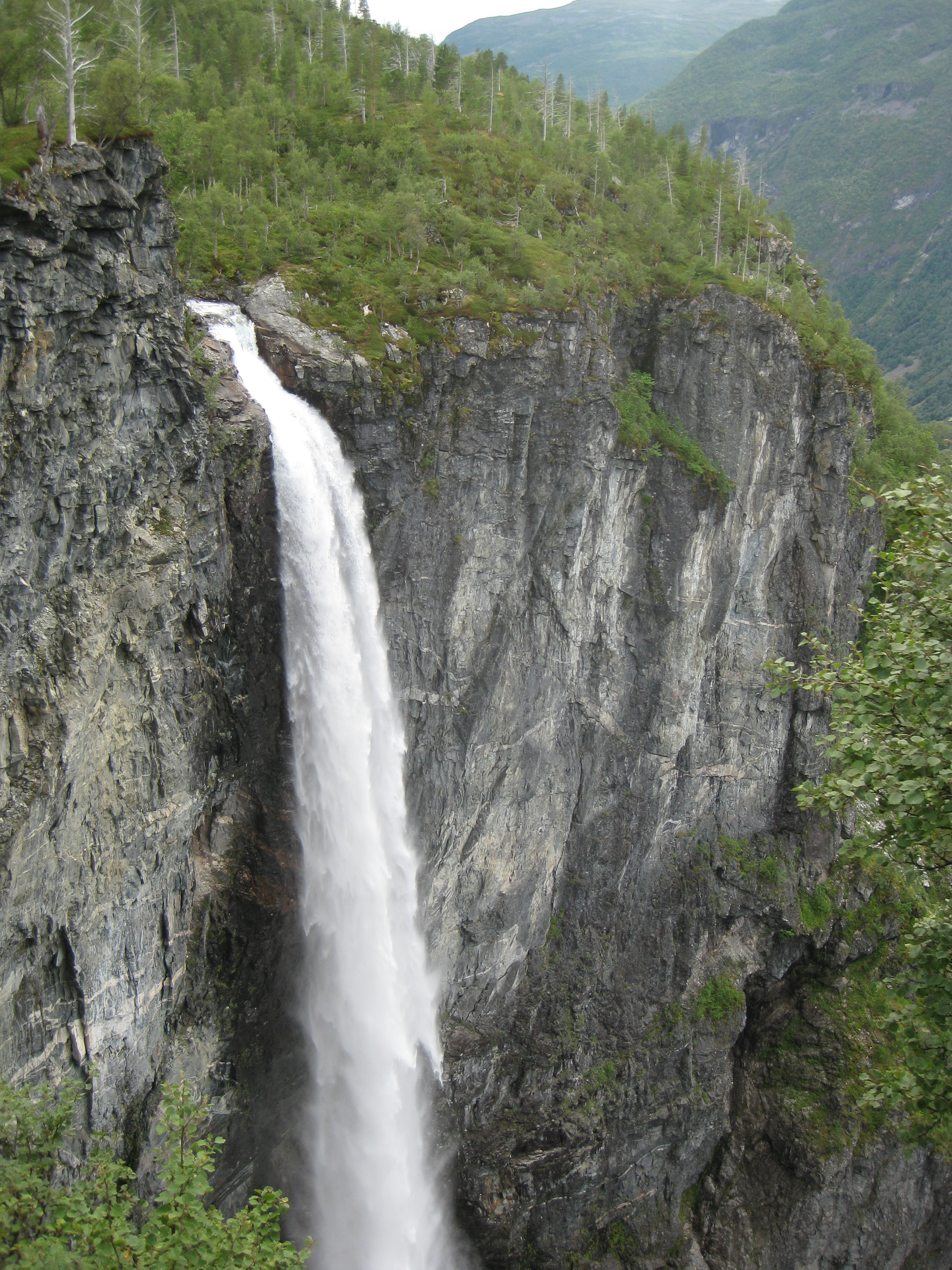
There is no parking lot at Vettisfossen. No viewing platform with a gift shop, no coin-operated binoculars, no paved path with handrails. To see Europe's tallest unregulated free-falling waterfall, you walk. The hike begins at the village of Ovre Ardal, follows the Utladalen valley upstream for two to three hours, and ends at a rocky outwash plain where the river Fosselvi crashes down from the cliff above. The waterfall drops 275 meters in a single, nearly vertical plunge, roughly 23 meters wide, throwing mist across the valley floor with enough force to drench anyone standing at the base. Locals describe the walk as easy, though the final kilometer from the Vetti farm to the falls turns rocky and steep. The reward is a waterfall that has never been dammed, diverted, or diminished by hydroelectric development, a rarity in Norway, where rivers have been the country's primary source of electricity for over a century.
The Scale of the Fall
Norway has hundreds of waterfalls, many taller than Vettisfossen by total height. But most of those taller falls are multi-tiered, cascading down rock faces in a series of steps and slides. Vettisfossen's distinction is its purity: a single drop, entirely free-falling, with no ledge or interruption between the lip and the pool below. At 275 meters, the water takes roughly seven seconds to reach the bottom, accelerating through air until wind resistance and the disintegration of the column into mist slow it. The flow varies with the season, fed by snowmelt from the Jotunheimen mountain range above. In late spring and early summer, when the melt peaks, the falls roar. By late autumn, the flow diminishes but never stops entirely. The waterfall feeds the river Fosselvi, which in turn flows into the Utla, the river that carved the Utladalen valley.
The Valley That Holds It
Utladalen is one of the deepest valleys in Norway, and the landscape on the approach to Vettisfossen reflects that depth. The trail follows the river through old-growth forest and past steep canyon walls, with the valley narrowing as it climbs. The Vetti farm, near the base of the falls, has occupied its shelf of level ground for centuries, one of those improbable Norwegian farmsteads clinging to a pocket of habitable land between vertical rock and rushing water. Above the falls, the mountain farm of Vettismorki perches on a ledge, historically accessed by a block-and-tackle system used to haul supplies and livestock up the cliff face. The entire area falls within the Utladalen Landscape Protection Area, a designation that shields the valley from the hydroelectric development that has transformed many comparable Norwegian valleys. The protection is the reason Vettisfossen still flows freely, a living remnant of what Norway's mountain rivers looked like before the turbines arrived.
Approaching the Falls
The trail from Ovre Ardal is well marked but earthy, passing through birch and pine forest along the banks of the Utla river. After roughly two hours of walking, the path arrives at the Vetti farm, where it is possible to buy refreshments in summer. From there, the terrain changes. The trail drops to the river and follows a rocky bank for about a kilometer to the outwash plain at the base of the falls. The waterfall itself is visible from the left side of the Fosselvi river, but seeing it properly requires being on the opposite bank. Crossing the river is strongly discouraged except during the absolute lowest flow periods, as the current is powerful and the rocks slippery. Most hikers content themselves with the view from the near bank, where the full height of the fall is visible and the spray reaches on windy days. In winter, the falls partially freeze, creating enormous ice columns that mountaineers occasionally attempt to climb, though access in deep snow makes the approach significantly more challenging.
A Waterfall Undiminished
Norway generates nearly all of its electricity from hydropower, and the development of the country's rivers has been one of the defining stories of its modern economy. Valleys that once thundered with free-flowing water now hold reservoirs and penstocks. Against that backdrop, Vettisfossen stands as an exception, a major waterfall in one of the country's most dramatic landscapes that has been left alone. The Utladalen Landscape Protection Area, established to preserve the valley's natural character, ensures that the falls will continue to drop their unbroken column of water into a valley that looks much as it did when the first farmers settled at Vetti. No turbine captures its energy. No dam controls its flow. The water falls 275 meters, hits the rocks, becomes a river, and runs down the valley toward the Sognefjord, following the same path it has followed since the glaciers retreated and left this landscape bare.
From the Air
Located at 61.38N, 7.95E in Ardal Municipality, Vestland county, within the Jotunheimen mountain range. The waterfall drops from a cliff face on the north side of the Utladalen valley. From the air, look for the white streak of water against dark rock in a deep, narrow valley surrounded by peaks exceeding 2,000 meters. Nearest airports: Sogndal/Haukasen (ENSG) approximately 50 km west, Fagernes/Leirin (ENFG) approximately 75 km east. Best viewed at 6,000-10,000 feet AGL in clear weather; the surrounding terrain is high and rugged.