Veurne
On the last Sunday of July, the streets of a small Flemish town fill with figures in long brown habits, hoods drawn over their faces, carrying wooden crosses as tall as they are. They do not speak. They walk slowly. Children watch from doorways. The procession is called the Boeteprocessie, the Procession of Penitents, and it has moved through Veurne every year since 1646, four centuries of identical footsteps. Behind the hooded figures come tableaux of biblical scenes, Roman soldiers, the Passion of Christ enacted across the cobblestones of the central market square. It is the only procession of its kind that has survived continuously in Flanders, and the market square it crosses is one of the most complete Renaissance ensembles in the country.
Furna
Veurne is old. It appears in writing in 877 as Furna, a property of the Saint Bertin Abbey in Saint-Omer, and around 890 it is already described as a successful fortification against Viking raids. The medieval castellany of Veurne, the territorial unit administered from this town, included forty-two parishes plus eight half-independent ones, all owing allegiance to the Count of Flanders. The town acquired city rights in the twelfth century, prospered from trade with England for a hundred years, then went into a long economic sleep when that trade collapsed in 1270. The nickname Veurne Sleepers, slapers, dates from that period. On 20 August 1297, the Battle of Veurne was fought somewhere outside town in the ongoing struggle between the Flemish cities and the French king, one more skirmish in a centuries-long argument over who owned this corner of the Low Countries.
The Procession Begins
The Capucines, a Franciscan reform order, organised a procession in 1644. Two years later the Sodales, a religious confraternity led by the Norbertine monk Jacob Clou, took it over and gave it the shape it still holds. The hooded brothers walked a cross-bearing penance during Advent. At the end of the seventeenth century the route expanded and acquired biblical tableaux. Joseph II of Austria, who closed monasteries and rationalised religious life across his domains, ordered the procession suspended in the 1780s. His brother Leopold II allowed it again in 1790. The French Revolution closed what cloisters remained. The procession persisted anyway, moved by the parish, carried by the town's identification with it. Today the hoods are worn by townspeople, the crosses are carried by neighbours, the route is the same fifteenth-century street plan.
Albert and Isabella's Town
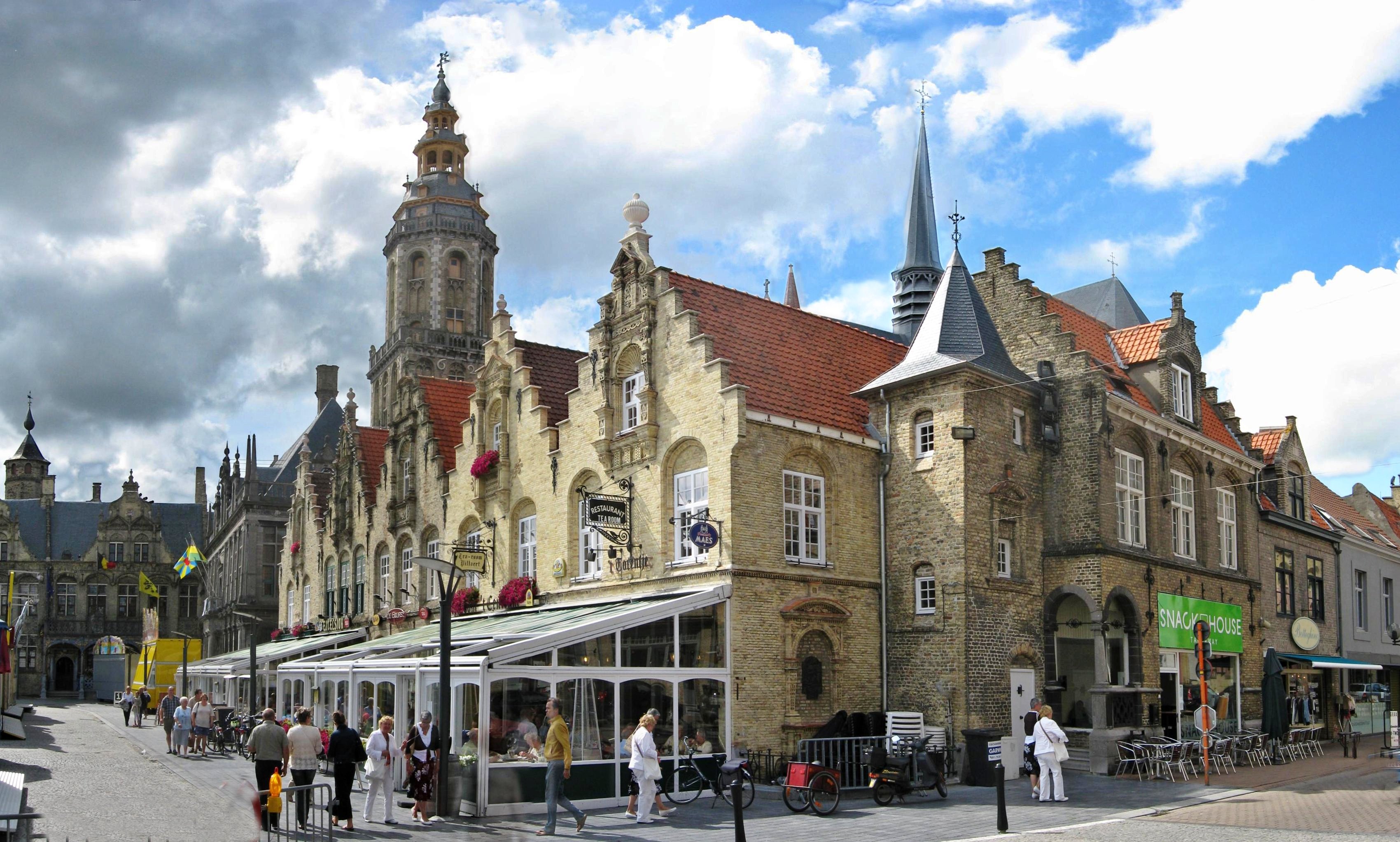
Most of the buildings on the Grote Markt date from the early seventeenth century, the prosperous reign of the Archdukes Albert and Isabella, joint sovereigns of the Spanish Netherlands around 1600. The pale local brick gives them a peculiar honey-coloured warmth in afternoon light, a different palette from the redder Flemish brick further north. The fifteenth-century city hall on the square is known as the Spanish Pavilion, having served as headquarters for Spanish officers in the seventeenth century. The nearby church of Saint Walburga, Gothic, predates the Renaissance ensemble. The Belfry was inscribed on UNESCO's World Heritage list in 1999 as part of the Belfries of Flanders and Wallonia (later extended to the Belfries of Belgium and France in 2005), recognised for its civic importance and architecture. Walk the square and you can read the town's prosperity in the dates carved over the doors.
King Albert's Headquarters
Veurne sat inside the Yser pocket during the First World War, the tiny sliver of Belgium that remained unoccupied after October 1914. The town hall became the headquarters of the Belgian Army under King Albert I, and a military hospital was set up in the city. Albert moved between his villa at De Panne and his command at Veurne for four years, the king of a country reduced to its westernmost towns and the soldiers willing to die for them. In 1920 the French president Raymond Poincare came in person to award the city the Croix de guerre with palm, a French military decoration extended to a Belgian town in recognition of what it had endured. Veurne is now an honorary holder of King Albert's name on its honorary citizens roll, alongside the Surrealist painter Paul Delvaux, who lived here for more than twenty years and died here in 1994.
The NATO Tower
Just outside town stands a thin grey lattice tower 243 metres tall, used for meteorological research and as a radio relay link. NATO built it during the Cold War. From the top of the Belfry on the market square you can see it across the polders, an aerospace-age punctuation mark in a landscape otherwise carrying buildings from the year 1600. The municipality also includes eleven deelgemeenten, rural villages with names like Bulskamp, Houtem, and Zoutenaaie, each a former parish folded into the modern town. The castle of Beauvoorde on the outskirts holds a collection of seventeenth-century furniture. The whole municipality has about eleven thousand seven hundred inhabitants. On the last Sunday of July, several times that number come to watch the hooded figures walk.
From the Air
Veurne lies at 51.0722 N, 2.6622 E, in the polderland of westernmost Belgium, 6 km inland from De Panne and the North Sea coast. From altitude the town is recognisable by its compact medieval core anchored by the Belfry tower and Saint Walburga's spire on the central market square. The Vauban fortifications around Veurne are still faintly visible as earthworks. The 243-metre NATO tower a short distance outside town is the tallest structure for many kilometres and a useful landmark. Closest airports are Ostend-Bruges (EBOS) 24 km northeast and Lille-Lesquin (LFQQ) 60 km south. Recommended viewing altitude 2,500 to 4,000 feet.