Viking Ring Fortress
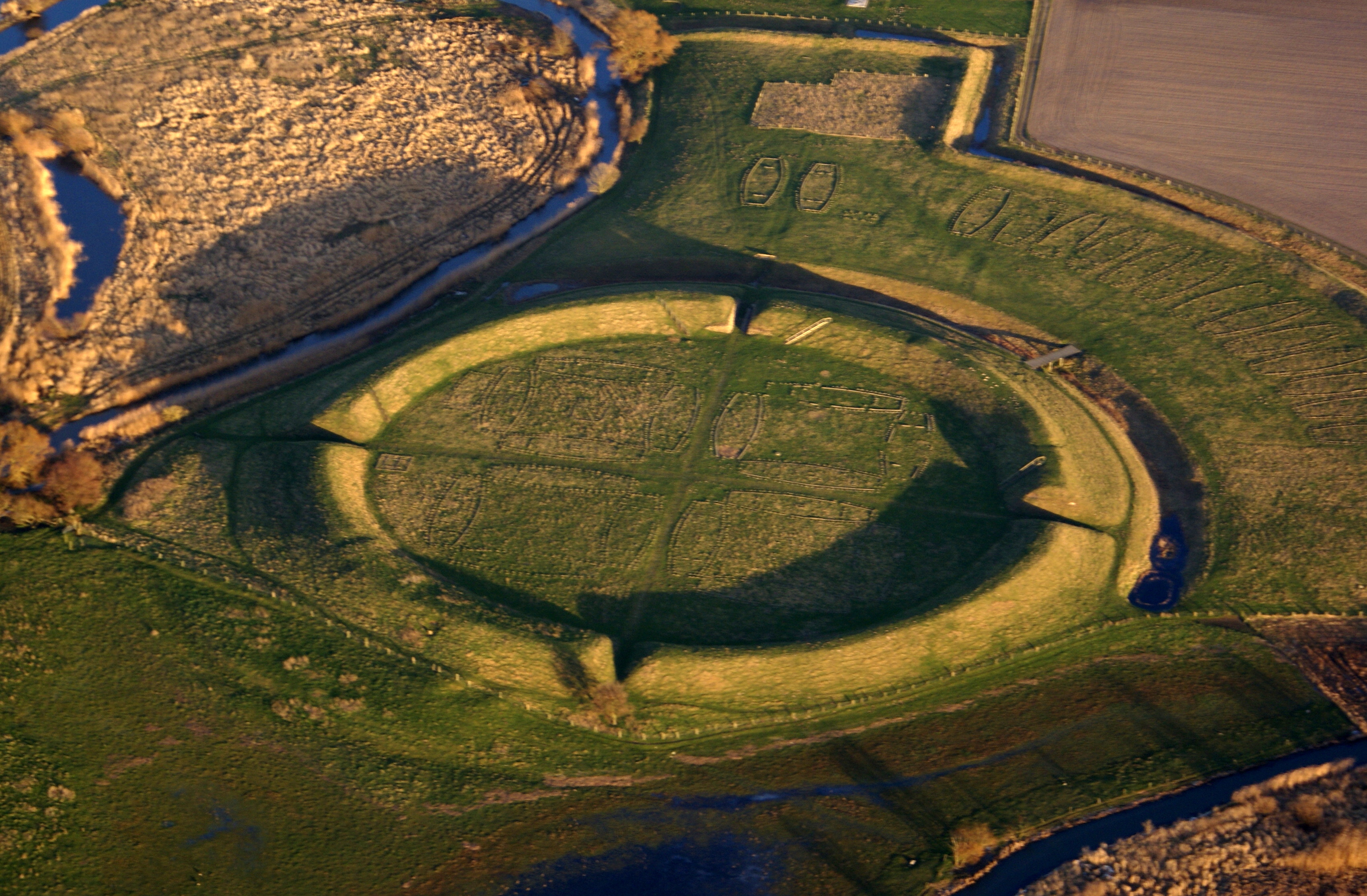
From the air, they look like crop circles with a purpose. Five perfectly circular earthworks, each with gates opening precisely to the four cardinal directions, each divided internally into four quadrants holding symmetrical blocks of longhouses. These are the trelleborgs, the Viking ring fortresses of Denmark, and they are among the most enigmatic structures of the medieval world. Built around 980 AD, abandoned within a generation, and never mentioned in any surviving text, they vanished into the Danish landscape for nearly a thousand years before archaeologists began pulling them back into the light.
Bluetooth's Chain
The fortresses belong to Harold Bluetooth, the Danish king who united Denmark and Norway and famously converted the Danes to Christianity. His reign, ending around 985 when his son Sweyn Forkbeard deposed him, was the apex of the Jelling dynasty. Dendrochronology has dated the timber at the original Trelleborg near Slagelse to the autumn of 980, with construction presumably beginning in the spring of 981. The five confirmed sites form a strategic chain stretching from Aggersborg at the northern tip of Jutland, southward across Funen to Nonnebakken at Odense, and east to Borgring on the coast of Zealand. Each fortress commanded a critical junction of land routes, waterways, or trade paths. Together they constituted something unprecedented in Scandinavia: a coordinated network of military infrastructure built to a single, precise blueprint.
Geometry in an Age of Longships
What makes the trelleborgs remarkable is not their size but their precision. Each fortress is strictly circular. The ramparts describe a perfect ring. Four gates align exactly with north, south, east, and west. Inside, longhouses are arranged in square blocks, one per quadrant at most sites and four per quadrant at Trelleborg. The symmetry is almost unsettling for structures built by a culture typically associated with raiding and saga poetry rather than compass work and urban planning. Some scholars have noted that the trelleborgs appear to have been measured using the Roman foot, and that the pointed V-shape of their moats echoes Roman engineering. Whether this reflects direct influence or convergent solutions to common problems remains debated. The name 'trelleborg' itself carries ambiguity: it may derive from the Old Norse 'thrall,' meaning slave, or from 'trel,' referring to the wooden staves that covered the rampart walls.
Purpose Unknown, Power Clear
No one knows exactly why Harold Bluetooth built them. The fortresses were used for perhaps five years, certainly no more than twenty, and show no signs of maintenance. Some historians argue they were military barracks or training grounds. Others see them as administrative outposts of a budding centralized state, places where royal authority could project itself across a territory too large for any single army to patrol. The most compelling theory, proposed by archaeologist Soren Sindbaek, suggests the fortresses served as shelters: local populations could retreat behind the circular walls while waiting for reinforcements from Harold's mobile forces. In this reading, the trelleborgs were not weapons but shields, allowing the king to control vast territory without stationing permanent garrisons everywhere. Whatever their purpose, their abandonment was as sudden as their construction. When Sweyn Forkbeard overthrew his father, the ring fortresses simply stopped being used.
A Thousand Years to Recognition
The modern rediscovery began in the 1930s, when the first Trelleborg near Slagelse was excavated between 1936 and 1941. Nonnebakken, buried beneath the medieval city of Odense, was the most contested site, not formally accepted as a trelleborg until 2017. It took geo-radar technology, applied in 2018, to reveal the structural remains hidden beneath centuries of urban development. Borgring, the most recently confirmed site, yielded a corresponding late-10th-century date in 2014. In 2023, all five Danish trelleborgs were inscribed on the UNESCO World Heritage List, recognized for their unique architecture and their testimony to the military power of the Jelling dynasty. They stand now as one of the Viking Age's most powerful legacies: not a saga or a runestone, but five circles drawn on the earth with a precision that still commands respect a millennium later.
From the Air
Located at 57.00N, 9.26E. The article describes five fortress sites across Denmark. Fyrkat (56.99N, 9.77E) near Hobro is the best-preserved for aerial viewing, its circular rampart clearly visible in cultivated farmland. Aggersborg (56.99N, 9.26E) near the Limfjord is the largest. Trelleborg (55.40N, 11.26E) near Slagelse on Zealand. Nearest airports include Aalborg (EKYT) for the northern sites and Copenhagen Kastrup (EKCH) for Trelleborg and Borgring. Best viewed at 2,000-3,000 feet to see the circular earthwork outlines against surrounding fields.