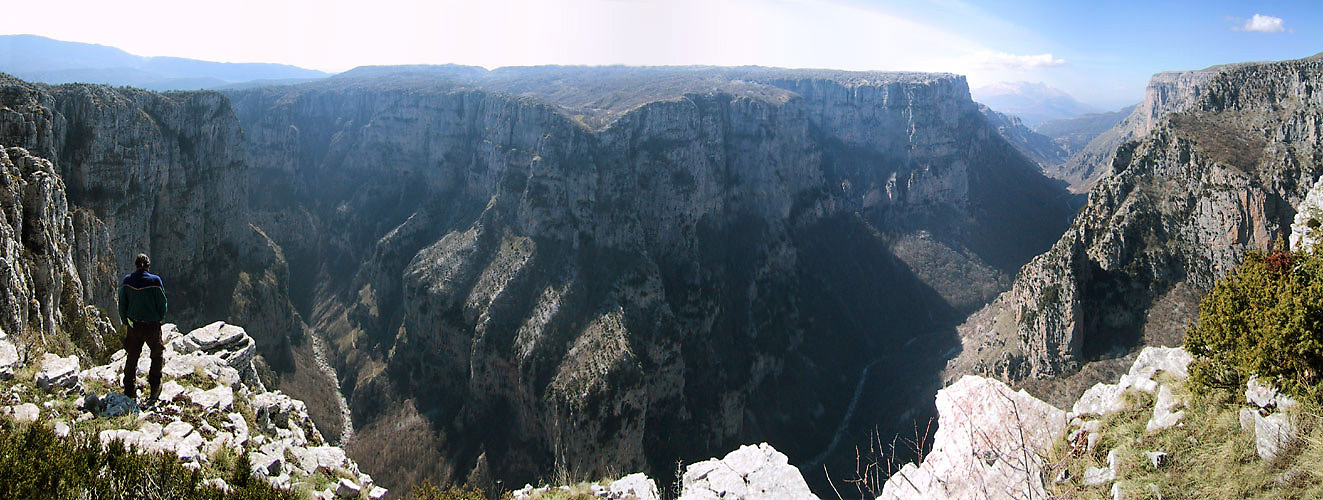
Vikos Gorge
Nobody agrees on what the name means, which feels appropriate for a place that defies easy description. Some linguists trace "Vikos" to a Slavic word for chasm. Others connect it to an ancient Greek term for a handled jar -- the gorge's shape and the echoes it produces suggesting a vast ceramic vessel. A third theory links it to an Albanian word for bridge, after an Ottoman-era wooden crossing that once spanned the canyon. The gorge itself settles the argument by being too large for any single word. Thirty-two kilometers long, up to 1,350 meters deep, and in places so narrow you could almost touch both walls, Vikos cuts through the southern slopes of Mount Tymphe in the Pindus Mountains of northwestern Greece. The Guinness Book of Records lists it as the world's deepest gorge relative to its width.
Carved by Ice and Water
The Vikos Gorge is not merely old -- it is a document of geological time measured in ice ages. The Voidomatis River basin contains evidence of three major glacial phases, the two largest occurring during the Middle Pleistocene. During those vast glaciations, ice covered the upland limestone terrain, and meltwater fed directly into the river channels because the underground karst drainage was choked with frozen sediment. Glacier snouts pushed close to modern valley bottoms. When the ice retreated, water went underground, dissolving the limestone and carving an elaborate system of caves and channels whose roofs eventually collapsed, creating the sheer cliffs and perpendicular walls that define the gorge today. The innermost alluvial deposits in the Voidomatis basin are limestone fragments carried down from higher elevations by glacial action roughly 30,000 years ago. The outermost deposits tell a different story -- they result from human-caused deforestation and soil erosion linked to pastoralism.
Stone Villages of the Zagori
The gorge lies in the core zone of the Vikos-Aoos National Park, in the Zagori region -- a landscape of stone-built villages, arched Ottoman-era bridges, and mountain footpaths that has been inhabited sparsely but continuously for millennia. The main gorge begins between the villages of Vitsa and Koukouli and ends near the village of Vikos. Monodendri, perched on the western rim, serves as the primary access point for hikers descending into the canyon. From the viewing platform at Oxia, eight kilometers by road from Monodendri, you look down into the deepest section. On the eastern rim, the village of Vradeto offers another perspective from the viewpoint at Beloi. Between these stone settlements, the 18th-century bridges near Kipi arch over tributaries with an engineering elegance that makes them look both ancient and inevitable.
The River That Disappears
Water behaves strangely in limestone country, and the Voidomatis River demonstrates this with theatrical flair. For most of the gorge's length, the streambed is seasonal -- dry for much of the year, flowing only after heavy rain. The river appears permanently only in the lowest section of the gorge, emerging from springs where an impermeable stratum forces underground water back to the surface. Above those springs, the karst drainage system swallows everything. Rainwater dissolves the limestone as it percolates downward, enlarging caves and channels until their roofs collapse, creating new cliffs and new passages in a cycle that has been running for hundreds of thousands of years. The scarcity of surface water is the gorge's central paradox: water carved this immense canyon, then mostly vanished into its own creation.
Healers and Chamois
The gorge's remoteness preserved both wildlife and traditional knowledge. Chamois -- the agile mountain goats of European cliffs -- still inhabit the higher reaches, particularly around Megas Lakos, a secondary ravine. They stay far above human activity, visible as specks moving across vertical rock faces. The Zagori region also produced a tradition of herbal healers who used medicinal recipes sometimes traceable to Hippocrates and Dioscorides. Mountain tea, brewed from Sideritis raeseri, remains a staple. St. John's wort, lemon balm, spearmint, and absinth all grow wild in the gorge's microclimates, and chemical analysis has confirmed that many of these native plants contain biologically active compounds. The healers' pharmacopoeia was not superstition -- it was empirical botany maintained across generations in a landscape too rugged and isolated for much else to take root.
Walking Through Deep Time
A hiking trail descends from Monodendri into the gorge and follows its length northward to the springs of the Voidomatis, where paths fork -- one leading to the village of Papingo on the north side, another to the village of Vikos on the south. You can also hike south from Monodendri to the stone bridges near Kipi. The trail passes through epipaleolithic history: artifacts from the Kleithi rock shelter on the Voidomatis banks date human presence here to the end of the last ice age. Between Monodendri and Vitsa, archaeologists have excavated a small Molossian settlement from the 9th to 4th centuries BCE, including stone houses and two cemeteries. For most of recorded history, though, the gorge was used for pastoralism and firewood -- a working landscape too steep for settlement, too useful to ignore. The scale is what stays with you. Standing at the bottom, looking up 1,350 meters of limestone wall, you are seeing the depth of time made vertical.
From the Air
Vikos Gorge lies at approximately 39.929N, 20.741E in the Pindus Mountains of northwestern Greece. The gorge runs roughly northwest to southeast for 32 km through the Zagori region. From the air, it appears as a dramatic slash through forested limestone terrain, with sheer white cliff walls visible against the green canopy. Mount Tymphe rises to the north. The stone villages of Monodendri, Papingo, and Vikos are visible on the rim. Ioannina National Airport (ICAO: LGIO) is the nearest airport, approximately 30 km to the south. The gorge is within the Vikos-Aoos National Park and is most dramatic viewed at lower altitudes where the depth and narrowness become apparent.