Villages with Fortified Churches in Transylvania
Of the roughly 300 fortified churches that once dotted the Transylvanian plateau, more than 150 still stand. They range from modest stone enclosures barely larger than a garden fence to elaborate multi-walled fortresses with gate towers, grain stores, and observation posts. In 1993, UNESCO selected seven of these villages -- six Saxon and one Szekely -- as a World Heritage Site, recognizing not just the churches themselves but the entire settlement pattern they anchor: compact villages clustered around a hilltop sanctuary, organized for defense and preserved by centuries of relative isolation. Flying over southern Transylvania, the pattern repeats itself across every valley: a church on a rise, red-tiled roofs radiating outward, fields beyond.
German Colonists on a Dangerous Frontier
The story begins in the twelfth century, when the Kings of Hungary invited German-speaking colonists -- the Transylvanian Saxons -- to settle the southeastern borderlands of their kingdom. The Saxons were granted special privileges: self-governance, trade rights, and the freedom to organize their communities according to their own customs. In return, they were expected to defend the frontier. It was not a theoretical obligation. Ottoman armies pushed north through the Balkans beginning in the fourteenth century, and Tatar raiding parties struck with devastating unpredictability. The Saxons responded with the tools they had. Towns like Sibiu and Brașov built full city walls. Smaller communities, lacking the resources for comprehensive fortification, turned to the one building every village possessed: the church. They added walls, towers, battlements, and storehouses, transforming parish churches into the Kirchenburgen -- church fortresses -- that became Transylvania's architectural signature.
Anatomy of a Church Fortress
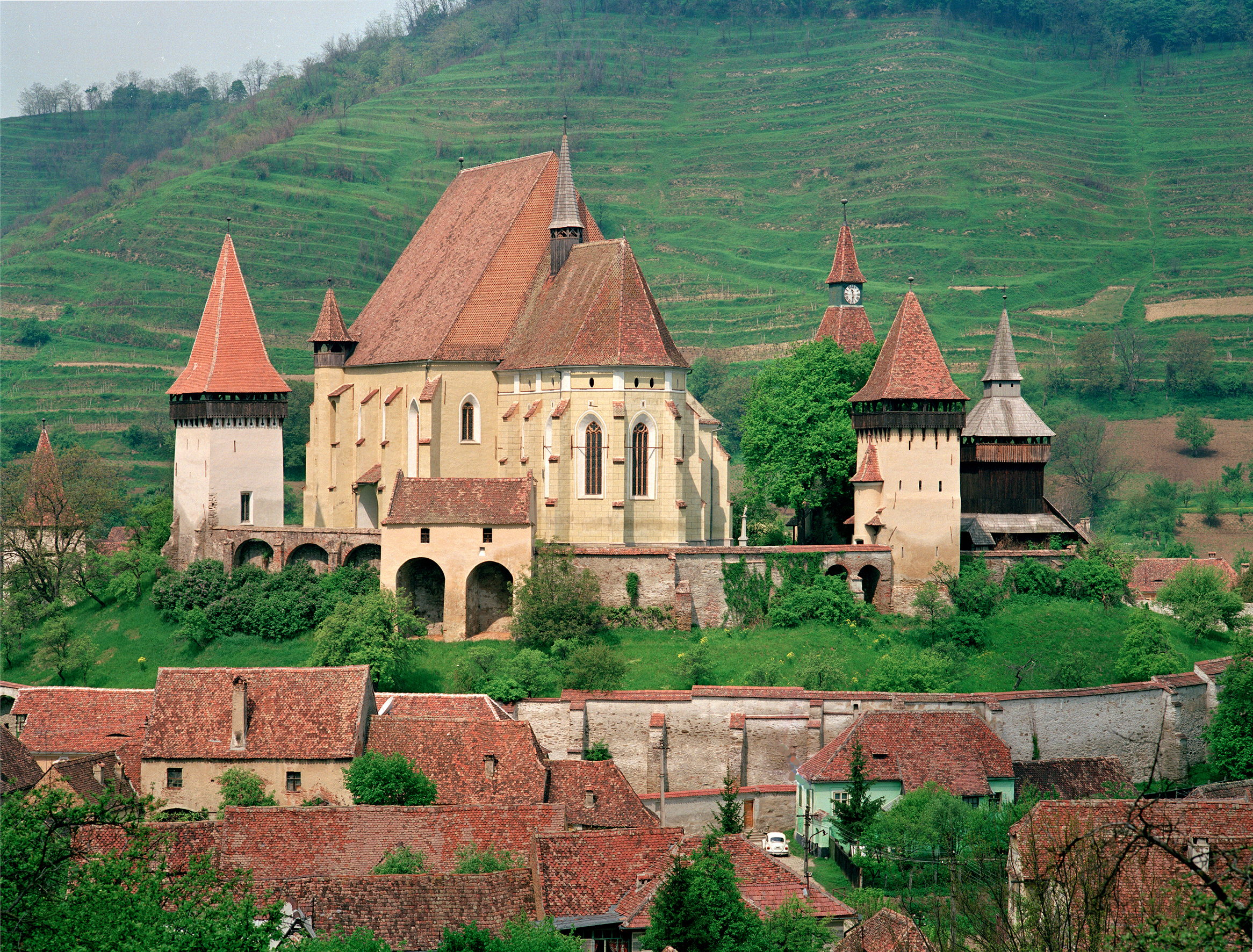
The fortified churches follow a recognizable pattern with local variations. The church itself, typically a Romanesque basilica or a late Gothic single-nave structure, sits at the center on elevated ground -- a hilltop wherever possible. Around it rise one or more rings of defensive walls, thickened by towers at corners and gates. Inside the walls, families maintained individual storage rooms stocked with grain, cured meats, and other provisions for withstanding a siege. Some complexes included a Tanzplatz -- a Dance Square -- that served as the village's communal gathering space. The parish house, schoolhouse, and village hall stood near the church, while wealthier families built their houses around the central square. Building materials were stone and red brick, roofed with the red clay tiles that remain characteristic of the region. Some towers served double duty as observation posts and clock towers; others housed chapels for minority confessions within the community.
Seven Villages, Seven Stories
The seven World Heritage villages represent a cross-section of the tradition. Biertan, with its triple ring of walls and nine gate towers, served as the seat of the Saxon Lutheran bishop for nearly three centuries. Viscri, a remote village that gained international attention after Prince Charles purchased and restored a house there, preserves a particularly intact fortified church ensemble. Prejmer, near Brașov, boasts the largest fortified church in southeastern Europe, with a massive enceinte containing over 270 individual storage rooms stacked in four tiers inside the walls. Dârjiu is the sole Szekely village in the group, its Unitarian church notable for fourteenth-century murals depicting the legend of Saint Ladislaus. Câlnic, Saschiz, and Valea Viilor round out the seven, each illustrating a different approach to the same fundamental problem: how to protect a community when the nearest army might be weeks away.
A Landscape Between Preservation and Loss
The Saxon population that built these churches has largely departed. After World War II, Romania's communist government confiscated Saxon property and suppressed their cultural institutions. When borders opened after 1989, most remaining Saxons emigrated to Germany, reducing a community that once numbered hundreds of thousands to a few thousand elderly residents. The churches they left behind now serve congregations that can sometimes be counted on two hands. Yet the buildings endure, maintained by a mix of Romanian and international conservation efforts. The Mihai Eminescu Trust, the Fortified Churches Foundation, and UNESCO-supported programs have stabilized structures that might otherwise have collapsed into the hillsides. The villages themselves are changing too, as Romanian families move into former Saxon houses and tourism brings new economic life. The fortified churches remain what they have always been: the center of gravity around which everything else orbits, even when the people who built them are gone.
From the Air
The UNESCO-listed villages are scattered across the southern Transylvanian plateau at approximately 46.14°N, 24.52°E (using Biertan as the reference point). From cruising altitude, the fortified churches are identifiable as prominent hilltop structures surrounded by compact village layouts. The seven sites span an area roughly 150 km east-west and 80 km north-south, between Sibiu (LRSB) and Brașov (LRBV). Târgu Mureș Airport (LRTM) serves the northern sites. The landscape is a plateau cut by the valleys of the Olt, Mureș, and Târnava rivers, with agricultural fields and scattered woodland between villages. Visibility is generally good in summer, with fog possible in river valleys during autumn and winter mornings.