Vindelfjällen Nature Reserve
Every four years or so, something extraordinary happens on the high tundra of northern Sweden. The Norway lemming population explodes, flooding the alpine meadows with small brown rodents, and the arctic fox -- one of Scandinavia's most endangered mammals -- finally breeds. This boom-and-bust rhythm drives the entire ecosystem of Vindelfjällen, a nature reserve so vast it could swallow a small European country. Covering more than 5,600 square kilometers of Swedish Lapland, Vindelfjällen is the largest nature reserve in Sweden and one of the largest protected areas in all of Europe. Its name comes from the Vindel River, which meanders through the mountains -- vindill, an old word meaning to turn or change direction, a fitting description for a waterway that twists through valleys carved by glaciers over millennia.
A Landscape of Extremes
The reserve spans nearly every type of Scandinavian mountain terrain. At its heart rises the Norra Storfjället range, whose highest point, Norra Sytertoppen, reaches 1,768 meters and marks the roof of Västerbotten County. The deep, symmetrical slash of the Syterskalet valley cuts through these peaks, sometimes compared to the famous Lapporten for its dramatic profile. Surrounding this alpine core, rolling plateaus and lower ranges radiate outward: Artfjället to the west, Ammarfjället at the center, Björkfjället along the northern boundary. Moving east, the mountains yield to primary coniferous forests that have never been logged -- some 500 square kilometers of old-growth taiga added to the reserve in 1988 specifically because of their ecological value. The climate shifts dramatically across this terrain. The western slopes catch moisture from the Atlantic, while the eastern valleys sit in rain shadow, creating a patchwork of wet alpine meadows and drier continental forest within a single protected area.
The Fox That Waits for Lemmings
Roughly 200 arctic foxes survive across the entire Scandinavian mountain chain, and Vindelfjällen is one of their most important strongholds. These small canines depend almost entirely on lemming population explosions to reproduce successfully, a precarious arrangement that has placed them on Sweden's critically endangered list. The Björkfjället and Artfjället ranges harbor the reserve's densest populations. Researchers from Stockholm University have studied them for decades through the SEFALO project, trying to understand why protection alone has not been enough to restore their numbers. The answer lies partly in competition: the red fox has been expanding into higher altitudes, pushing the arctic fox from territories it once dominated unchallenged. Beyond the foxes, the reserve hosts wolverines, Eurasian lynx, brown bears, and over 20,000 semi-domesticated reindeer belonging to three Sami communities. The wetlands around Lake Tärnasjön -- a designated Ramsar site -- and the Marsivagge Valley shelter roughly 120 nesting bird species, from golden eagles circling above the peaks to red-necked phalaropes spinning on shallow pools.
Nine Thousand Years of Footprints
Humans arrived here as the ice retreated, perhaps 9,000 years ago. The ancestors of today's Sami people hunted reindeer using pitfall traps -- pits two meters deep, spaced twenty to thirty meters apart, concealed with grass and likely fitted with spikes. Several trap complexes survive within the reserve, most positioned at the treeline where migrating reindeer passed predictably. Quartz shards and arrowheads near Tjulträsk, stone knife fragments south of Tärnasjön, and foundations of ancient dwellings at lakes Biellojaure and Överuman date back four to five thousand years. Ten Sami graves have been discovered, often placed on elevated ground commanding a view of the surrounding landscape. Some were set on small islands in Lake Tärnasjön, likely to protect them from scavenging animals. Sacred sites, called sieidi, appear in place names throughout the reserve -- words like Ailes, Saivo, or Akka signal spiritual significance. Near Lake Överst-Juktan, a wooden idol found in a rock crevice now sits in Stockholm's Nordic Museum, evidence of a sacrificial practice that once shaped the Sami relationship with this land.
Rivers Worth Fighting For
In the 1950s, Sweden's hydroelectric industry eyed the Vindel River. The ensuing battle between development and conservation produced the 1961 'Peace of Sarek' -- a compromise that sacrificed some rivers, including the nearby Ume, to protect others. The Vindel escaped the dams. In 1974, the reserve was formally established, covering the mountainous watershed. In 1993, the entire Vindel River was declared a nationalälv, a national river permanently shielded from hydroelectric development along with the Torne, Kalix, and Pite rivers. The protection debate has not ended. In 2008, the Swedish Environmental Protection Agency proposed upgrading Vindelfjällen to national park status, which would have provided the highest legal protection available. Local residents pushed back, worried that stricter rules would curtail snowmobiling, hunting, and fishing. Meanwhile, a Canadian mining company had already secured exploratory drilling permits within the reserve in 2009, exposing a gap in the original regulations. The drilling disrupted Sami reindeer herding, and though compensation was ordered, it went unpaid for years. The tension between use and preservation continues to define this place.
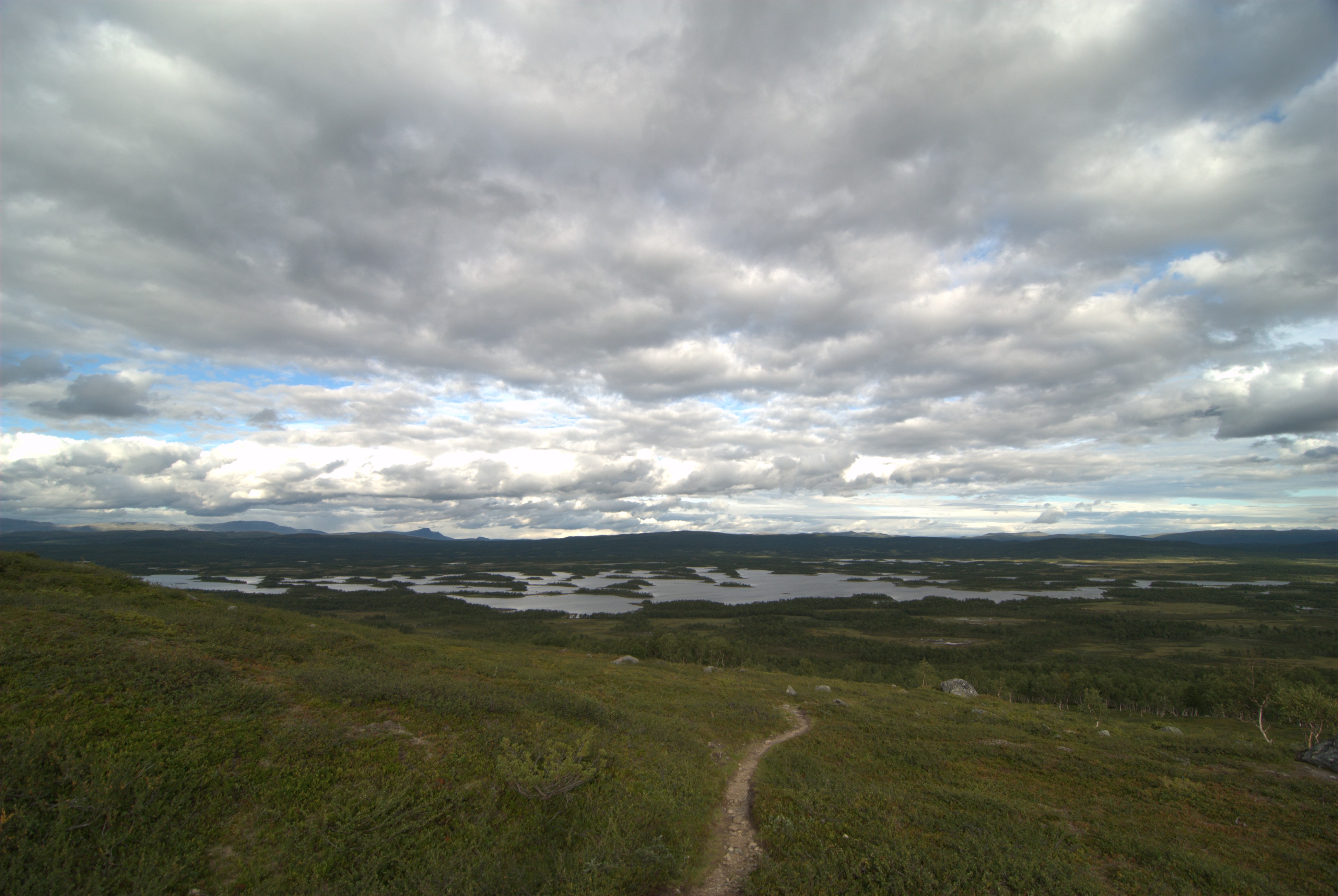
Walking the King's Trail
The Kungsleden hiking trail threads through Vindelfjällen between Hemavan and Ammarnäs, part of a route that stretches across the Swedish mountains. But many of its paths predate tourism by centuries. The priest serving the Jillesnåle chapel once walked seventy kilometers to reach Tärnaby for services, wearing a track into the landscape that hikers still follow. Another trail from Ammarnäs follows the Vindel River valley to the Norwegian border at Mo i Rana -- the same route nineteenth-century Norgefarare used to haul fifty-kilogram loads of cheap Norwegian groceries back to their struggling communities. Josef Berglund of Ammarnäs became a local legend for these grueling hundred-kilometer journeys. Today the reserve maintains roughly 600 kilometers of marked trails, over 40 bridges, and 23 cabins. The successive bridges crossing the island archipelago at the southern end of Lake Tärnasjön have earned the nickname 'Vindelfjällen's Golden Gate.' In Ammarnäs and Hemavan, visitor centers introduce newcomers to a landscape where the oldest hiking tradition belongs not to recreational walkers but to the Sami, whose transhumance routes cross the same mountains their ancestors first walked when the ice retreated.
From the Air
Located at 65.91°N, 15.88°E in Västerbotten County, Swedish Lapland. The reserve is enormous -- roughly 90 km east-west and 60 km north-south. From altitude, look for the dramatic Norra Storfjället range (1,768 m peak) at the center, the deep Syterskalet valley, and the extensive lake system including Tärnasjön with its island archipelago. Nearest airports: Hemavan/Tärnaby Airport (ESUT) on the western edge, and Vilhelmina Airport (ESNV) to the southeast. The E12 highway ('Blue Route') cuts through the reserve, visible as a line bisecting the western portion.