Vitória, Espírito Santo
When Portuguese settlers abandoned Vila Velha in 1551 and crossed the bay to set up a new capital on a defensible island, they called the new settlement Vila Nova do Espírito Santo - New Village of the Holy Spirit. Then they fought a battle against the Goytacaz people and won. They renamed their village Vitória - Victory. The Tupi name for the island had been Guanaani. The Portuguese name stuck. Today, Vitória is the third oldest state capital in Brazil, after Salvador and Recife, and the smallest in land area among all 27 Brazilian capitals. The island it sits on used to be fifty islands. Landfills did the rest.
The Island That Ate Its Neighbors
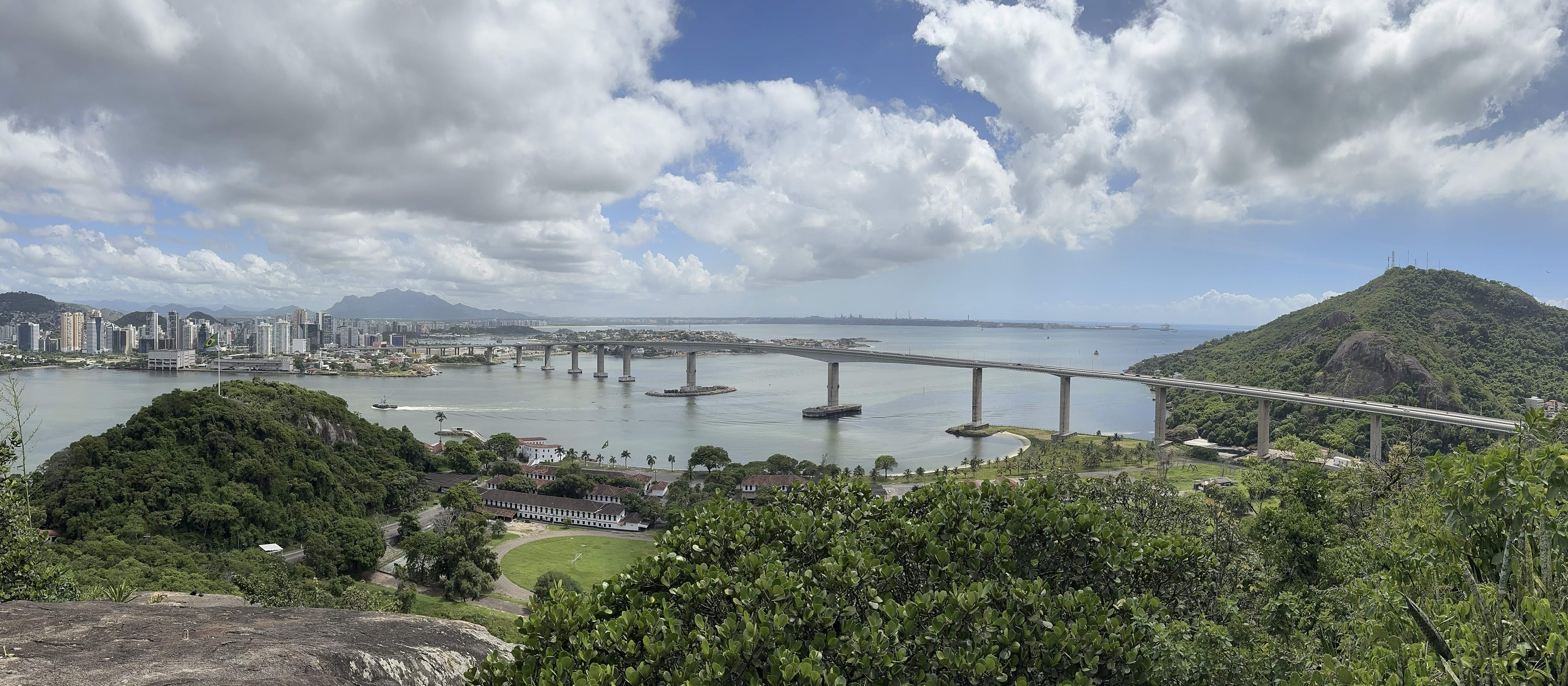
Vitória's main island is the anchor of an archipelago of 34 islands plus a small continental portion, totaling 93.38 square kilometers. Once there were 50 islands. Beginning in 1894, during Brazil's coffee boom, landfills began joining smaller islands to the larger one, opening flat ground for new neighborhoods and wider avenues. The first bridge connecting the island to the mainland opened in 1927, followed by the first harbor pier in 1941. Today the Deputy Darcy Castelo de Mendonça Bridge - locally called the Terceira Ponte, or Third Bridge - is the second tallest bridge in Brazil, arcing across the bay to connect Vitória with Vila Velha. The old pattern of narrow streets on the high ground, and fortresses along the coast where lowland attacks came from, still shows in the street grid of Cidade Velha, the Old City.
Iron Ore and Soybeans
Vitória's economy rides on the shoulders of two ports. The Port of Vitória is the most difficult port in Brazil for ships to reach - the bay is narrow, hemmed in by rocks and hills, and ships, cars, and people compete for the limited space. Today it mostly handles cruise ships and ship repairs. The Port of Tubarão, designed in the 1960s by the mining giant then called Companhia Vale do Rio Doce, opened in 1966 to relieve the choke. Tubarão now handles 80 million tonnes a year, originally built to export iron ore mined in Minas Gerais and brought to the coast by the Vitória-Minas Railway, and more recently fitted with silos for grain and soybean meal. Together, these ports made Vitória Brazil's leading capital for tonnage handled and gave it the highest GDP per capita among all Brazilian capitals.
Fonte Grande and the Peak Far Away
The central massif of Vitória's main island, Morro da Fonte Grande, rises 308.8 meters above sea level - a granite outcrop now protected as Fonte Grande State Park, with hiking trails through Atlantic Forest regrowth in the middle of the city. Two other granite knobs - Pedra dos Dois Olhos at 296 meters and Morro de São Benedito at 194 meters - complete the island's rocky skyline. But Vitória's actual highest point sits 1,100 kilometers offshore: the Pico do Desejado on Trindade Island, 601 meters tall, on a distant volcanic archipelago that the municipal government administers along with the sister island of Martim Vaz. Meteorological stations on Trindade and Martim Vaz provide crucial data because the islands sit in a zone of air mass dispersion in the South Atlantic.
Fourth Best City to Live In
In 1998, the United Nations rated Vitória the fourth best state capital to live in Brazil. In 2013 it finished again at fourth best. Among Brazilian capitals, Vitória still holds the second best Human Development Index, behind only Florianópolis, and its per capita income is the highest of any Brazilian capital. It also has the smallest population of any state capital in the southeastern region - 322,869 residents per the 2022 census, on an island small enough that you can drive its length in 20 minutes. The rest of the metro area - 1.88 million people across Serra, Cariacica, Vila Velha, Fundão, Guarapari, and Viana - squeezes around the island like a body around a beating heart. The racial makeup reflects Brazil's mix: 45.6% white, 41.6% pardo (mixed race), 12.4% Black, 0.4% Asian or Indigenous.
Colonial Survivors
Most of Vitória's colonial and imperial architecture was demolished in the 20th century push to modernize, but some buildings remain. The Chapel of Santa Luzia, built in the 16th century, is the oldest structure in the municipality. The Church of São Gonçalo dates from 1766. The Church of the Rosary was built in the 18th century. The Church and Convent of Carmo was founded in 1682 by Carmelite priests. The Metropolitan Cathedral of Vitória, begun in the 1920s, presides over the historic center. The Anchieta Palace, the state governor's official residence, rises on the same hill where Jesuit priests built their first mission. The Fort of São João once stood where the Saldanha da Gama Rowing Club now sits - the lowlands of the island used to need fortresses because the high ground needed protection.
From the Air
Vitória sits at 20.32°S, 40.30°W on a small island at the mouth of Vitória Bay, with three major bridges connecting it to the mainland. From cruising altitude, look for the distinctive island-in-bay geometry, the iron ore piles at the Port of Tubarão just north, and the white silhouette of the Penha Convent across the bay in Vila Velha. The Third Bridge (Terceira Ponte), Brazil's second tallest bridge, is an unmistakable arc crossing the bay south. Nearest airport is Eurico de Aguiar Salles International (SBVT), on the island itself near Camburi Beach. Best viewed in morning light when the ocean side glows and the granite domes of Fonte Grande stand out against the urban grid.