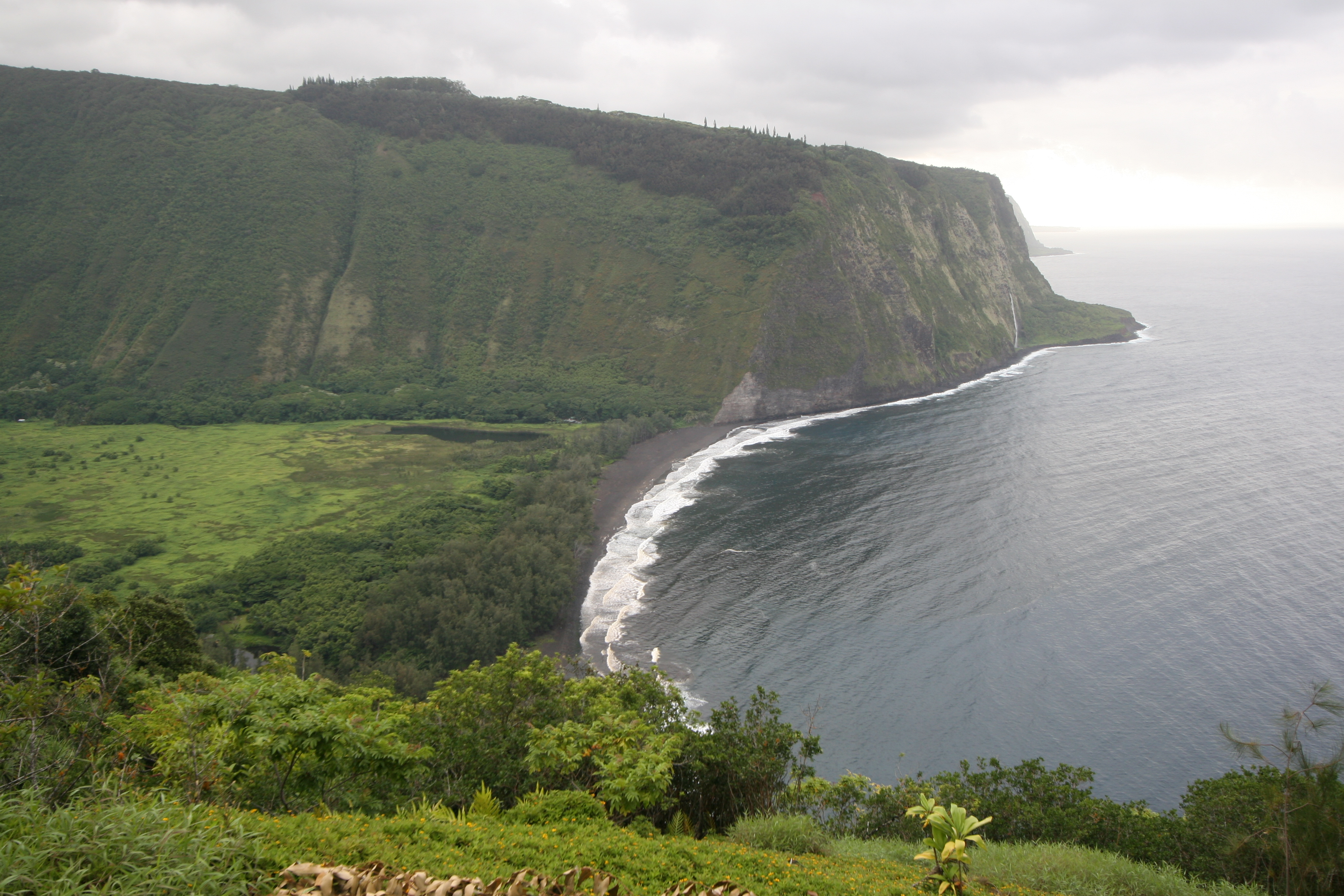
Waipiʻo Valley
Hawaiian tradition holds that the sand covering the floor of Waipiʻo Valley conceals the entrance to Lua-o-Milu, the realm of the dead. Whether or not you believe in hidden underworlds, the valley itself feels like a passage into another era. Nearly 2,000 feet below the surrounding plateau on the Hamakua Coast of Hawaiʻi Island, this mile-wide amphitheater of green cliffs and cascading water was once the political and spiritual heart of the Hawaiian kingdom. Its name, meaning "curved water," barely hints at what waits below.
The Valley of Kings
For centuries, Waipiʻo served as the capital of Hawaiian aliʻi. The first chief to hold court here was Kahaimoelea, and the valley remained a seat of power through the reign of King Umi. At its peak, an estimated 10,000 people lived on 800 acres of irrigated taro, the staple crop that fed the kingdom. Sacred nioi trees stood near the ancient grass palace, earning the site the name Nioi wela o Pakaalana — "The burning Nioi of Pakaalana." In the 18th century, Kahekili II of Maui raided the valley and burned those four sacred trees to the ground, an act of desecration that still resonates in oral histories. The valley’s importance was spiritual as well as political: this was where heaven and earth were believed to meet, where chiefs could commune with ancestral power.
Where the Waterfalls Begin
Several massive waterfalls feed the river that winds through the valley floor before emptying into the Pacific. The most dramatic is Hiʻilawe, one of the tallest free-falling waterfalls in Hawaiʻi, plunging from the back wall of the amphitheater in a white ribbon that seems to materialize from the clouds. The valley was carved by stream erosion cutting through the relatively soft basalt lava of the extinct Kohala volcano, a process that took hundreds of thousands of years to sculpt these sheer walls. Where the river meets the ocean, a black sand beach stretches across the valley mouth, its dark grains ground from volcanic rock by the relentless surf. Surfers paddle out here into waves that break against a coastline virtually unchanged since Polynesian voyagers first saw it.
The Steepest Road in America
Getting into Waipiʻo is an adventure in itself. The access road drops 800 feet in just 0.6 miles, averaging a 25% grade with sections reaching up to 45% — steep enough to make it arguably the steepest road of its length in the United States. Only four-wheel-drive vehicles are permitted, and access to the valley floor is restricted to Big Island residents, permitted tour operators, and those exercising Native Hawaiian traditional and customary rights. For those willing to go further on foot, the Waimanu (Muliwai) Trail leads over the ridge to the even more remote Waimanu Valley, accessible only by this trail or by boat. The trek crosses Waimanu Gap at 2,089 feet elevation before descending into a valley that sees few human visitors.
A Living Valley, Still Changing
Waipiʻo is not a museum piece. A handful of taro farmers still work the valley floor, cultivating the same crop that sustained thousands of Hawaiians centuries ago. The 2006 Kiholo Bay earthquake reminded everyone that this landscape remains geologically active: a cliff at the valley entrance collapsed into the ocean, and rockfalls blocked the access road. The valley served as the filming location for the final scene in the 1995 film Waterworld, standing in for the mythical "dry land" the characters had been seeking — a fitting role for a place that has represented paradise and otherworld in Hawaiian imagination for far longer than Hollywood has existed. Even today, the valley’s isolation keeps it feeling like a world apart, where the sound of falling water drowns out everything but the wind.
From the Air
Located at 20.12°N, 155.59°W on the northeast (Hamakua) coast of Hawaiʻi Island. The valley is a dramatic 1-mile-wide notch visible from altitude, with sheer green cliffs dropping nearly 2,000 feet to the valley floor. Best viewed from 2,000–4,000 feet AGL approaching from the northeast. The black sand beach at the valley mouth is a clear landmark. Nearby airports: Waimea-Kohala Airport (PHMU) approximately 15 nm southwest; Hilo International Airport (PHTO) approximately 35 nm southeast. Trade wind clouds often gather along the Hamakua Coast, so morning offers the best visibility.