Waithali Kingdom
A stone inscription carved in 729 AD, written in Sanskrit rather than the Burmese that surrounded it, lists a dynasty of kings beginning with one named Bahubali. It claims these rulers traced their blood to the Hindu god Shiva, yet it also records that Mahayana Buddhism flourished throughout their realm. This is the Anandachandra inscription, and the kingdom it describes, Waithali, was a place where contradictions were not contradictions at all but simply the way things worked on the coast of Arakan.
Successor to a Fading Power
Around 370 AD, the Dhanyawadi kingdom, the first major polity in the Arakan region of present-day Rakhine State, began to fade. Power shifted to a new capital called Vesali, the name by which Waithali was also known, built along a tidal creek and enclosed by brick walls. The city's layout reflected substantial Indian influence, a pattern that would deepen over the centuries. Waithali's territory extended across the Kaladan and Lemro River valleys and reached as far as Chittagong in what is now Bangladesh, making it a kingdom that straddled the boundary between South and Southeast Asia. Of all the early Arakanese kingdoms, historians consider Waithali the most Indianized, a cultural bridge between two worlds.
Where the Trade Routes Crossed
Geography made Waithali wealthy. Positioned along the major maritime routes connecting China and India, the kingdom became a hub where ships arrived annually at its peak, carrying goods between the Pyu city-states and China to the east and India, Bengal, and Persia to the west. The Mon people traded through Waithali's ports. So did merchants from across the Bay of Bengal. This was not a backwater kingdom clinging to a riverbank; it was a node in an international network that linked civilizations from the Mediterranean to the South China Sea. The economy thrived on this transit trade, and the city grew accordingly, its brick walls expanding to accommodate the wealth flowing through.
Shiva's Descendants, Buddha's Followers
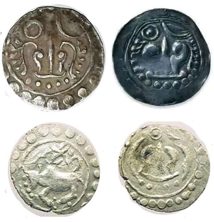
The Chandra dynasty governed Waithali, and the tension at the heart of their rule was religious. The kings claimed descent from Shiva, suggesting Shaivite roots, yet Mahayana Buddhism dominated the kingdom's spiritual life. A large stone bull discovered at the center of a brick structure hints at the Brahmanic rituals that persisted in courtly tradition alongside Buddhist practice. Coins bearing the Sanskrit name of King Vira Chandra show a bull on one side and the Srivatsa symbol of prosperity on the other, designs that echoed those found in contemporary Pyu cities, in Thailand, and as far away as southern Vietnam. This blending was not unusual in the region, but at Waithali it found particularly clear expression: a dynasty that worshipped one way, governed another, and saw no conflict between the two.
Written in Stone and Pillar
Two inscriptions anchor what historians know about Waithali. The Anandachandra inscription, its 72 lines of Sanskrit text spread across 51 verses on the western face of the stone, chronicles the rulers who preceded King Anandachandra. Analyzed by Dr. E. H. Johnston, the inscription is unique within Myanmar, where Sanskrit was otherwise rarely used, and it alludes to political and religious connections stretching to Sri Lanka and the Andhra region of India. A second inscription, preserved on a pillar now housed in the Shitthaung Temple at Mrauk U, provides a detailed dynastic record of the Sri-Dharmarajanuja line, listing nineteen kings and their respective periods of rule. Together, these records transform Waithali from an archaeological footnote into a documented kingdom with names, dates, and ambitions.
Walls Within Walls
Like the Pyu cities of central Myanmar, Waithali was built with an inner walled area enclosed by an outer city wall. The space between was likely used for agriculture by the lower classes, a practical arrangement that also served as a buffer zone in times of conflict. King Bhutichandra expanded the kingdom's territory into the Kaladan Valley, securing trade routes to Bengal. The early Arakanese language took shape during this period, influenced by both Sanskrit and Pali, the liturgical languages of Hindu and Buddhist traditions respectively. When the kingdom finally declined around 818 AD, it left behind not just ruins but a cultural template: the walled city, the hybrid religion, the multilingual inscription. Later Arakanese kingdoms, including the great capital of Mrauk U that rose nearby centuries later, built on foundations that Waithali had laid.
From the Air
The archaeological site of Waithali (Vesali) lies at approximately 20.663°N, 93.150°E in western Rakhine State, Myanmar, near the modern town of Mrauk U. From the air, remnants of the ancient walled city and surrounding earthworks may be visible at lower altitudes. The Kaladan and Lemro river valleys provide navigation references. The nearest airfield is Sittwe Airport (VYSW), roughly 60 km to the northwest. Best visibility outside of monsoon season (November-April).