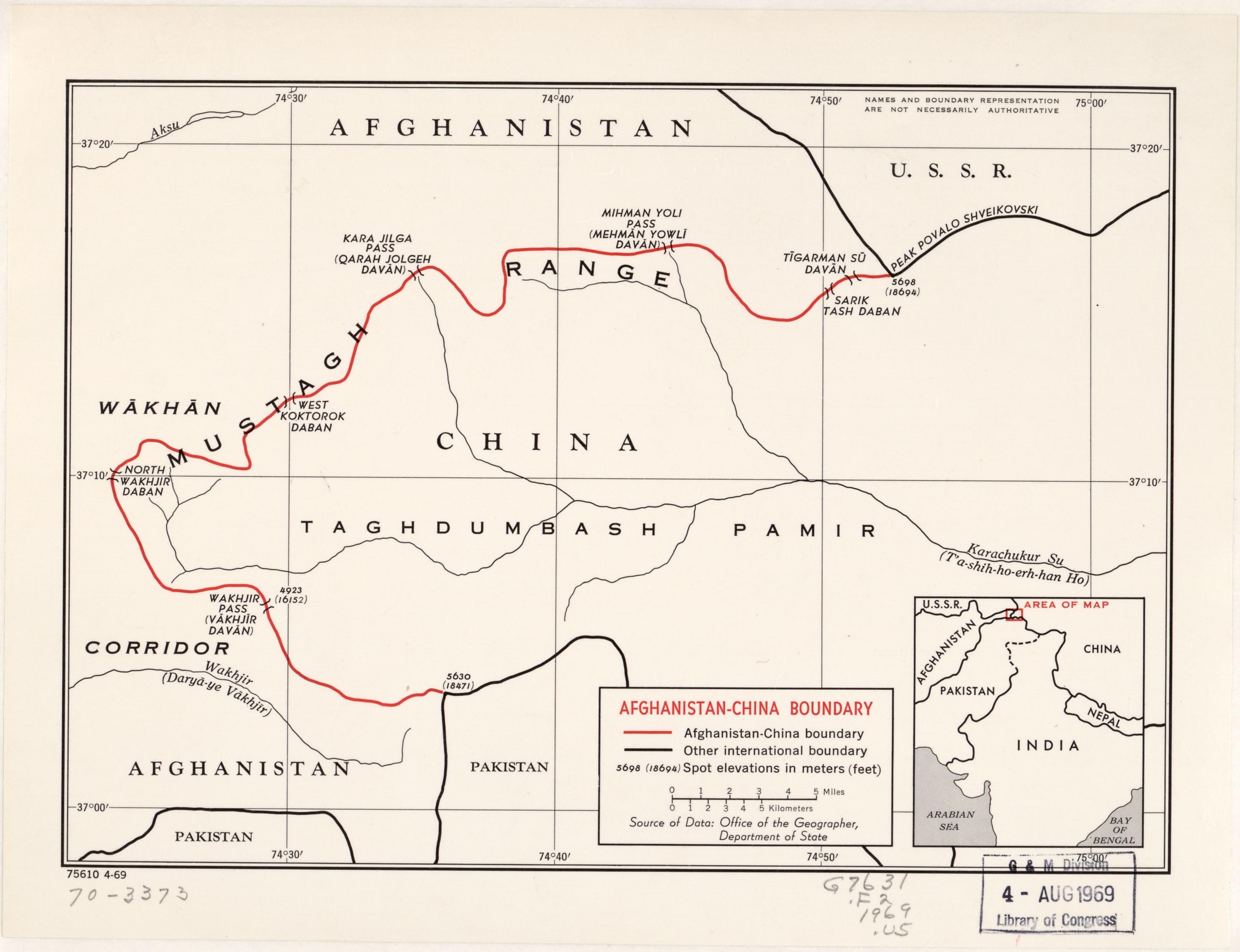
Wakhjir Pass
Cross the Wakhjir Pass and your watch jumps three and a half hours forward, the sharpest timezone shift of any land border on Earth. The pass sits where the Hindu Kush meets the Pamirs, at the fingertip of Afghanistan's Wakhan Corridor, a sliver of territory so narrow and remote that it exists less as a place people live than as a cartographic accident of 19th-century imperial bargaining. It is the only potentially navigable crossing between Afghanistan and China, and for most of the year it is not navigable at all.
A Corridor Between Empires
The Wakhan Corridor owes its strange, elongated shape to the Great Game, the decades-long rivalry between the British and Russian empires for influence in Central Asia. In 1895, the two powers drew a boundary that wedged a strip of Afghan territory between Russian-controlled Pamir and British India, creating a buffer zone neither side would control. The Wakhjir Pass, at the corridor's eastern terminus, became the official border between Afghanistan and China, though the Afghans and Chinese did not formally agree to it until 1963. The result is a geographic oddity: a pass connecting two countries that share only 76 kilometers of frontier, pinched between the territories of Tajikistan, Pakistan, and the disputed borderlands of Kashmir.
Footprints in the Ice
The list of outsiders who have successfully crossed the Wakhjir Pass can nearly be counted on two hands. Marco Polo is believed to have traversed it during his journey through the Pamirs in the 13th century, though he never named it. The Jesuit priest Benedict Goez made the crossing between 1602 and 1606, traveling from the Wakhan into China on a mission to determine whether Cathay and China were the same place. Then silence, for nearly three centuries, until the Great Game brought a succession of British surveyors and adventurers. In 1868, a pundit known as the Mirza crossed for the Great Trigonometric Survey of India. Captain T.E. Gordon followed in 1874, Francis Younghusband in 1891, Lord Curzon in 1894. When Aurel Stein crossed in May 1906, he reported that the approaches were "remarkably easy" but that the pass carried only about 100 pony loads of goods each way per year. The last known Western crossing belongs to the mountaineer H.W. Tilman in 1947.
The Locked Door
Today, barbed wire stretches across the border at the pass. On the Chinese side, the Chalachigu Valley is closed to all visitors; only military personnel, local residents, and herders are permitted access. A border guard outpost at Keketuluke watches over the approach. In 2009, China began building a road through the Taghdumbash Pamir toward the pass, connecting it to the Karakoram Highway. On the Afghan side, the nearest settlement is Sarhad-e Broghil, a village reachable only by paths. Just below the pass, an ice cave marks the source of the Wakhjir River, which feeds into the Amu Darya, the ancient Oxus. Afghanistan has repeatedly asked China to open the crossing for trade and as an alternative supply route, but Beijing has refused, citing security concerns related to unrest in Xinjiang. In July 2024, road construction on the Afghan side was reported to have finally reached the pass itself.
Ice Cave and Frozen Ground
The Wakhjir Pass sits in a tundra climate that borders on ice cap conditions. Even in July and August, the warmest months, temperatures barely nudge above freezing. Continuous permafrost grips the ground year-round, and the pass is traditionally inaccessible for at least five months, with only irregular windows of passage during the remaining seven. The terrain is described as extremely difficult, though Stein's observation about the approaches being "remarkably easy" suggests the final ascent is less daunting than the journey to reach it. That journey, from either direction, crosses some of the most isolated high-altitude terrain in Asia, through valleys where the nearest neighboring country is never far but the nearest city always is.
Between Two Worlds
The Wakhjir Pass embodies a paradox: it is a connection between civilizations that functions as a barrier. Silk Road merchants once used it to move goods between Badakhshan and Yarkand, carried by ponies and human endurance across the roof of the world. Now the same route reportedly carries low-intensity opium traffic from Afghanistan into China. The geopolitics have changed, but the fundamental character of the place has not. It remains a gap in the mountains where two vast countries almost touch, separated by altitude, weather, razor wire, and the accumulated distrust of nations. Stand at the pass and Afghanistan stretches west under UTC+04:30. Turn around and China begins, running on Beijing time, UTC+08:00, three and a half hours into the future. Few borders make the arbitrariness of political geography feel so visceral.
From the Air
Wakhjir Pass sits at approximately 37.09N, 74.48E, at the extreme eastern end of Afghanistan's Wakhan Corridor where the Hindu Kush meets the Pamirs. Elevation approximately 4,923 meters (16,152 feet). Fly at or above FL200 for safe terrain clearance. The pass is surrounded by peaks exceeding 6,000 meters. Nearest airports: Fayzabad (OAFZ) roughly 250 km west in Afghanistan, Kashgar (ZWSH) roughly 420 km northeast in China. Expect severe turbulence, icing conditions, and rapidly changing mountain weather. The narrow Wakhan Corridor is visually distinctive from altitude, a thin green valley pinched between snowcapped ranges.