Walls of Old San Juan
The garitas give it away. Those small stone sentry boxes perched along the ramparts have become the unofficial emblem of Puerto Rico -- printed on license plates, painted on souvenir mugs, tattooed on forearms. But the bartizans are decoration on something much larger. Three miles of masonry walls, begun in 1634 and completed by 1783, once encircled the entire San Juan Islet. About three-quarters of them still stand. Boston tore down its walls. Charleston dismantled its fortifications. New Orleans let the levees replace them. San Juan kept its ring of stone, making it the only walled city still standing under the flag of the United States.
A Circle Drawn in Stone
Construction began modestly -- earthworks and palisades thrown up to protect a harbor the Spanish Crown considered essential. San Juan Bay was the gateway to the Caribbean trade routes, and any ship entering or leaving had to pass under the islet's guns. By the mid-17th century, engineers were laying courses of sandstone and limestone, connecting the already formidable fortresses of El Morro on the northwest headland and San Cristobal on the eastern approach. The wall grew section by section over 150 years, incorporating bastions, batteries, powder magazines, and two main gates: the Puerta de San Juan on the harbor side, which sailors called Puerta de Agua -- the Water Gate -- and the Puerta de Tierra on the eastern landward end, officially the Gate of Santiago. By 1783 the circle was complete. San Cristobal, the largest colonial fortification built by Europeans in the New World, anchored the eastern flank. La Fortaleza, the governor's palace, nestled behind the western wall. Everything worth protecting sat inside.
What the Earthquake Took
On November 18, 1867, an earthquake struck the Virgin Islands and sent shocks rippling across Puerto Rico. The southeastern wall -- the stretch connecting San Cristobal to the southern harbor defenses -- cracked beyond repair. Decades earlier, the Spanish military had already shifted its eastern defense strategy to the Fortin de San Geronimo and an advanced defense line farther out on the islet. With the southeastern wall deemed militarily redundant and physically obstructive, officials made a decision that would reshape the city: they tore it down. The demolition opened Old San Juan to the east, allowing streetcar lines and railroad connections to link the walled city with the expanding mainland neighborhoods. Where the Gate of Santiago once controlled entry, Plaza Colon now stands. The district beyond the old gate still bears its name -- Puerta de Tierra, the Land Gate neighborhood -- a ghostly echo of the barrier that once defined where the city ended and the island began.
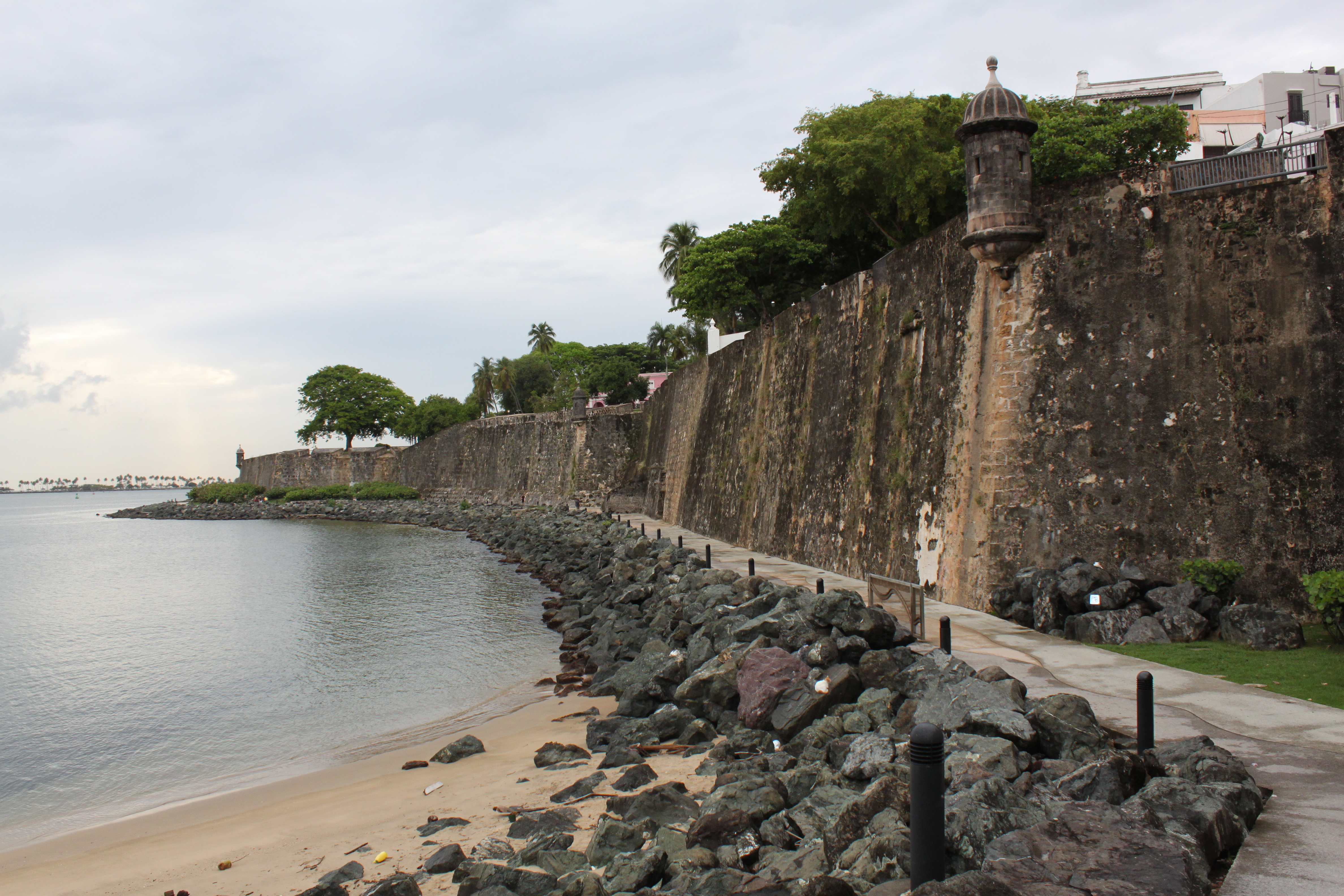
The Devil's Sentry Box and the Pearl Below
Walk the northern wall along Norzagaray Street and the Atlantic crashes against the rocks far below. This stretch runs from San Cristobal westward toward El Morro, studded with bastions named for saints: Santa Teresa, San Sebastian, Santo Tomas, Las Animas, San Antonio. One sentry box here earned the name Garita del Diablo -- the Devil's Sentry Box. Legend says a soldier stationed there vanished without a trace, and superstition blamed the devil himself. The more likely explanation involves desertion, the sea, or the kind of boredom that makes a man walk away from guard duty in the Caribbean night. Below this wall, between the ramparts and the ocean, the neighborhood of La Perla grew up organically beginning in the 17th century around slaughterhouse sites that the walled city preferred to keep outside its gates. La Perla still sits there, pressed between stone and surf, its colorful houses visible from the wall walk above -- a community that has existed in the shadow of the fortifications for as long as the fortifications themselves.
The Walls as Living City
The southern wall along Paseo de La Princesa tells a gentler story. Named for the military prison -- La Princesa -- that once stood along its length, the promenade now draws evening strollers past fountains and craft vendors. The Bastion de la Concepcion shelters the historic Convent of the Servants of Mary, who ministered to the sick. Farther along, the Parque de las Palomas opens through the wall itself, and the Capilla del Santo Cristo de la Salud perches on the rampart edge, one of the most photographed chapels in Puerto Rico. La Fortaleza, originally built as a military stronghold, has served as the governor's residence since the 16th century -- making it the oldest executive mansion in continuous use in the Americas. These walls are not museum pieces roped off behind velvet cords. People live against them, worship in chapels built into them, and walk along their tops at sunset. Together with El Morro and San Cristobal, they form the UNESCO World Heritage Site known as the San Juan National Historic Site -- a designation earned not because the walls are picturesque, though they are, but because they represent three centuries of military engineering adapted to Caribbean conditions.
From the Air
Located at 18.467N, 66.110W on the San Juan Islet, Old San Juan, Puerto Rico. The walls are clearly visible from the air as a continuous stone perimeter encircling the western portion of the islet. The northern wall faces the Atlantic, the southern wall faces San Juan Bay. Key landmarks: El Morro fortress at the northwest tip, San Cristobal fortress at the eastern approach, La Fortaleza (governor's palace) along the western wall. Nearest airports: Fernando Luis Ribas Dominicci (TJIG) approximately 1 nm south, Luis Munoz Marin International (TJSJ) approximately 8 nm east. Best viewed at 1,500-3,000 ft AGL to appreciate the wall circuit. The gap in the southeastern section -- where the walls were demolished after 1867 -- is visible as the point where the colonial street grid transitions to wider modern avenues.