Walnut Canyon National Monument
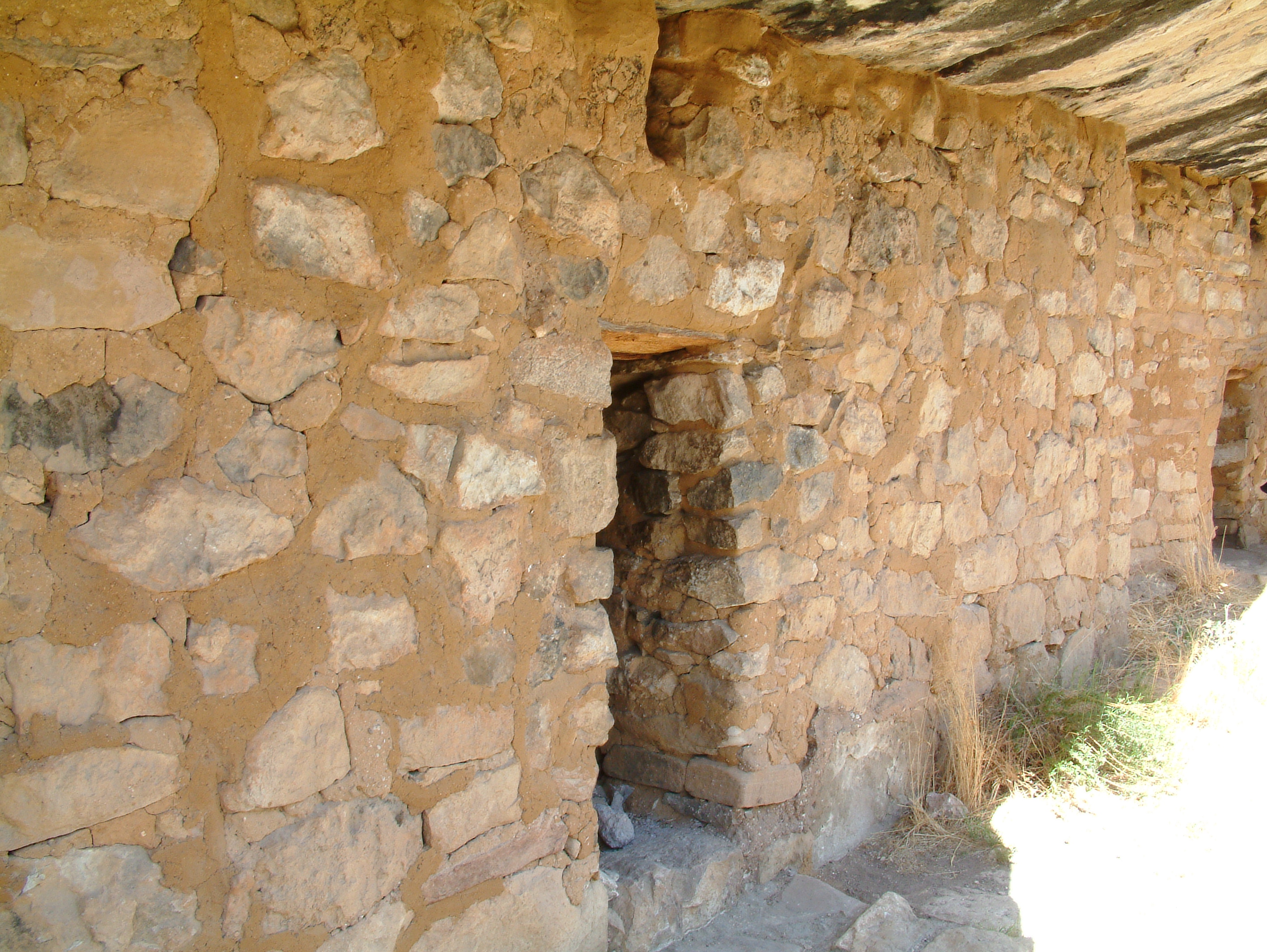
Their name is a contradiction. "Sinagua" is Spanish for "without water," yet these people managed to farm, trade, and build a civilization in one of Arizona's driest landscapes. Between 1125 and 1250 AD, the Sinagua carved out a life inside Walnut Canyon, constructing more than 80 cliff dwellings beneath limestone ledges that had been hollowed by millions of years of flowing water. The rooms were small - roughly two meters high, six meters long, three meters deep - but they were enough to cook and sleep in, tucked into the canyon walls where the rock itself became ceiling and insulation. Then, around 1250, the Sinagua vanished. The Hopi call the place Wupatupqa. The dwellings they left behind, silent beneath the limestone, would wait more than six centuries before anyone thought to protect them.
Living in the Ledges
Walnut Canyon is not a grand chasm. It is an intimate space - a sinuous cut through limestone where Walnut Creek carved its path eastward toward the Little Colorado River and eventually the Grand Canyon. The Sinagua chose their home sites with precision, building under natural recesses in the cliff walls where erosion had already done the heavy lifting. The limestone alcoves offered shelter from rain and snow, shade from the punishing summer sun, and a defensible position high above the canyon floor. A loop trail today descends into the canyon and passes 25 of these cliff dwelling rooms, most perched slightly above the path. A typical room housed a single family. The dwellings cluster around a dramatic U-shaped meander where the creek circles three sides of a high rocky plateau, creating something close to an island - a natural fortress the Sinagua exploited to its fullest. Despite the aridity, the Sinagua became expert water conservators, harvesting maize, beans, and squash from the dry land around them.
Three Layers of Stone
The canyon walls tell their own story in three distinct geological chapters. The upper third is Kaibab Limestone - the same formation that caps the rim of the Grand Canyon, 80 miles to the northwest. It varies in hardness and layering, and it is here, where softer beds eroded into alcoves, that the Sinagua built their homes. Below the limestone, steep slopes of the Toroweap Formation support scrubby vegetation. The lowest third drops into sheer walls of Coconino Sandstone, cross-bedded and ancient. The geology created more than just shelter. The canyon's orientation produces dramatically different ecosystems on opposite walls: the shaded, north-facing slopes are draped in Douglas fir and ponderosa pine, while the sun-baked southern exposures grow agaves, prickly pear, opuntia, echinocereus, and cholla. The canyon floor supports several species of walnut trees - the namesake of the canyon itself. More than 387 plant species have been documented within the monument, a biodiversity that likely attracted the Sinagua as much as the limestone shelters did.
Traders Without Water
The Sinagua were not isolated cliff-dwellers waiting out the centuries in quiet subsistence. Evidence suggests they were active traders whose networks reached the Gulf of Mexico and possibly Central America. Their skill at surviving without reliable water sources made them adaptable, and Walnut Canyon sat within reach of other Sinagua communities preserved today at Tuzigoot and Montezuma Castle national monuments. The people who inhabited these walls were connected to a wider world. Yet around 1250 AD, they left. Fear of neighboring tribes, prolonged drought, or some combination of pressures drove them out, and the canyon fell silent. What they left behind - over 80 cliff dwellings, tools, traces of agriculture - drew attention from explorers and looters in the mid-1800s. The damage was significant enough that on November 30, 1915, President Woodrow Wilson proclaimed Walnut Canyon a national monument to preserve what remained.
The Canyon Endures
The monument transferred from the USDA Forest Service to the National Park Service on August 10, 1933, and was listed on the National Register of Historic Places on October 15, 1966. Today, approximately 3,600 acres of archaeological and natural resources are preserved here. The climate has not softened: snow blankets the rim in winter, afternoon thunderstorms rake the canyon in summer, and spring winds howl along the exposed edges. The Island Trail loop descends into the canyon for close encounters with 25 cliff dwelling rooms. A separate Rim Trail offers views from above. Walnut Canyon sits just seven miles east of Interstate 40 and three miles south of exit 204 - startlingly close to the modern world for a place that feels so thoroughly ancient. The limestone still erodes, the creek still carves, and the alcoves still hold their shape, waiting as patiently as they did when the Sinagua first looked up at them and saw home.
From the Air
Walnut Canyon National Monument is located at 35.1658N, 111.5019W, approximately 7 miles southeast of downtown Flagstaff, Arizona, just south of Interstate 40. The canyon runs roughly east-west and is carved by Walnut Creek, a tributary of the Little Colorado River. Canyon rim elevation is approximately 6,690 feet MSL with the floor roughly 350 feet lower. The U-shaped meander at the monument's core is distinctive from the air. Nearest airport: Flagstaff Pulliam Airport (KFLG), approximately 8 nm to the west-southwest. I-40 passes just north of the monument and serves as a visual reference. The San Francisco Peaks (12,633 feet) are visible to the north-northwest. Expect variable weather conditions at this elevation - snow in winter, summer thunderstorms, and strong spring winds.