Warmbad, Namibia
In 1811, five years after missionaries built the first European-style buildings on South West African soil, the local Orlam community burned them both to the ground. The church and the pastor's house that Abraham and Christian Albrecht of the London Missionary Society had erected at this hot springs settlement were not simply structures -- they were symbols of European influence that Jager Afrikaner and his people rejected with fire. That act of resistance did not erase Warmbad from the map. It ensured that the settlement's history would begin with a confrontation rather than a founding myth.
Springs in a Thirsty Land
Warmbad sits in the southern reaches of Namibia's Karas Region, along the Homs River near the South African border. The name means exactly what it says: "warm bath" in both Afrikaans and German. The Nama name, |Aixa-aibes, predates both colonial languages. The hot springs that gave the settlement its identity attracted traders, hunters, and adventurers traveling from the Cape Colony long before any mission was established. Climatically, the area falls between the coastal desert and the Karoo -- frost in winter, negligible rainfall averaging just 96 millimeters per year, and mean temperatures between 12 and 15 degrees Celsius. In this landscape, a permanent source of warm water was not a curiosity. It was a destination.
Missionaries and Destruction
In 1805, Abraham and Christian Albrecht of the London Missionary Society arrived and began building. By 1806, they had established what is considered the first mission station in South West Africa -- the assumed foundation year of the settlement itself. Their church and pastor's house were the first European-style buildings in the territory. But the Orlam community, led by Jager Afrikaner, saw these structures as instruments of unwanted influence. In 1811, they destroyed both buildings. For years afterward, the oldest standing structure in Namibia was believed to be the Schmelenhaus in Bethanie, built in 1814 -- until the much older ruins of Khauxanas were rediscovered. In 1834, Wesleyan missionary Edward Cook arrived and built a new missionary house on the foundations of the ones the Orlam had destroyed. The British scientist Sir James Edward Alexander stayed in one of its rooms during an 1836 expedition. In the 1840s, missionary Benjamin Ridsdale was stationed here, calling the place Nisbett Bath. The Rhenish Missionary Society took over in 1867, building a school in 1868 and a new church in 1877.
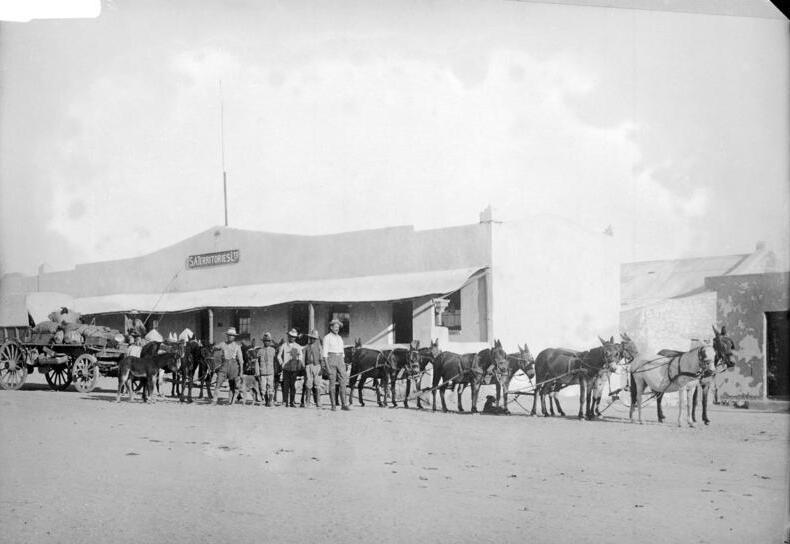
Fort, Springs, and Uranium
After Imperial Germany claimed South West Africa, a fort was built at Warmbad in 1905 and Schutztruppe soldiers were garrisoned to counter the Herero and Nama uprising that was convulsing the territory. The colonial period left its mark in military architecture and administrative control, but the hot springs remained the settlement's defining feature. Under the subsequent South African mandate, the springs were sold to a private investor for 12,000 Rand. After Namibian independence, the government bought them back for five times that amount, returning them to community ownership. In 2009, Canadian mining company Xemplar Energy announced the discovery of significant uranium deposits in the area, adding yet another chapter to the settlement's long history of being valued for what lies beneath its surface.
The Church by Donkey Cart
After the Second Boer War, some Afrikaners emigrated to German South West Africa rather than live under British rule, and Warmbad became part of the growing Afrikaans-speaking frontier. The Dutch Reformed Church pioneer Reverend Leonard ministered to settlers across the vast territory largely by ox and donkey cart -- a detail that captures the scale of the distances involved. On 23 June 1928, the Warmbad congregation split from the Dutch Reformed Church Keetmanshoop, which was itself an offshoot of the Gibeon congregation, the mother church of all Namibian NGK denominations. Dr. A.J. Stals became the first pastor in October 1929, serving through drought and the Great Depression until 1935. The church's story mirrors the settlement's own: a series of arrivals, departures, and reinventions in a place where permanence is always negotiated with the landscape.
From the Air
Located at 28.45S, 18.73E in southern Namibia, close to the South African border. The settlement sits along the Homs River south of Karasburg. From the air, Warmbad appears as a small cluster of buildings in otherwise arid, sparsely vegetated terrain. The road south leads to the South African border crossing. Nearest significant airport is Keetmanshoop (KMP) to the north. Karasburg, the larger town and electoral constituency center, is nearby to the north. Terrain is flat desert with scattered scrub; no significant altitude concerns. The hot springs area may be identifiable from lower altitudes by any development or greenery around the water source.