Warren County PCB Landfill
In the summer of 1982, residents of Warren County, North Carolina did something no Americans had done before: they lay down in the road to stop a landfill. Over six weeks, more than 550 people were arrested as they blocked 10,000 truckloads of PCB-contaminated soil from reaching a dump site near the small community of Afton, three miles south of Warrenton. The Washington Post called it "the marriage of environmentalism with civil rights." The EPA later described it as "the watershed event that led to the environmental equity movement of the 1980s." The phrase "environmental racism" entered the American vocabulary. And it all began with a modified tanker truck, a nozzle, and 210 miles of poisoned roadway.
The Midnight Dumpers
The crisis started in 1978 when Robert Ward of the Ward Transformer Company in Raleigh contracted Robert Burns and his two sons to dispose of large quantities of polychlorinated biphenyls -- PCBs -- which Congress had banned under the Toxic Substances Control Act of 1976. The legal disposal was expensive. So Ward and Burns improvised: they modified a 750-gallon tanker truck with a nozzle that could spray PCB-contaminated oil from the tank as the vehicle drove. In June 1978, two truckloads were sprayed on Fort Bragg land. When the sandy soil proved unsuitable, they moved to rural back roads. Through July and August, Burns and his sons dumped approximately 12,850 gallons of PCB-tainted fluid at 51 locations across 210 miles of roadway in 14 North Carolina counties. Authorities first noticed discolored grass and soil along 11 miles of Fort Bragg roadway. On July 31, Warren County officials spotted oil alongside North Carolina Highway 58.
Choosing Warren County
The state needed somewhere to put the contaminated soil it scraped from those 210 miles of road. Governor Jim Hunt's administration announced in December 1978 that "public sentiment would not deter the state from burying the PCBs in Warren County." The choice was immediately controversial. Warren County was rural, with about 18,000 residents. Sixty-nine percent of those residents were non-white. Twenty percent lived below the federal poverty level. The county was classified Tier I for economic development -- the state's designation for its most distressed areas. Critics charged that the site selection was not based on scientific criteria like soil permeability or distance to groundwater, but on the demographics of a community with little political power. The EPA and state officials insisted that the landfill's engineering would compensate for the site's shortcomings, calling it a "state-of-the-art, dry-tomb, zero-percent discharge" facility.
Bodies in the Road
When the trucks began rolling in 1982, Warren County's residents mounted what the Duke Chronicle described as "the largest civil disobedience in the South since Dr. Martin Luther King Jr. marched through Alabama." For six weeks, citizens used collective nonviolent direct action to oppose the dumping. More than 550 people were arrested -- the first time in American history that citizens were jailed for trying to stop a landfill. The protesters lost the immediate fight: the contaminated soil went into the ground. But the arrests, the images, and the moral clarity of the protest reverberated nationally. The Warren County action inspired the United Church of Christ's Commission for Racial Justice to produce "Toxic Waste and Race," the first national study correlating the locations of waste facilities with demographic characteristics. The study found that race was the most significant variable in predicting where hazardous waste sites were located -- more powerful than poverty, land values, or homeownership.
A Landfill That Leaked
The "zero-percent discharge" landfill did not stay dry. By 1996, data showed that 30,000 gallons of water flowed into the site each year and 26,000 gallons flowed out. In May 1993, more than a decade after the governor had promised to detoxify the landfill when technology allowed, citizens learned of an emergency: nearly a million gallons of water inside the landfill threatened to breach the liner. Community advocate Ken Ferruccio negotiated a five-point framework with Governor Hunt's administration, demanding ongoing monitoring, citizen representation, and permanent detoxification as the ultimate goal. Hunt agreed. In 1999, the General Assembly committed roughly eight million dollars to cleanup, with the EPA matching the funds. Earth Tech was hired for oversight, and the IT Corporation won the decontamination contract at $13.5 million.
Slow Justice
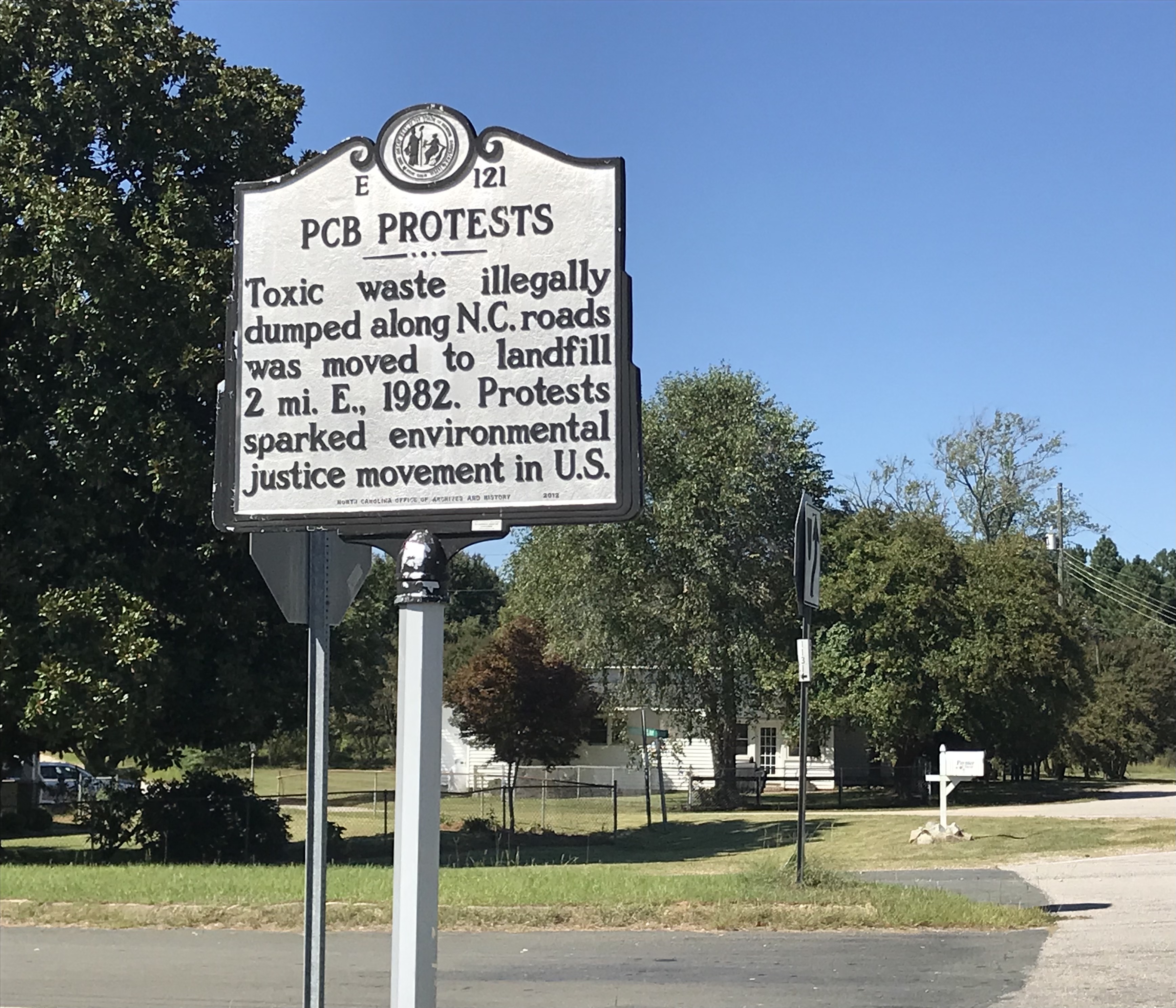
Soil treatment began in earnest after EPA testing in January 2003. By October of that year, 81,600 tons of contaminated soil had been treated using Base Catalyzed Decomposition. Equipment was removed by the end of 2003, and the detoxification was formally completed in 2004 -- more than two decades after the original dumping. The final cost exceeded $25 million, much of it consumed by studies and administrative overhead rather than the actual cleanup. Today, a highway marker in Afton commemorates the landfill protests. The site itself is unremarkable from the air -- just a patch of cleared land in the gentle rolling countryside of Warren County. But what happened here changed American law, policy, and conscience. The environmental justice movement that Warren County citizens birthed has shaped regulation, litigation, and community organizing across the country ever since.
From the Air
Located at 36.35°N, 78.16°W near Afton, approximately 3 miles south of Warrenton, North Carolina. The site is in the rural rolling Piedmont of Warren County. Nearest airports include Henderson-Oxford Airport (KHNZ) approximately 20 nm to the northwest and Rocky Mount-Wilson Regional Airport (KRWI) approximately 30 nm to the southeast. The landscape is gently rolling farmland and forest. At 2,000-3,000 feet AGL, look for the cleared area along NC Highway 58 south of Warrenton.