Waru Waru
The potato should not grow here. At 3,800 meters on the Andean altiplano, night temperatures plunge below freezing, nitrogen-rich soil is scarce, and unpredictable floods can drown a season's work in hours. Yet around Lake Titicaca, pre-Hispanic farmers solved all three problems with a single elegant system: parallel raised planting beds separated by water-filled canals. They called it Waru Waru. The technique dates to around 300 B.C., and the fields it created once covered some 82,000 hectares of land across Bolivia and Peru -- an agricultural infrastructure so vast it sustained entire civilizations.
Engineering Against the Cold
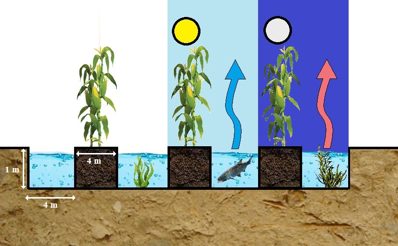
The genius of Waru Waru lies in how it turns water into an ally. Farmers mounded nutrient-rich mud from canal bottoms -- thick with decaying aquatic plants and organic material -- onto raised planting beds roughly a meter tall. During the day, the shallow water in the surrounding canals absorbed solar radiation and stored it as heat. At night, when temperatures on the open altiplano dropped below freezing, that stored warmth radiated upward, keeping the soil on the raised beds about one degree Celsius warmer than surrounding flat ground. Cold air, being heavier, drained off the mounded beds and pooled harmlessly in the canals below. It was not dramatic warmth, but for a potato crop at 3,810 meters, one degree meant the difference between a harvest and a loss. The canals also served as irrigation during dry spells and as drainage during the violent floods common to the tropical Andes, extending the growing season well beyond what rain-fed fields could support.
The Tiwanaku Legacy
Waru Waru is most closely associated with the Tiwanaku culture, which dominated the Lake Titicaca basin for centuries and used the raised fields to grow potatoes, quinoa, and other highland crops. The system did more than feed people. Flooded canals attracted fish and waterbirds, creating artificial ecosystems that provided additional protein sources for surrounding communities. Radiocarbon dating of habitation sites near the fields suggests continuous use from around 1000 B.C. to 400 A.D., with associated settlements large enough to indicate that raised-field agriculture sustained dense, long-term populations. Then, at some point before the Spanish arrived, the practice disappeared. Sixteenth-century Spanish chronicles described Andean agriculture in careful detail but never mentioned raised fields. By the time the conquistadors reached Lake Titicaca, the Waru Waru had already been abandoned, their earthen ridges slowly flattening back into the landscape.
Rediscovery in Unexpected Places
In the 1960s, geographers William Denevan, George Plafker, and Kenneth Lee found unmistakable traces of raised-field agriculture in Bolivia's Llanos de Moxos, deep in the Amazon basin -- a region long assumed incapable of supporting large-scale farming. The discovery upended assumptions about pre-Columbian land use and sparked a joint archaeological experiment. Beginning in 1990, archaeologist Clark Erickson partnered with the Inter-American Foundation, the Bolivian Institute of Archaeology, and local indigenous communities to rebuild functioning Waru Waru in the Beni Department. The restored fields successfully produced manioc and maize, required minimal upkeep after the first season, and generated their own self-sustaining ecosystems. Separately, in 1984, University of Chicago researcher Alan Kolata revived the technique near Tiwanaku and in Puno, Peru, demonstrating that the ancient system could still outperform modern rain-fed agriculture on the altiplano without any mechanized equipment.
Ancient Answers to Modern Questions
The revival of Waru Waru is not just an archaeological curiosity. Aymara- and Quechua-speaking communities around Lake Titicaca have adopted the technique as a practical farming method, using the harsh landscape that modern agriculture largely ignores. The raised beds provide natural fertilizer from canal sediments, frost protection from stored solar heat, and flood control from the drainage channels -- all without chemical inputs, heavy machinery, or deforestation. In the Amazon basin, the method offers an alternative to slash-and-burn clearing, allowing large-scale crop production on floodplains without destroying forest. The parallels to Mexico's chinampas, the famous floating gardens of the Aztecs, hint at a widespread pre-Columbian understanding of wetland agriculture that European colonizers never recognized. Across the altiplano today, the low earthen ridges of ancient Waru Waru still stripe the landscape, visible from the air as faint corrugations in the grass -- a pattern that quietly preceded modern sustainable agriculture by two thousand years.
From the Air
Located at 15.78S, 70.03W on the altiplano near Lake Titicaca at approximately 3,800 meters elevation. The ancient raised field patterns are visible from the air as subtle parallel ridges and canal depressions across the flat terrain surrounding the lake's western shores. Nearest airport is Inca Manco Capac International Airport (SPJL) in Juliaca, approximately 40 km north-northwest. The fields are distributed across a wide area of the Peruvian and Bolivian altiplano, with the most concentrated remains near Puno and Tiwanaku.