
Wash Woods, Virginia
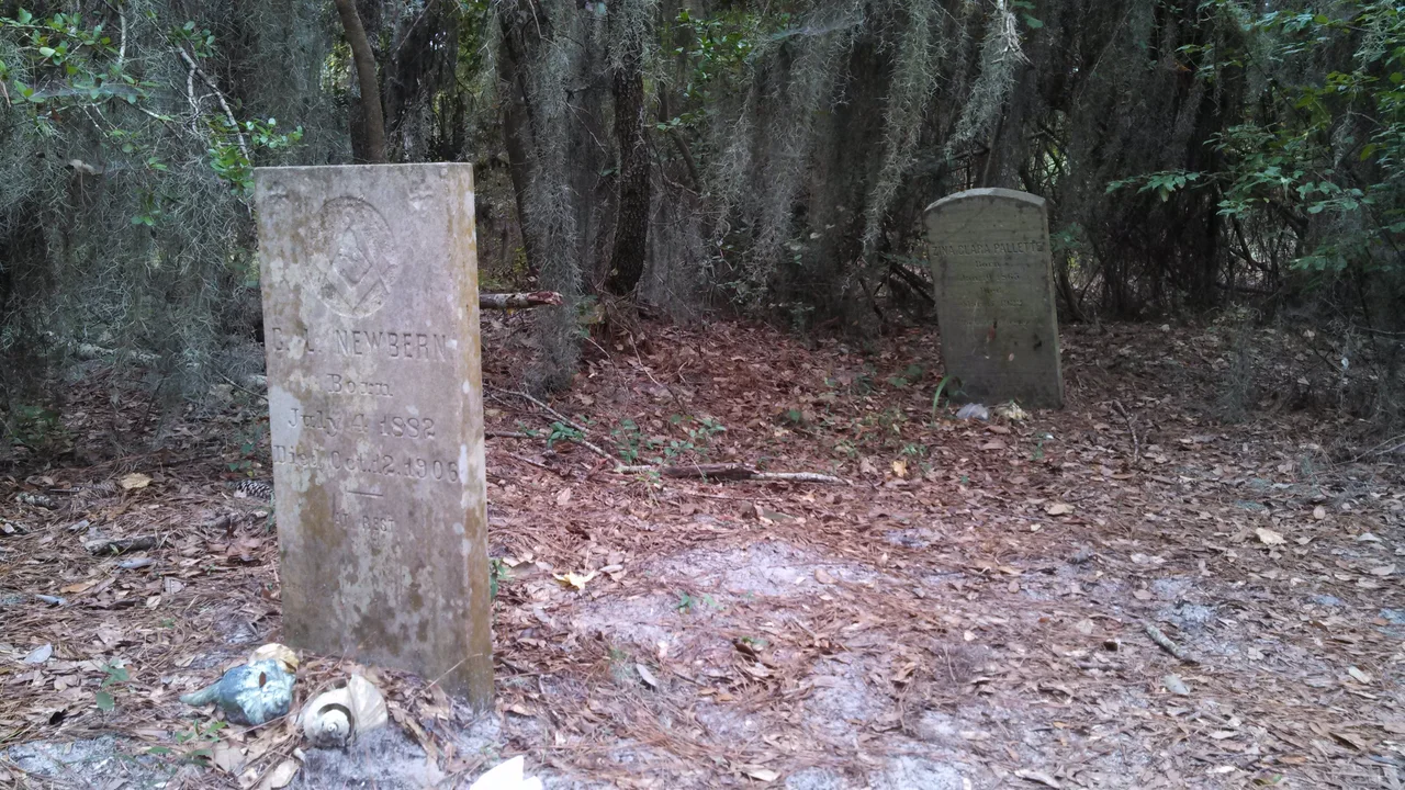
Wash Woods began the same way it ended: with the sea. Sometime in the 17th or 18th century, the survivors of a shipwreck on the long Virginia barrier coast waded ashore on a remote stretch of beach south of what would become Virginia Beach. There was no road in. No road out. They built houses from what the next storms washed up. They fished, farmed thin soil, hunted waterfowl in the Back Bay marshes, and patrolled the beach at night looking for other ships in trouble. By 1900, three hundred people lived in Wash Woods. By 1933, two hurricanes had decided that the people were not allowed to stay. By the 1950s, only the lifesaving station was still operating. Today there is a cemetery, a foundation where the Methodist church once stood, and a converted hunt clubhouse that the state park uses for an education center. The rest of the town is gone the way the town began - washed away.
The Cypress That Built the Town
In 1889, a schooner called the John S. Wood ran aground off this stretch of beach with a load of lumber and broke apart in the storm. The cypress wood that washed ashore from the wreck went into the village's Methodist church and several other structures. It was practical - cypress resists rot, and there was no other source of building material that did not have to be hauled in by boat. It was also the kind of poetic accident that defined Wash Woods: a town built from the wreckage of ships, by people whose ancestors had come ashore from wrecks themselves. The Methodist church's steeple stood until vandals knocked it down around 1980. The cypress trunks still mark the cemetery.
Two Lifesaving Stations
The town's economy was the coastal economy: fishing, farming, market hunting (selling waterfowl by the barrel to northern restaurants), and lifesaving. The False Cape Life-Saving Station was one of the first, established in 1875. After the disastrous wrecks of the Huron at Nags Head in November 1877 and the steamship Metropolis near the Currituck Beach Lighthouse in January 1878 - both producing massive loss of life and public outcry - Congress added Deal's Island Station south of Wash Woods in 1878. It was renamed the Wash Woods Station around 1883. In 1917 the original building was replaced by a more modern U.S. Coast Guard station. The men of the lifesaving service walked the beach at night, in any weather, watching for ships in distress. When they spotted one, they launched an open boat into the surf and rowed out to bring crews back through the breakers. It was dangerous, often fatal work. The 1917 Coast Guard station still stands a few miles south, across the state line at Carova Beach, restored in 1989 and now used as a real estate office.
The Storms That Ended Everything
The sea inundated the narrow sandy strip so often that residents had begun to leave by the 1920s. The Migratory Bird Treaty Act of 1918 outlawed market hunting and took another economic leg out from under the town. Then came August 1933. The 1933 Chesapeake-Potomac Hurricane hit first - a Category 4 storm with a massive storm surge. The 1933 Outer Banks hurricane followed soon after, equally severe. Together the storms flooded the entire peninsula, damaged the Coast Guard Station, and washed the fertile topsoil from the farm fields into Back Bay. For the families still trying to hold on, the message was clear. They loaded what they could into boats and rowed across Back Bay to Knotts Island or to mainland Princess Anne County. The town did not really die in 1933. It just admitted that it had been losing for a long time.
The Hunt Clubs and the Park
After the residents left, the land became home to several waterfowl hunting clubs - wealthy sportsmen who could afford to maintain remote lodges and who valued the abundant ducks and geese of Back Bay. The clubs ran the area for about thirty-five years. In 1968 the Commonwealth of Virginia took over the land and incorporated it into what became False Cape State Park. The Wash Woods Environmental Education Center is housed in a converted hunt clubhouse. The bird life that supported the market hunters now supports birdwatchers - the area sits along a major Atlantic flyway, and migrating waterfowl pass through by the hundreds of thousands.
Thirteen Voters
One last footnote belongs to Wash Woods, and it is strange enough to be worth telling. Into the mid-1950s, Wash Woods remained a registered voting precinct - with exactly thirteen registered voters. Under Virginia law at the time, when all the voters in a precinct had voted in person, the precinct could close and report results. Senator Harry F. Byrd Sr.'s political machine, the Byrd Organization, controlled state Democratic politics with an iron grip. The Wash Woods thirteen would gather just after midnight on election day, vote the straight Democratic ticket, and report results within minutes - giving the Byrd machine an early-morning psychological boost that the press would carry into national coverage. In the mid-1960s, two voters opposed to the Byrd Organization arranged to register at Wash Woods and submitted absentee ballots by mail. Under Virginia law, that meant the precinct could not close immediately - and the entire arrangement collapsed. Local officials dissolved the precinct after the next election. The last political fact about Wash Woods, after everything else was gone, was that two people had voted by mail and broken the system.
From the Air
The Wash Woods site lies at 36.58°N, 75.87°W inside False Cape State Park, on the Atlantic side of the Currituck Banks Peninsula about a mile north of the North Carolina border. From cruising altitude, look for the Wash Woods cemetery clearing in the maritime forest just inland from the dune line, with Back Bay opening to the west. Norfolk International Airport (KORF) lies about 26 nm northwest; First Flight Airport (KFFA) at Kitty Hawk is about 29 nm south. The 1917 Wash Woods Coast Guard Station building still stands just south of the state line at Carova Beach. Best viewing at 2,500-4,000 feet.
Nearby Stories
- Naval Station Norfolk Chambers Field 4.1 km away
- Dismal Swamp Canal 13 km away
- Battle of the Chesapeake 21 km away
- Harvey Point Defense Testing Activity 32 km away
- Battle of Elizabeth City 36 km away
- SMS Ostfriesland 65 km away
- Steamship Pulaski Disaster 85 km away
- SS Monroe (1902) 107 km away