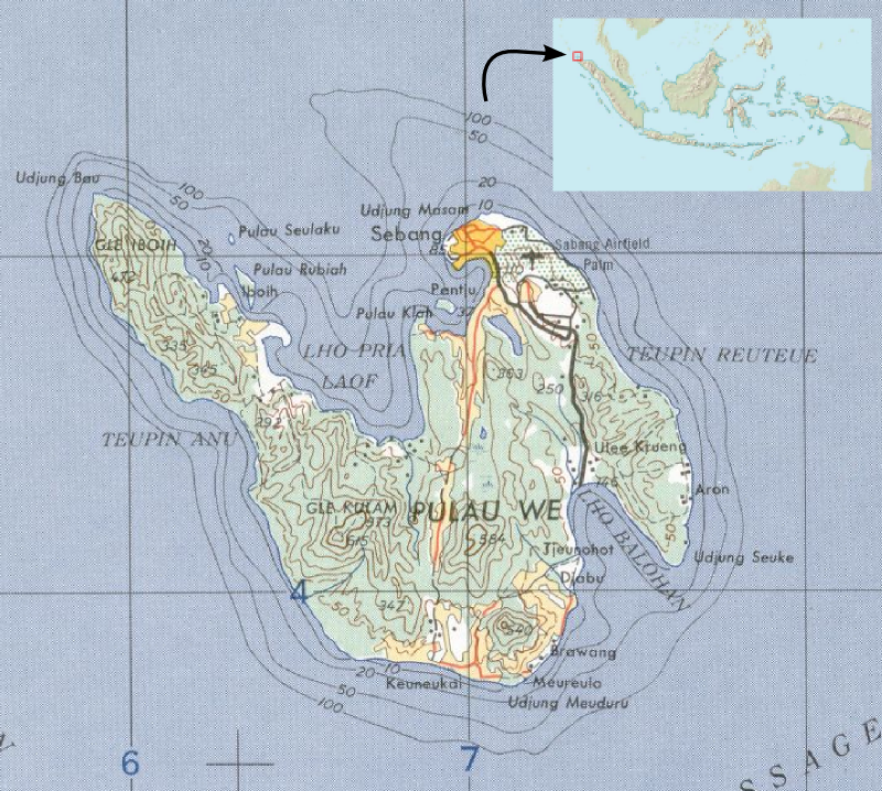
Weh Island
Bubbles rise from the seafloor off Gapang Beach, not from any diver's regulator but from the earth itself. Underwater fumaroles vent volcanic gases through the sand here, warming the surrounding water and drawing curious divers to a site simply called Hydrothermal Point. This is Weh Island, a 121-square-kilometer volcanic remnant sitting 15 kilometers off the northernmost tip of Sumatra, where the Indian Ocean meets the Andaman Sea. Once physically connected to the mainland, Weh broke free during a Pleistocene eruption and has been going its own way ever since.
The Volcano That Became an Island
Weh's backbone is Cot Kulam, a fumarolic stratovolcano rising 617 meters above the sea. The peak still vents steam and sulfurous gases, a reminder that the geological forces that tore the island from Sumatra have not gone quiet. The terrain drops steeply from that volcanic spine to a coastline that alternates between black sand and white, depending on which side of the island you stand on. Anoi Itam Beach takes its name from the dark volcanic sand that lines its shore, while Iboih and Gapang offer the bright white sand that postcards favor. The island is mountainous enough that hiking trails wind through dense tropical forest on the upper slopes, and the volcanic soil supports clove and coconut plantations that have anchored the local economy for generations.
Where Empires Passed Through
Weh Island sits beside one of the world's busiest shipping lanes. Fifty thousand vessels transit the Strait of Malacca each year, and for centuries this position has shaped the island's fortunes. The population of roughly 43,500 is predominantly Acehnese, with Minangkabau, Javanese, Batak, and Chinese communities adding linguistic and cultural layers. As part of Aceh province, the island operates under Sharia law, though small Christian and Buddhist communities persist among the Javanese, Batak, and Chinese residents. In 2000, the Indonesian government designated the port city of Sabang a Free Trade Zone and Free Port, investing in deep-water harbor facilities, warehousing, and refueling infrastructure to capture logistics business from the international shipping traffic flowing past its doorstep.
The Wave and What Came After
On December 26, 2004, a magnitude 9.1 earthquake beneath the Andaman Sea triggered tsunamis that killed at least 130,000 people in Indonesia. Weh Island, though close to the epicenter, escaped the worst devastation that flattened nearby Banda Aceh on the mainland. But the wave still left its mark. At Iboih village, the tsunami destroyed a large swath of mangrove forest and deposited land debris across the coral reefs that sustain the island's diving economy. The ecological recovery effort began almost immediately. By 2005, approximately 14,400 mangrove seedlings had been replanted in an effort to restore the coastal buffer that protects both the shoreline and the reef ecosystem behind it.
A Toad's Last Stand
Weh Island is the sole habitat of Duttaphrynus valhallae, a toad species known only from a single specimen collected on the island. No other population has been found anywhere else in the world. Heavy deforestation across Weh has placed the species' survival in serious doubt, and scientists are uncertain whether any living individuals remain. The toad is not the island's only ecological distinction. Conservation International surveyed the surrounding coral reefs between 1997 and 1999, and the waters off Weh have yielded one of only a few dozen confirmed sightings of the megamouth shark, a deep-water species so rare it was not discovered until 1976. The specimen found near Weh measured 1.7 meters and was sent to the Indonesian Institute of Sciences for study.
Island Time, Underwater
Weh draws visitors who come for the water more than the land. Iboih Beach, barely 150 meters of white sand, is the island's busiest stretch of coast. Just offshore sits Rubiah Islet, ringed by coral reefs that make it a magnet for snorkelers and divers. Gapang Beach, a 45-minute drive from the port at Balohan, caters to backpackers with modest guesthouses, small restaurants, and several dive operators. There is no public transport on Weh, so getting around means hiring a driver or renting a vehicle. The island connects to the mainland through fast boats and ferries departing from Banda Aceh, a 45-minute or two-hour journey depending on the vessel. Maimun Saleh Airport in Sabang offers light aircraft flights to Sultan Iskandarmuda Airport in Banda Aceh for those who prefer to skip the crossing.
From the Air
Weh Island sits at approximately 5.83N, 95.31E, about 15 km northwest of Sumatra's northern tip. The volcanic peak of Cot Kulam reaches 617 m (2,024 ft), so maintain altitude above 3,000 ft when overflying. Maimun Saleh Airport (WITN) serves the island with a short runway suitable for light aircraft. Sultan Iskandarmuda Airport (WITT) in Banda Aceh is the nearest major field, approximately 30 nm southeast. The island is easily identifiable from the air by its mountainous profile rising from the sea, distinct from the flat coastal plains of mainland Aceh.