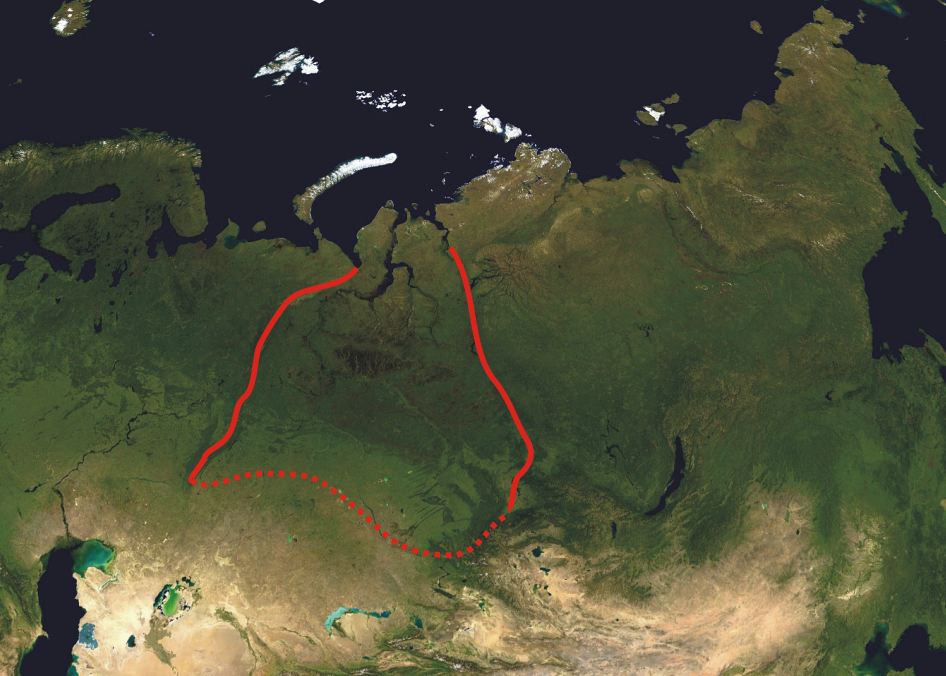
West Siberian Plain
A fifty-meter rise in sea level would drown everything between the Arctic Ocean and the confluence of the Ob and Irtysh rivers near Khanty-Mansiysk. That fact tells you almost everything you need to know about the West Siberian Plain. Covering roughly 2.7 million square kilometers, about one-third of all Siberia, this is flatness on a scale that defies intuition. From the Ural Mountains in the west to the Yenisei River in the east, from the Arctic Ocean in the north to the Altai Mountains in the southeast, the land barely rises, barely falls, and barely drains. It is one of the largest swamp systems on Earth, and beneath it sits one of the largest petroleum basins.
Flat Beyond Comprehension
The West Siberian Plain extends 2,500 kilometers from north to south and reaches a maximum width of 1,500 kilometers in the south. Five major rivers cross it from west to east: the Irtysh, Ob, Nadym, Pur, and Taz. The Yenisei, which forms the eastern boundary, discharges nearly 20 million liters of water per second at its Arctic mouth. Glacial deposits reach as far south as the Ob-Irtysh confluence, forming occasional low hills and ridges including the Ob Plateau, but otherwise the terrain is extraordinarily featureless. The Siberian Uvaly, a low hilly ridge, stretches east to west across the plain's midsection, providing one of the few topographic breaks. In the south, the Ishim Plain and Baraba Lowland support agriculture, while the Kulunda Plain extends into Kazakhstan, dotted with salt lakes and bordered by the Kokshetau Hills.
The Great Swamp
Poor drainage defines the plain. Soils are mostly peaty Histosols, and in the treeless north, Histels, permanently frozen organic soils. The region contains some of the world's largest peatlands, characterized by raised bogs that hold water like enormous sponges. The Vasyugan Swamp, covering approximately 53,000 square kilometers of the Vasyugan Plain, ranks among the world's largest single raised bogs. Vast interfluve swamps occupy the Ob-Taz floodplain, and large sections of the plain flood every spring when snowmelt overwhelms the nearly nonexistent gradient. From the air, the landscape in summer appears as an endless mosaic of water and green, lakes so numerous they resist counting, rivers that meander without constraint across ground that offers no resistance to their wandering.
Eight Worlds Stacked North to South
The plain contains eight distinct vegetation zones arranged in latitudinal bands: tundra, forest-tundra, northern taiga, middle taiga, southern taiga, sub-taiga forest, forest-steppe, and steppe. Animal species count rises from at least 107 in the tundra to 278 or more in the forest-steppe. In the south, where permafrost is largely absent, rich grasslands once extended the Kazakh Steppe northward, but nearly all of this original vegetation had been cleared for agriculture by the early twenty-first century. The northern taiga and tundra zones remain largely intact, though warming temperatures are shifting the boundaries of permafrost and changing the distribution of species that depend on frozen ground. Each zone has its own character: the open tundra scoured by Arctic wind, the dense larch and spruce of the taiga, the birch groves of the forest-steppe transitioning to open grassland.
Sixty-Five Million Years of Sinking
Geologically, the West Siberian Plain is a region of prolonged crustal subsidence. The bedrock consists of horizontal deposits laid down over 65 million years of the Cenozoic era, buried under alluvial sediments that accumulated as the crust slowly sank. During ice ages, massive ice dams blocked the northward-flowing Ob and Yenisei rivers, reversing their drainage southward into the Caspian Sea and possibly the Aral Sea. These episodes created the West Siberian Glacial Lake, whose remnants include the swamps and lake systems that dominate the modern landscape. The subsidence also created the conditions for the West Siberian petroleum basin, one of the world's richest hydrocarbon reserves. Most of Russia's oil and gas production during the 1970s and 1980s was extracted from this area, and the region's importance to the Russian economy has only grown since.
The Engine Room of Russia
Beneath the swamps and permafrost lies the resource base that powers modern Russia. The West Siberian petroleum basin holds vast reserves of oil and natural gas, with major cities like Surgut and Nizhnevartovsk existing solely because of extraction. Chelyabinsk, Novosibirsk, Omsk, and Tomsk anchor the southern margins of the plain, where industry and agriculture share the drier steppe and forest-steppe zones. The climate across most of the plain is either subarctic or continental, with harsh, long winters that define infrastructure decisions, construction techniques, and human endurance. Rivers serve as transportation corridors in summer and frozen highways in winter. The plain's sheer scale means that weather systems travel unimpeded for hundreds of kilometers, and storms arrive with little warning across terrain that provides no shelter.
From the Air
Centered approximately at 62°N, 76°E, the West Siberian Plain stretches from the Ural Mountains to the Yenisei River, 2,500 km north to south. From cruising altitude, the terrain appears as an immense flat expanse of tundra, taiga, and wetlands with countless lakes and meandering rivers. Major airports include Novosibirsk Tolmachevo (UNNT), Omsk Tsentralny (UNOO), Surgut (USRR), and Novy Urengoy (USMU). The Ob and Irtysh river systems are the dominant visual features. Expect continental and subarctic weather patterns. Recommended viewing altitude: 30,000+ feet to appreciate the scale.