Wildebeest Kuil Rock Art Centre
In 1875, a geologist and amateur ethnographer named George William Stow sent a package of drawings from the Diamond Fields to Dr. Wilhelm Bleek in Cape Town. The drawings were copies of rock engravings he had found on a low andesite hill between Kimberley and Barkly West, a place called Wildebeest Kuil. Bleek, one of the few Europeans of his era who took San culture seriously, responded that their publication "cannot but effect a radical change in the ideas generally entertained with regard to Bushmen and their mental condition." The engravings were not published. Instead, some of the original rocks were prised from the hillside and shipped to London for the Colonial and Indian Exhibition of 1886. At least two remain in the British Museum today. It took more than a century, but the land on which the remaining engravings sit is now owned by the !Xun and Khwe San communities, people whose broad cultural inheritance connects them to the artists who once pecked elephants, rhinos, and eland into the dark surface of these stones.
Stone Canvas of the Interior Plains
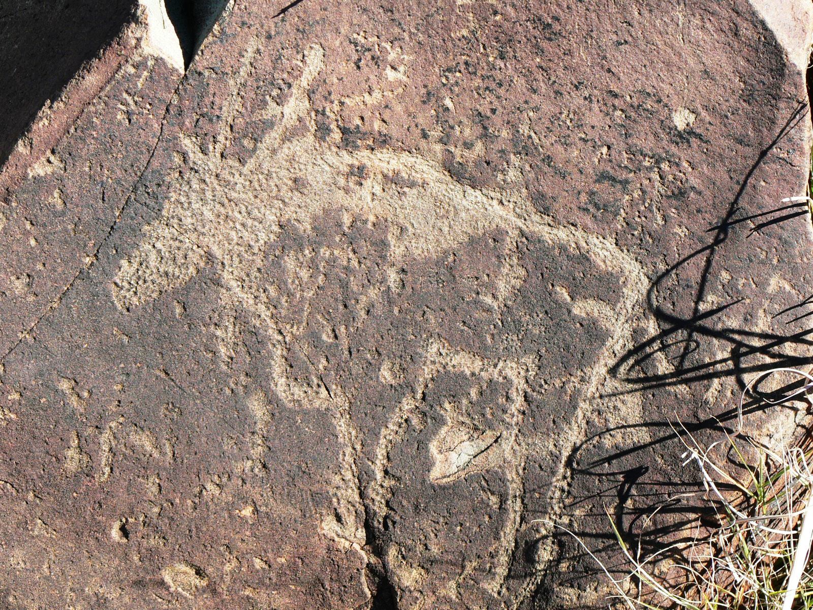
South Africa's rock art divides broadly along landscape lines. In the mountains, the Drakensberg, the Cederberg, and other ranges, the art takes the form of paintings in protected overhangs. On the interior plains, between the Vaal and Orange Rivers, the tradition is engraving. Different in technique, the two forms share deep thematic connections. But the engravings stand apart in their subject matter: large mammals like elephants, rhinoceroses, and hippos dominate the imagery, alongside the eland that is central to San spiritual life. The human figure, so prominent in Drakensberg paintings, appears less frequently here. At Wildebeest Kuil, the engravings were made by pecking. A hard stone was struck repeatedly against the dark outer crust of the andesite, chipping it away to expose lighter rock beneath. Over centuries, the exposed surfaces darkened again as mineral patina rebuilt, until the oldest engravings became nearly invisible against the weathered stone. When Gerhard and Dora Fock documented the site in 1968, they counted 178 individual engravings. Subsequent detailed plotting has revealed hundreds more.
Visions Pecked in Stone
Interpreting the engravings requires entering a worldview radically different from the one that colonial observers brought to the Diamond Fields. In the shamanistic framework that researchers have applied to much southern African rock art, the images relate to beliefs about rain and rain-making. Medicine people, or shamans, entered altered states of consciousness to access the spirit world, harnessing supernatural power to heal the sick, control the movements of game animals, and summon rain. The engravings may depict visions experienced during these trances, pecked into rock so that others could share in what the shaman had seen. The choice of location was itself significant. Not every rock outcrop attracted engravers. Certain hills and ridges appear to have been selected for their spiritual resonance, places where the boundary between the physical and spirit worlds was believed to be thin. Later Stone Age occupants of the site, living here between roughly 1,200 and 1,800 years ago based on radiocarbon dates, left stone circles, clearings, and tool assemblages on and around the hill. A Wilton assemblage overlain by Ceramic Later Stone Age material suggests the site saw sustained use across multiple cultural phases.
Kousop's Last Stand
The human history of Wildebeest Kuil extends well beyond the anonymous engravers. In 1909, a missionary named Westphal told Louis Peringuey that the last Khoe-San occupants of the site had been "Scheelkoos and his family." This is a rare surviving reference to a named Khoe-San individual from the frontier era. Scheelkoos, also known as Kousop, was not simply a resident. He led armed resistance to colonial settlement in the region, defending the land between the Vaal and Orange Rivers against encroachment. In 1858, colonial forces launched a counter-attack on the banks of the nearby Vaal River. Kousop was killed along with 130 of his followers. The violence of that moment sits uncomfortably beside the tourist trail that now winds past the engravings. But it is part of the same story: a landscape claimed, contested, lost, and partially reclaimed. The engravings survived Kousop. They survived the diamond rush. Whether they survived because people valued them or simply because they were too heavy to steal is a question the site's history answers both ways.
Homecoming Through Displacement
The current ownership of Wildebeest Kuil is the product of a history so layered it reads like a novel. The !Xun and Khwe are two San groups who speak distinct languages and carry different histories. Both were drawn into political turmoil in Angola during the 1960s and 1970s, then caught up in the border conflicts of Namibia. In 1990, when Namibia gained independence, roughly 4,000 !Xun and Khwe, men who had been employed by the South African Defence Force along with their families, were flown to a tent town at Schmidtsdrift, west of Kimberley. When that land was awarded to its former Tswana owners in a land restitution claim, the !Xun and Khwe had to move again. The purchase of Wildebeest Kuil and adjoining farms gave them a foothold, and resettlement to permanent housing at Platfontein on Kimberley's outskirts took place between 2003 and 2005. The rock art centre, opened in December 2001 and managed by the Northern Cape Rock Art Trust in partnership with the McGregor Museum, employs community custodians who guide visitors through the engravings. Declared a Provincial Heritage Site on 19 September 2008, Wildebeest Kuil was the first new heritage site proclaimed since the National Heritage Resources Act took effect in 2000. For the !Xun and Khwe, the engravings represent a link to a broad Khoe-San cultural inheritance across southern Africa, a connection that displacement could not sever.
From the Air
Coordinates: 28.67°S, 24.65°E. The site is on a low andesite hill approximately 16 km northwest of Kimberley, between Kimberley and Barkly West in the Northern Cape. The terrain is flat, semi-arid scrubland with scattered rocky outcrops and koppies. The Vaal River lies to the north. From the air, the hill is a modest feature among the flat plains. Nearest airport: Kimberley (FAKM) approximately 10 nm southeast. The area is hot and dry in summer with cold winter nights. Diamond mining scars and the town of Barkly West are visible landmarks to the northwest.