Woodhenge
Gilbert Insall was not looking for prehistoric monuments when he flew over Wiltshire in 1926. The World War I veteran and Victoria Cross recipient was engaged in an aerial photography survey, but the marks in the chalky soil below told a story invisible from ground level. Circular crop marks revealed concentric rings of postholes where massive timber uprights had once stood. Woodhenge, Stonehenge's timber counterpart, had been hiding in plain sight for four thousand years, waiting for the age of flight to reveal it.
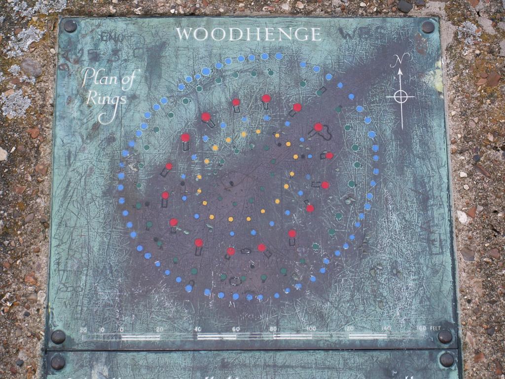
Circles in Wood
Excavations led by Maud Cunnington in 1926 and 1927 uncovered six concentric oval rings of postholes, the outermost measuring approximately 43 meters across. These were surrounded by a flat-bottomed ditch 2.4 meters deep and up to 12 meters wide, with an outer bank roughly 10 meters wide. The posts themselves were substantial timbers, their holes driven deep into the chalk. The site dates to the late Neolithic and early Bronze Age, with the ditch dated to between 2470 and 2000 BC, roughly contemporary with the construction of Stonehenge's stone circle just two miles to the southwest. Pottery recovered during excavation included grooved ware from the middle Neolithic alongside later Beaker-period sherds, suggesting the site was used over many generations.
The Living and the Dead
Why build in wood when your neighbors were hauling stones across a hundred miles of countryside? One compelling theory suggests the choice of material was deliberate and deeply meaningful. Wood rots; stone endures. If Stonehenge was a monument to the dead, a place of ancestors and permanence, then Woodhenge may have represented the realm of the living, transient and renewable. Archaeological evidence supports this division. Bones of butchered pigs found at Woodhenge indicate communal feasting, the consumption of the living world, while Stonehenge appears to have been reserved for ceremonial activity connected to death and ancestors. The same symbolic pairing of wood and stone has been observed at ritualistic megalithic sites on Madagascar, separated by four thousand years and half the world from Salisbury Plain.
A Child in the Center
The most haunting discovery lay at the center of the rings. Cunnington found the burial of a young child, approximately three years old, whose skull had been split. The interpretation of this find has been debated ever since. Was this a sacrifice, a foundation offering placed at the heart of the monument to consecrate it? Or did the child die of natural causes and receive a place of honor? The remains were taken to London for study but were destroyed during the Blitz, making further analysis impossible. Cunnington also found the crouched burial of a teenager in the eastern section of the ditch, opposite the entrance, suggesting that human remains were deliberately placed at significant points within the monument's geometry.
Concrete Markers on the Plain
Today, concrete posts mark where the timber uprights once stood, a functional solution that makes the site's layout comprehensible without pretending to recreate what has been lost. Compared to the crowds at Stonehenge, Woodhenge is quiet, often deserted. Visitors who make the short walk or drive from the main monument find themselves alone with the wind and the chalk, able to stand at the center of the rings and look out across a landscape that has barely changed in contour since the posts were raised. The site sits within the Stonehenge World Heritage Site, just south of the massive henge enclosure at Durrington Walls, and a path possibly connected all three monuments, linking living settlement, timber circle, and stone temple in a single ritual landscape.
From the Air
Located at 51.190N, 1.787W, approximately 2 miles northeast of Stonehenge on Salisbury Plain, Wiltshire. The site is near the A345 road and adjacent to Durrington Walls. From the air, the circular earthwork ditch is faintly visible, and the concrete post markers can be seen at lower altitudes. Nearest airports: EGLS (Old Sarum, 6 nm south), EGBW (Boscombe Down, 4 nm east). Best appreciated as part of the wider Stonehenge landscape from 3,000-5,000 ft.