Writing-on-Stone Provincial Park
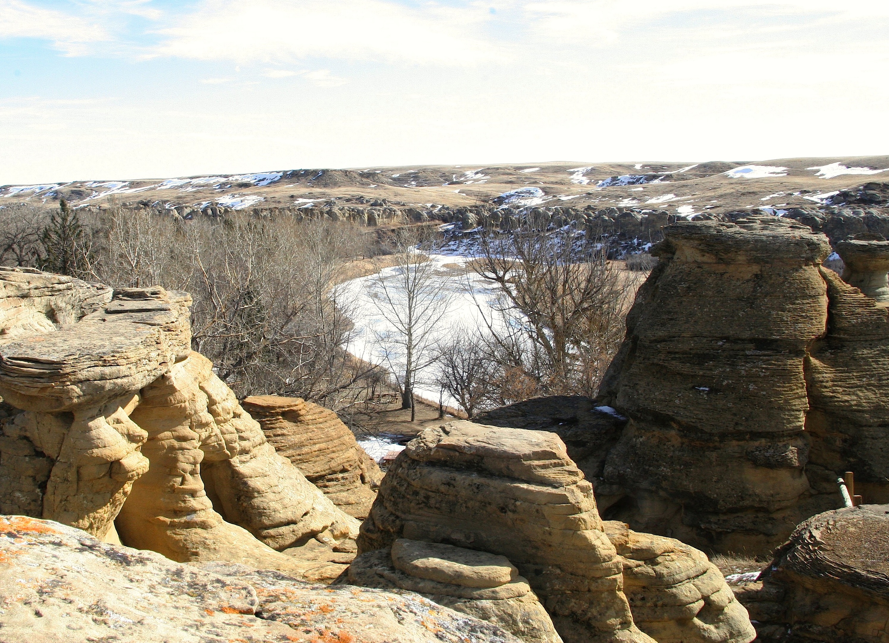
In the Milk River valley of southern Alberta, sandstone cliffs rise from the prairie in strange formations - hoodoos, mushroom rocks, and castellated ridges eroded into shapes that seem designed rather than natural. On these rocks, Indigenous peoples carved and painted images for at least 3,000 years - warriors, horses, shields, ceremonies, and spirit beings. Writing-on-Stone (Áísínai'pi in Blackfoot, meaning 'it is pictured') contains the largest concentration of Indigenous rock art on the North American Great Plains. The site is sacred to the Blackfoot people, who believe the spirits of ancestors dwell here and that the rock art records their communications. The park protects both the geology and the archaeology, a landscape where stone tells stories.
The Geology
The Milk River has carved through soft sandstone for millions of years, creating a valley of remarkable formations. Hoodoos - pillars capped by harder rock that protects softer stone beneath - stand like sentinels. Mushroom rocks balance on narrow stems. Cliff faces display layers of sediment deposited when this land was a seabed. The formations are constantly changing: winter frost cracks the stone, summer heat expands it, wind and water wear it away. The landscape that inspired Indigenous artists continues to evolve; some rock art has been lost to erosion, while the formations themselves grow ever more dramatic.
The Rock Art
More than 50 petroglyph and pictograph sites have been documented in the park, containing thousands of individual images. Petroglyphs are carved into the rock; pictographs are painted on it. The images span at least 3,000 years, from ancient hunting scenes to depictions of European horses and rifles that arrived in the 18th century. Battle scenes show warriors with shields and weapons. Spirit beings appear alongside everyday activities. The art records history, ceremony, visions, and stories. Interpretation requires understanding Blackfoot culture and oral tradition; the images are not merely decorative but meaningful - records of experiences both physical and spiritual.
The Sacred
For the Blackfoot Confederacy - Siksika, Kainai, and Piikani nations - Writing-on-Stone is Áísínai'pi, a place where spirits dwell and communicate. Young men seeking visions came here to fast and pray; the rock art records some of those visions. The formations themselves were understood as alive, inhabited by beings who influenced human affairs. When the park was established, Blackfoot involvement was minimal; today, the nations are partners in interpretation and management. Ceremonies continue at the site. Visitors are asked to respect the sacred nature of the landscape - not to touch the rock art, not to climb formations, not to disturb what has been sacred for millennia.
The Protection
Writing-on-Stone became a provincial park in 1957, protecting the geological formations. The rock art's significance was recognized gradually; the Áísínai'pi National Historic Site was designated in 2004. UNESCO inscribed the site as a World Heritage Site in 2019, recognizing both natural and cultural values. The archaeological preserve is restricted; guided tours provide access to rock art sites. Conservation efforts balance access with protection - the art is fragile, vulnerable to touch, graffiti, and erosion. The partnership between the Alberta government and Blackfoot nations ensures that protection includes the site's continuing sacred function.
Visiting Writing-on-Stone
Writing-on-Stone Provincial Park is located in southern Alberta, 100 kilometers east of Waterton Lakes National Park and 40 kilometers from the US border. The park is open year-round; the campground operates seasonally. Hoodoo Trail and other self-guided paths explore the geological formations. The rock art sites are in the Archaeological Preserve, accessible only by guided tour (book in advance; tours are popular). The visitor center provides context on geology and Blackfoot culture. Lethbridge, the nearest city with full services, is 90 kilometers north. The park is remote; bring supplies. Summer offers the best weather; spring and fall have fewer visitors. Respect the sacred nature of the site.
From the Air
Located at 49.08°N, 111.62°W in the Milk River valley of southern Alberta. From altitude, the park appears as a band of eroded badlands cutting through the prairie along the Milk River - the hoodoos and cliffs contrast with the surrounding flat agricultural land. The US border is visible to the south. The Sweetgrass Hills rise in Montana. Waterton Lakes National Park and the Rocky Mountains are visible to the west. The Milk River winds through the valley, the water that carved these formations over millions of years. The isolation is apparent - this is prairie country with few settlements. The formations that protected and preserved the rock art are visible from altitude as a strip of rough terrain.