Yamashina Mido
Contemporary accounts called it a castle from the very beginning. The Kyohoin Nikki of 1532 records it plainly: "the castle of Yamashina Honganji was built." But this was no samurai fortress. Yamashina Hongan-ji was a Buddhist temple ringed by moats twelve meters wide and four meters deep, its earthen walls studded with watchtowers at regular intervals. Completed in 1483 by the monk Rennyo in what is now Yamashina-ku, Kyoto, the complex served as the headquarters of the Ikko-ikki, an alliance of warrior monks and devout laypeople who rejected samurai authority during Japan's bloody Sengoku period. For nearly fifty years it stood as proof that spiritual conviction, properly fortified, could hold political power at bay.
A Monk's Defiance
Rennyo was the abbot of the Jodo Shinshu sect, a branch of Pure Land Buddhism that preached salvation through faith alone. His teachings galvanized ordinary people, farmers and merchants who had no place in the samurai hierarchy, into a movement called the Ikko-ikki. After the chief Jodo Shinshu temple in Kyoto was destroyed in 1465, Rennyo spent roughly a decade in the provinces. In Echizen Province, the Ikko-ikki had already overthrown the local samurai rulers and established the fortified settlement of Yoshizaki Gobo. Rennyo returned to Kyoto by 1478 with hard-won knowledge of what a religious community needed to survive: walls, moats, and the will to defend them. He chose a site at the confluence of the Shinomiya and Yamashina rivers, a strategic transportation hub where the Tokaido highway met the road to Uji.
Fortress of the Faithful
The fortification Rennyo built was no improvised earthwork. Archaeological excavations have revealed a sophisticated concentric design that actually predates similar layouts in Japan's flatland castles. Workers brought from Kaga Province constructed walls by stacking alternating layers of clay, soil, gravel, and stones, a technique that produced ramparts high enough to require watchtowers. The complex covered roughly one kilometer north to south and 0.8 kilometers east to west, organized into four concentric sections. The innermost ring, the Gohonji, held the main religious buildings. The second ring, the Uchijinai, contained Rennyo's residence and those of his chief followers. The third ring, the Sotoji-nai, housed the merchants and craftsmen who formed the temple town. The outermost section, the Minami-den or Southern Hall, served as Rennyo's retirement quarters, complete with its own double moat, garden, and Buddhist hall.
The Fall
After Rennyo left for Osaka in 1496 to found the Ishiyama Hongan-ji, Yamashina remained the sect's central headquarters for decades. But the Ikko-ikki's growing aggression sowed the seeds of its destruction. In the 1530s, Ikko mobs attacked the Nichiren temple Kenpon-ji in Sakai and the ancient Kofuku-ji and Kasuga shrines in Nara. These assaults enraged adherents of rival Buddhist sects, particularly the Nichiren followers who dominated Kyoto's rising merchant class. The city was still recovering from the devastating Onin War of 1467-1477, and tolerance for religious violence had worn thin. On September 23, 1532, the samurai lords Hosokawa Harumoto and Rokkaku Sadayori led a combined force of warriors and townspeople against the fortress. They overwhelmed its defenses and burned Yamashina Hongan-ji to the ground.
What the Shinkansen Crosses
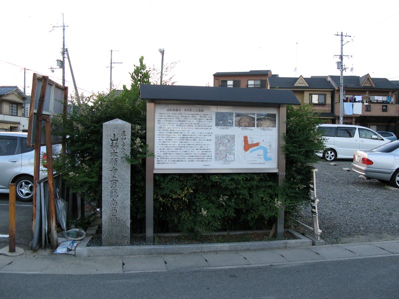
Today, Japan National Route 1 and the Tokaido Shinkansen railway slice through the site where the inner bailey once stood. Residential neighborhoods have swallowed most of the footprint. But fragments survive. A section of the original earthworks remains visible on the east side, and the ruins of the Southern Hall are preserved at Kosho-ji temple. Yamashina Central Park incorporates remnants of the outer fortifications. In 2002, the remains of the Southern Hall and the earthworks received designation as a National Historic Site, formal recognition that beneath the modern city lies the ghost of a place where monks built a castle and held the samurai world at arm's length for half a century. The site is a fifteen-minute walk from Higashino Station on the Kyoto Municipal Subway's Tozai Line.
From the Air
Located at 34.985N, 135.812E in Yamashina-ku, the eastern basin district of Kyoto separated from the main city by the Higashiyama mountains. The site is bisected by the Tokaido Shinkansen rail line, which is a useful visual landmark. Look for the Yamashina Basin east of central Kyoto's urban core, at the confluence area of the Shinomiya and Yamashina rivers. The nearest major airport is Osaka Kansai International (RJBB), about 80 km south. Itami/Osaka International Airport (RJOO) is roughly 35 km west. At low altitude, the earthwork remnants in Yamashina Central Park and the Kosho-ji temple grounds mark the former fortress site.