Yarlung Tsangpo Grand Canyon
In 1880, a man from Sikkim named Kinthup was sent into a gorge no outsider had ever traversed. His mission was simple: release 500 marked logs into the river so the British could confirm that Tibet's east-flowing Tsangpo became India's Brahmaputra. He was sold into slavery, escaped, found work at a monastery, and on three leaves of absence over four years, carved the logs, sent word to the British, and launched them downstream. Nobody was watching. His boss had left India, his letter went astray, and the logs floated into the Brahmaputra unnoticed. The canyon had won again.
Deeper Than Anywhere
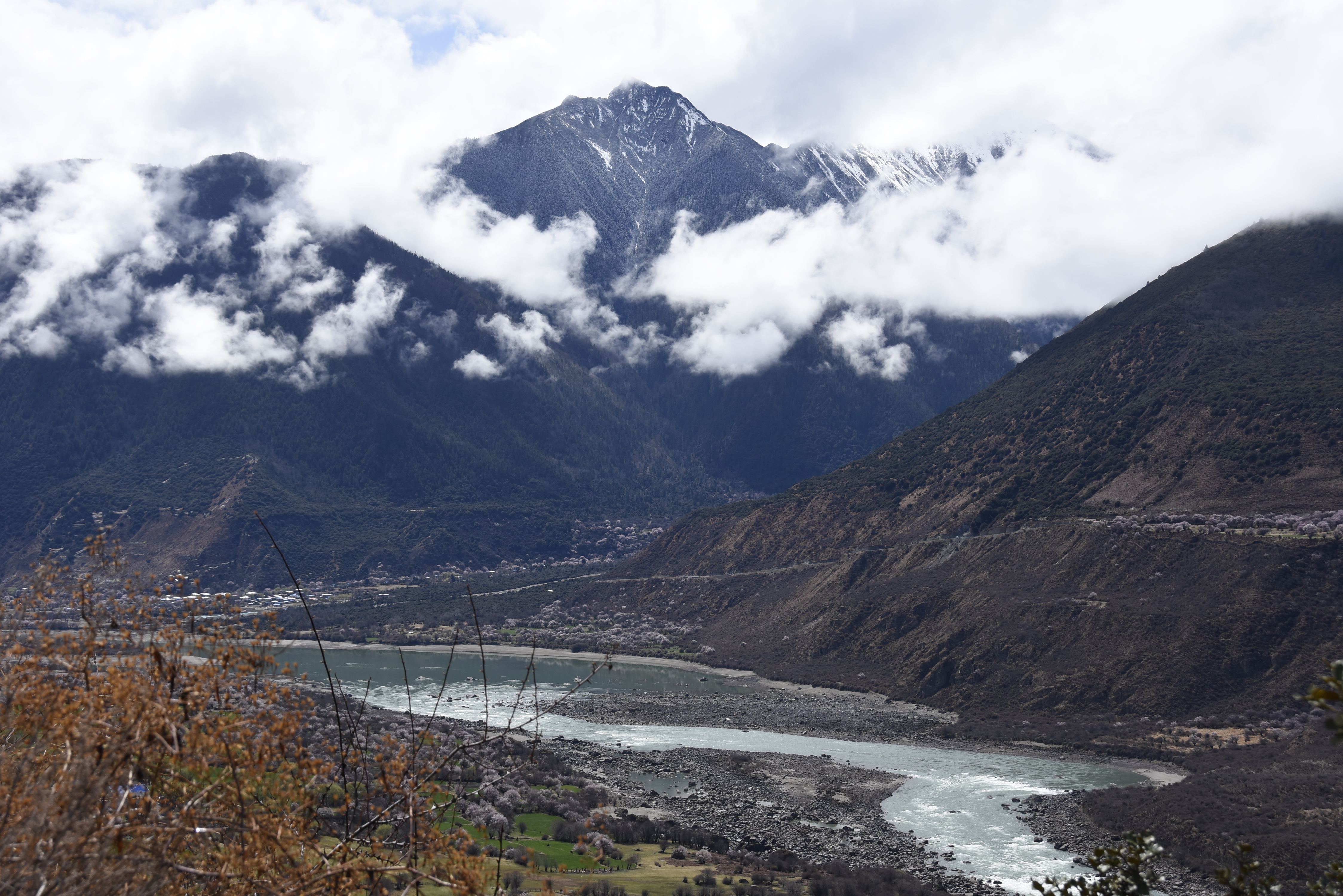
The Yarlung Tsangpo Grand Canyon is the deepest canyon on Earth. At 504.6 kilometers, it is slightly longer than the Grand Canyon in Arizona, but the comparison ends there. Where the Tsangpo bends around Mount Namcha Barwa, the gorge reaches an average depth of 5,000 meters. Its deepest point plunges 6,009 meters, measured from the 7,782-meter summit of Namcha Barwa to the river below. The Tsangpo originates near Mount Kailash, runs east for 1,700 kilometers across the Tibetan Plateau, then makes a dramatic U-turn around Namcha Barwa and cuts through the eastern Himalayas. The river enters the gorge at about 2,900 meters elevation near Pei and drops to 660 meters by the time it crosses into India's Arunachal Pradesh, where it becomes the Brahmaputra.
From Tropical Floor to Arctic Rim
The elevation range within the canyon creates an ecosystem unlike any other in a single drainage. Tropical rainforest lines the lowest reaches, where temperatures have hit 43.6 degrees Celsius near the Indian border. Climb and the forest transitions through subtropical broadleaf, temperate conifer, and subalpine zones before giving way to alpine shrubland and tundra at the highest ridges. The rare takin, a muscular ungulate that looks assembled from spare parts of other animals, roams the mid-elevations. In 2023, researchers discovered a South Tibetan cypress standing 102.3 meters tall in the gorge, making it the tallest known tree in Asia. The canyon's remoteness has kept much of this biodiversity barely explored, a living laboratory shielded by its own impenetrability.
The Everest of Rivers
What Kinthup failed to prove in the 1880s, Frederick Marshman Bailey and Henry Morshead confirmed in 1913: the Tsangpo was the Brahmaputra. In 1924, Frank Kingdon-Ward explored the gorge hoping to find a thundering waterfall that would explain the river's dramatic altitude drop. Instead he found a series of steep cascades, including one he named Rainbow Falls. The area was closed after the Sino-Indian War, reopening in the 1990s. Kayakers soon arrived, drawn by what they called the Everest of Rivers. A 1993 Japanese expedition lost one member. In 1998, a National Geographic-sponsored team attempted the full gorge and lost kayaker Doug Gordon to the high water. It was not until January 2002 that an international team led by Scott Lindgren completed the first full descent of the upper gorge section.
Sacred and Concealed
In 1998, Ken Storm, Hamid Sarder, Ian Baker, and their Monpa guides reached the gorge's largest waterfalls near Tsangpo Badong, estimating the falls at roughly 108 feet. The Pemako region surrounding them is sacred to Tibetan Buddhists, who had deliberately concealed the falls from outsiders, including Chinese authorities. In 2005, Chinese National Geography named them China's most beautiful waterfalls. Two cascades define this stretch: Rainbow Falls at roughly 70 feet and Hidden Falls just downstream at about 100 feet. The gorge may have inspired James Hilton's Shangri-La in his 1933 novel Lost Horizon, and the comparison is earned. This is a place where waterfalls hide behind Buddhist secrecy, where the world's deepest canyon shelters the tallest tree in Asia, and where the river itself remained a geographical riddle for more than a century.
A Dam Larger Than Three Gorges
The Chinese government has declared a Yarlung Tsangpo Grand Canyon National Reservation, but it has also pursued the Medog Hydropower Station, a dam project that would generate an estimated 50 gigawatts of electricity, more than twice the output of the Three Gorges Dam. Construction officially began in 2024. The project has drawn criticism from India, which depends on the Brahmaputra downstream, and from environmental groups concerned about displacement of local populations, destruction of the canyon's unique ecosystems, and the broader consequences of industrializing one of the most ecologically sensitive landscapes on Earth. The tension between preservation and power generation defines the canyon's modern chapter, as the same remoteness that shielded it for centuries now makes it a target for the largest hydroelectric project ever conceived.
From the Air
Located at 29.77N, 94.99E in southeastern Tibet. The canyon wraps around Mount Namcha Barwa (7,782m) and Mount Gyala Peri (7,234m), both visible from high altitude as snow-capped sentinels flanking the gorge. Best viewed above 30,000 feet to appreciate the U-bend of the river. The nearest airport is Nyingchi Mainling Airport (ZUNZ), roughly 100 km west. Expect turbulence and cloud cover from monsoon moisture channeled through the gorge. The river's course from the Tibetan Plateau down to Arunachal Pradesh is a dramatic visual reference.