Yellala Falls
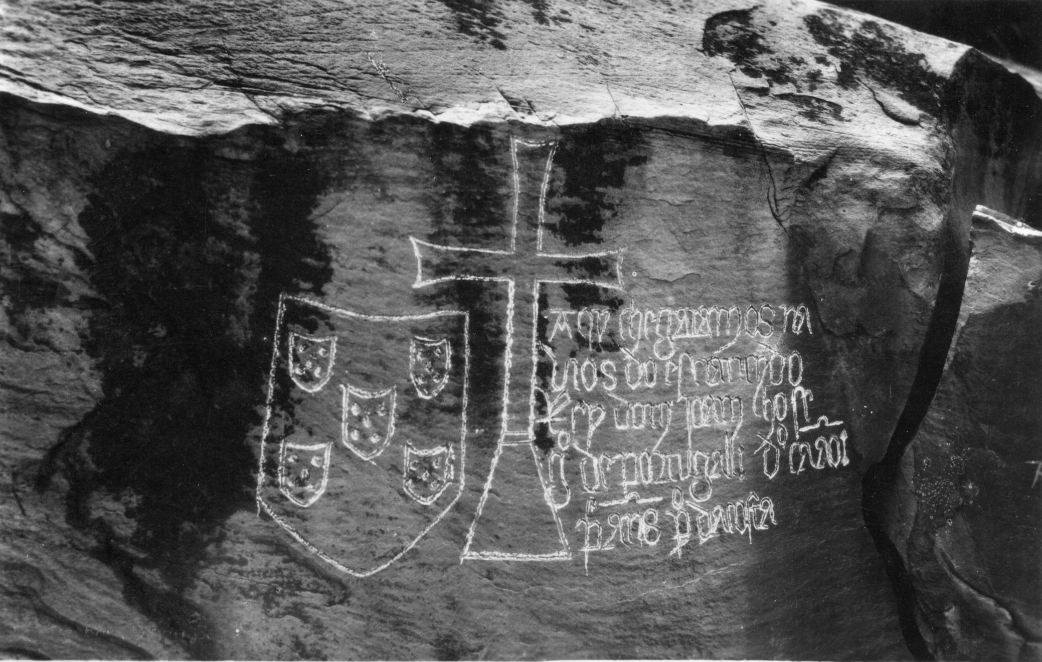
In 1485, the Portuguese explorer Diogo Cao led a party of men up the Congo River as far as a thundering set of rapids and falls. Disease -- probably malaria -- forced them to turn back, but before retreating Cao set a padrao, a stone cross-shaped marker bearing the names of his crew and their king, John II of Portugal. The stone was lost for over four centuries. When it was finally rediscovered in 1911, its inscription was still legible: "Here arrived the ships of illustrious John II, King of Portugal." The falls that stopped Cao are the Yellala Falls, the last and lowest of a long chain of rapids that render 350 kilometers of the Congo River completely unnavigable -- and that have shaped the history, ecology, and exploration of central Africa in ways that few natural features can match.
A River That Broke Through a Continent
The Congo is the second largest river on Earth by volume of water discharged and the deepest river in the world. The drainage basin it commands covers one-eighth of Africa. About five million years ago, the Atlantic continental margin lifted, forming a barrier between the vast interior basin and the sea. A massive lake formed behind this geological wall before the Congo eventually broke through, carving a narrow, rocky channel roughly 350 kilometers long from Kinshasa down to Matadi. The upper portion of this stretch, the Livingstone Falls, drops steeply below Kinshasa. The central portion widens into a navigable, sometimes lake-like passage as deep as 200 meters. Then comes the final, steepest section: enormous rapids at Inga Falls, and then the Yellala Falls, after which the river calms and is navigable to the ocean. About 1.25 million cubic feet of water flows over the Yellala Falls every second.
Explorers, Spirits, and a Vanished Stone
The local people warned Captain James Hingston Tuckey in 1816 that the falls were the residence of an evil spirit, and that anyone who saw them would never see them again. Tuckey -- sent by the Royal Geographical Society to gather intelligence on the slave trade -- visited during the dry season and was underwhelmed by the water volume, though he noted the brutality of the Portuguese slave trade and recorded valuable observations about the region's geography, plants, animals, and people. The Hungarian explorer Laszlo Magyar reached the falls in 1848, then spent five years exploring the region to the south, but his findings received little attention because he had so little contact with the outside world. Richard Francis Burton, visiting in 1863, was more impressed, describing waves forming "for a mile and a half above" before the water plunged thirty feet "spuming, colliding and throwing up foam." He called the thousand-foot trough walls a source of "beauty and grandeur." Henry Morton Stanley followed on April 6, 1880, noting that the fury of the water came not from a dramatic single drop but from the sheer volume forcing itself through a narrow defile.
An Evolutionary Island in Moving Water
The Yellala Falls and the rapids upstream have done something remarkable: they have largely isolated the aquatic life of the Congo Basin from the lower river and the ocean for roughly five million years. That is a significant stretch on an evolutionary timescale, and the result is an extraordinary concentration of species found nowhere else on Earth. The section of river ending at the Yellala Falls contains over 300 species of fish. The cichlid genera Steatocranus, Nanochromis, Lamprologus, and Teleogramma are found only in the Congo basin, with several dozen species confined to the lower Congo alone. Steatocranus species are rheophilic -- adapted to survive in fast-moving water. The four species of Teleogramma exist only in the lower Congo rapids, and genetically distinct populations have been found on opposite banks of the river. Although separated by as little as a mile, currents exceeding 30 miles per hour have prevented interbreeding, turning each bank into its own evolutionary laboratory.
The Barrier That Shaped a Continent's History
For centuries, the Yellala Falls functioned as a locked gate. European navigators could sail up the Congo from the Atlantic as far as Matadi, but the rapids above barred further passage. The interior of the continent remained inaccessible by water, which is why the Congo's vast interior basin was among the last major regions of Africa explored by outsiders. The rapids also explain why Matadi became a critical port, and why the Matadi-Kinshasa Railway was eventually built at such enormous cost: there was no other way to move goods between the navigable upper river and the sea. From the air, the falls are visible as a dramatic narrowing of the river channel, where brown water churns white between walls of rock. The surrounding landscape of tropical savanna stretches toward the Atlantic, still bearing the marks of the geological upheaval that created this barrier millions of years ago.
From the Air
Located at 5.73S, 13.54E on the Congo River, just upstream from Matadi. The falls are visible from altitude as a dramatic narrowing and whitening of the river channel between rocky walls. The port city of Matadi is approximately 8 km downstream. Nearest airport: Tshimpi Airport (FZAM) near Matadi. Recommended viewing altitude: 2,000-4,000 feet AGL for the best perspective on the rapids and surrounding gorge. The river is enormous -- look for the transition from churning white water to calmer brown flow downstream.