Yellowtail Dam
In 1917, Robert Yellowtail sat in a Washington, D.C., hotel room with Chief Plenty Coups and other Crow leaders. They opened a sacred bundle over the incense of buffalo chips brought from animals at the National Zoo and prayed for help. The next day, Congress rejected the proposed appropriation of their land. But Yellowtail knew the government would return. By the 1940s, federal engineers were back with new plans for a dam in Bighorn Canyon. Yellowtail became the loudest voice against it, warning that the canyon was sacred to his people. The Bureau of Reclamation built it anyway, then named the 525-foot structure after him.
A Tribe Divided
The arguments over the dam split the Crow into factions. The Mountain Crows sided with Yellowtail in opposition. The River Crows saw potential in the electricity revenues the government promised. For a time, the tribe considered leasing the land for fifty years at one million dollars annually. In the end, they sold it outright for 2.5 million dollars, and controversy burned for decades afterward. Robert Yellowtail had already made headlines in 1934 when he became the first Native American to serve as superintendent of his own tribe's reservation. His opposition to the dam that would bear his name cemented his legacy as a defender of Crow sovereignty, even in defeat. The irony of the naming was not lost on anyone who knew the history.
Engineering the Impossible
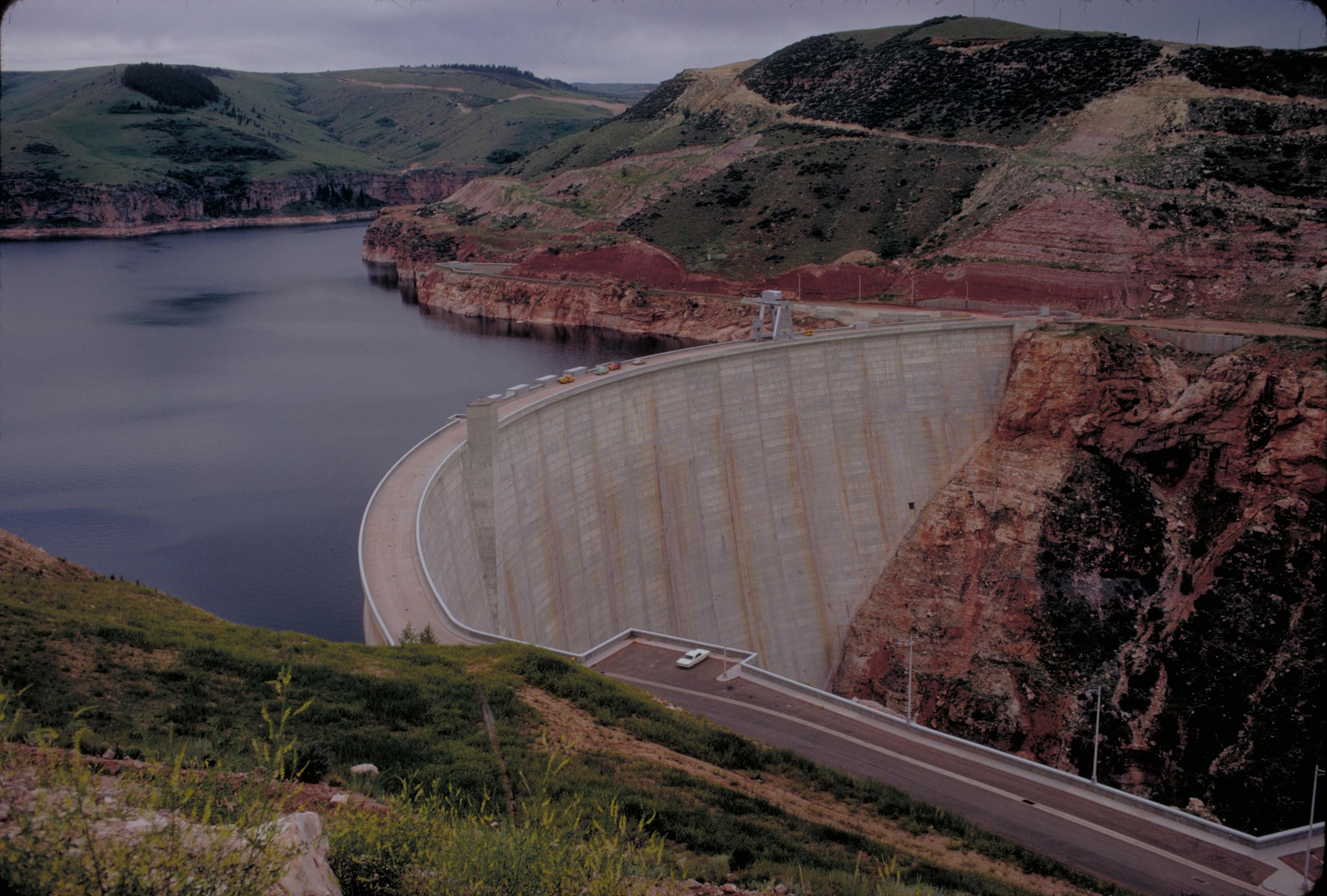
Morrison-Knudsen, the Boise-based contractor that had built Hoover and Grand Coulee dams, landed the contract in 1961. Workers first bored a diversion tunnel through solid rock, then raised a cofferdam to reroute the Bighorn while they poured concrete. Six years later, in December 1967, the arch dam was topped out. For a structure of its scale, the construction claimed only one life. The dam rises 525 feet from bedrock to crest, its curved face holding back Bighorn Lake's waters. Four Francis turbines at the base, each rated at 87,500 horsepower, generate 250 megawatts of electricity. The powerhouse began operations in 1966, a year before the dam was even complete, feeding peaking power into Montana's grid.
Cold Water, New Life
Before the dam, the Bighorn was a warm-water river. After it, something unexpected happened. Water released from the depths of Bighorn Lake runs cold, and that temperature shift transformed the downstream ecosystem. Rainbow and brown trout now spawn where warm-water species once dominated. The lower Bighorn became one of the finest wild trout fisheries in the United States. Average trout run large here, and the fishing lodges of Fort Smith have built an industry on the dam's unintended gift. Yet the transformation came at a cost. The dam traps sediments that once built islands and sandbars downriver, flattening the Bighorn's character. The fishery thrives in altered conditions that have erased much of the river's original habitat.
Two States, One Lake
Bighorn Lake extends upstream from the dam, crossing the Montana-Wyoming border. Nearly two-thirds of the reservoir's surface area lies in Wyoming, while the trout fishery downstream is entirely Montana's concern. This geography has created ongoing tension. Wyoming wants higher lake levels for boating and water skiing. Montana wants steadier releases to keep the trout healthy. A prolonged western drought forced the Bureau of Reclamation to reduce downstream flows, and the fishing industry on the lower Bighorn declined by over forty percent. Wyoming's recreational usage dropped even more steeply, by over sixty percent. The bureau now tries to balance both interests, maintaining minimum flows below the dam while keeping the lake at levels that satisfy neither state completely.
The Afterbay Solution
Because the power station operates on peaking demand, releases from Yellowtail Dam can vary dramatically throughout a single day. To smooth these fluctuations, engineers built a smaller dam downstream, the Yellowtail Afterbay. This secondary structure captures the irregular flows and releases a constant stream into the Bighorn, creating the stable conditions trout need. The Afterbay reservoir has become a destination in its own right, popular for trout fishing from shore and by boat. Above it all, the main dam stands as a monument to mid-century ambition and tribal loss, generating power, holding back floods, and bearing the name of a man who never wanted it built. Robert Yellowtail died in 1988, having lived to see his name etched into concrete that drowned his people's sacred canyon.
From the Air
Located at 45.31N, 107.96W in Big Horn County, Montana, approximately 45nm southeast of Billings. The concrete arch dam is visible as a pale crescent against the dark canyon walls, with Bighorn Lake extending south into Wyoming. The smaller Afterbay Dam lies just downstream. Best viewed from 4,000-6,000 feet AGL approaching from the east or west to appreciate the dam's scale against the canyon. Nearby airports: Billings Logan International (KBIL) 45nm northwest, Sheridan County Airport (KSHR) 50nm southeast. Morning light highlights the dam face; afternoon shadows deepen the canyon contrast.