Yenisei
In Tuvan, the word for river is xem. The Yenisei earned its ancient name so thoroughly that the word itself became synonymous with what a river is. Rising as the Mungaragiyn-gol in Mongolia, gathering strength through Lake Baikal, passing the Krasnoyarsk Dam, and finally emptying into the Kara Sea between the Gyda and Taymyr Peninsulas, the Yenisei runs 5,075 kilometers from source to mouth. It is the fifth-longest river system in the world and the largest to drain into the Arctic Ocean. More than a waterway, it is a continental divide: everything west is the flat Western Siberian Plain, everything east is the elevated Central Siberian Plateau.
Ancient Names, Ancient People
The first written mention of this river appears in 7th-century Tang dynasty chronicles as "Kem," recorded when Chinese emissaries made contact with the Yenisei Kyrgyz. The name appears across centuries and scripts: Jian shui in the Book of Zhou, Qian he in the 14th-century History of Yuan, and Kem on Chinese imperial atlases as late as 1769. Nomadic peoples had long lived along its banks. The Ket people and the Yugh people are among the oldest inhabitants, part of the Yeniseian language family. Today, the Ket number about 1,000 and are the sole survivors of peoples who once populated central southern Siberia along the river. Their extinct relatives, the Kotts, Assans, Arins, Baikots, and Pumpokols, lived farther upriver before being absorbed into the expanding Russian state between the 17th and 19th centuries.
Steamers, Tsars, and Prisoners
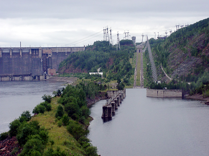
River steamers first reached the Yenisei in 1864, hauled across the icy Kara Sea from the Netherlands and Britain. The steamship Thames tried to explore the river in 1876, overwintered, was damaged by ice, and eventually wrecked. Success came with the steamers Frazer and Express in 1878, followed by the Moscow, which managed to haul supplies in and wheat out. Imperial Russia saw the river as a lifeline for landlocked Siberia. The steamer St. Nicholas carried future Tsar Nicholas II on his voyage east, and later conveyed Vladimir Lenin to exile. During construction of the Trans-Siberian Railway, Captain Joseph Wiggins sailed the Orestes upriver with rail cargo in 1893. But the route proved treacherous: the Ob and Yenisei mouths stretch hundreds of kilometers through shallow, ice-bound, wind-battered inlets. After the railway's completion, the Arctic sea route fell quiet.
A River of Superlatives
The Yenisei proper, from the confluence of the Great and Little Yenisei at Kyzyl to its mouth, stretches 3,487 kilometers. Its drainage basin covers 2,580,000 square kilometers. The river reaches a maximum depth of 200 feet and averages 45. Lake Baikal, the deepest and oldest lake in the world, feeds into the upper system. At the estuary's southern end, the Brekhovskie Islands sprawl across 1,400,000 hectares of wetland, providing nesting habitat for rare and endangered waterfowl. Fridtjof Nansen visited the northeasternmost island, Nosonovskij Ostrov, in 1913. The Yenisei basin supports 55 native fish species, including two found nowhere else on Earth. And the Taimyr reindeer herd, the world's largest, migrates to winter grazing ranges along the river, a population that peaked at over one million.
The Geopolitical Current
Rivers shape borders as readily as they carry water. During World War II, Nazi Germany and the Japanese Empire agreed to divide Asia along the Yenisei, a line of partition that was never realized but speaks to the river's symbolic weight as a continental boundary. In the Cold War, the secret city of Krasnoyarsk-26, now known as Zheleznogorsk, discharged radioactive waste from its plutonium production facility into the river. The contamination persists. In June 2025, a ship towing barges ran aground in Kazachinsky District, spilling 30 metric tons of diesel fuel across 50 kilometers of shoreline. The Yenisei has endured these wounds, but they accumulate.
From the Air
Flying north along the Yenisei is to watch Siberia unfold in its true scale. The river begins in the mountains of Tuva, threads through Khakassia, passes the city of Krasnoyarsk, and then enters a vast, increasingly treeless landscape. The tributaries alone are enormous: the Angara, the Podkamennaya Tunguska, the Nizhnyaya Tunguska. Near Dudinka, the river widens toward its gulf, and the tundra stretches to every horizon. In 2001, an Australian-Canadian team became the first recreational expedition to navigate the Yenisei's entire length, including its violent upper tributary in Mongolia. The journey took months. From a cockpit, you can trace the same route in hours, but the emptiness below remains just as absolute.
From the Air
The Yenisei runs roughly north-south through central Siberia from approximately 51N to 72N. Key waypoints include Kyzyl (UNKY) at the confluence of the Great and Little Yenisei, Krasnoyarsk (UNKL) where the river passes the Krasnoyarsk Dam, and Dudinka (UODD) near the estuary. The river is an unmistakable navigation reference, dividing the flat Western Siberian Plain (west) from the Central Siberian Plateau (east). The Yenisei Gulf opens into the Kara Sea near 72.3N, 80.5E. Norilsk (UOOO) lies near the river's lower reaches on the Taymyr Peninsula.