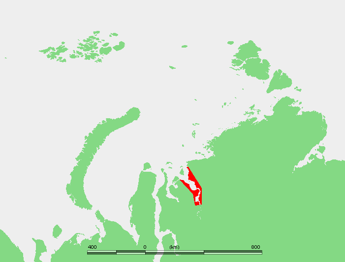
Yenisei Gulf
Nine months of the year, the Yenisei Gulf is a white plain. Ice seals the estuary shut from autumn through late spring, and only icebreakers keep shipping lanes open during the darkest months. Then, briefly, the gulf remembers it is water. The ice fractures, floes calve and drift, and the Yenisei River completes its 5,000-kilometer journey from Mongolia to the Kara Sea through this long, wide mouth. It is one of the largest estuaries in the Arctic, and one of the loneliest places on Earth.
Where the River Becomes the Sea
The Yenisei Gulf begins forming north of Dudinka, around latitude 70 degrees 30 minutes north, where the river widens dramatically in a roughly north-south direction. The estuary stretches northward to approximately 72 degrees 30 minutes north, near Sibiryakov Island, where the fresh water finally mingles with the Kara Sea. The whole region is bleak and sparsely inhabited. Settlements sit on permafrost ground, and the only vegetation is mosses, lichens, and sparse grass. There are no trees, no hedgerows, no fences. The landscape is a study in horizontal lines: water, ice, tundra, sky.
Islands in the Current
At the gulf's southern end, where the river pours into the estuary, lie the Brekhovsky Islands, flat and low, surrounded by lakes, swamps, and the many arms through which lesser tundra rivers drain into the Yenisei basin. Farther north, the water turns brackish and the estuary opens into a clear expanse. Three small islands cluster near the middle: the Bolshoi Korsakovsky group, with Burnyy Island sitting dead center and Chaishnyy hugging the shore. Farther northwest, close to the eastern bank, lies Krestovsky Island, named after the Russian writer Vsevolod Vladimirovich Krestovskiy, who lived from 1840 to 1895. These islands are uninhabited, shaped by current and ice into forms that shift with the seasons.
Life at the Edge
Despite the brutal conditions, the gulf sustains life that has adapted to extremes. Beluga whales inhabit the coastal waters, drawn by the mixing of fresh and salt water that concentrates nutrients and prey. The Willem Barents Biological Station, a polar research facility, sits northeast of Meduza Bay at the northern end of the river's mouth, monitoring the ecology of an environment that most of the world has never seen. The entire gulf and its islands fall within the Great Arctic State Nature Reserve, the largest nature reserve in Russia. Scientists study dissolved organic matter in the estuary, salt intrusions in the brackish zone, and the effects of climate change on an ecosystem balanced on the knife's edge between frozen and flowing.
Winters That Define Everything
The climate here is severe in the way that only the high Arctic can manage. Winters are long, bitter, and relentless, defined by blizzards that scour the ice flat and gales that drive wind chill to extremes. Even in summer the gulf never fully clears of ice floes. Shipping is a seasonal affair governed by the rhythm of freezing and thawing, and in winter, icebreakers work constantly to keep routes open for vessels serving the Northern Sea Route. For a few weeks each year, the spring melt turns the estuary into a churning corridor of broken ice, and the port at Dudinka floods so thoroughly that its cranes must be relocated to higher ground. Then the freeze returns, and the gulf becomes white again.
From the Air
Located at 72.30N, 80.50E at the mouth of the Yenisei River entering the Kara Sea. Visible from high altitude as a massive estuary stretching roughly north-south. Sibiryakov Island marks the northern mouth. The nearest settlement is Dudinka (UODD) to the south. The Brekhovsky Islands are visible at the southern end where the river widens. Expect ice cover for most of the year, with open water only from roughly June through September. Part of the Great Arctic State Nature Reserve.