Yodo River
Emperor Shirakawa, who ruled Japan in the late eleventh century, once listed the three things in the world that refused to obey his will: the warrior monks of Mount Hiei, the roll of dice in sugoroku, and the flooding of the Kamo River -- a tributary of the Yodo. For over a thousand years, the river that changes its name three times on its journey from Lake Biwa to Osaka Bay has been both the lifeblood and the nemesis of Japan's most important cities. The Yodo River does not simply flow through Japanese history. It is the current on which that history was carried.
A River of Many Names
The Yodo begins where Japan's largest freshwater lake empties southward. At its source in Otsu, Shiga Prefecture, the water leaving Lake Biwa is called the Seta River. A dam regulates the outflow, controlling the lake level that once tormented generations of farmers and monks. As the Seta crosses into Kyoto Prefecture, it becomes the Uji River, the waterway that features prominently in the final chapters of The Tale of Genji, Murasaki Shikibu's eleventh-century masterpiece. The Uji then converges with the Katsura River, flowing down from the mountains of Kyoto, and the Kizu River, arriving from Mie Prefecture. At this three-river confluence, the combined waterway takes its final name -- the Yodo -- and flows south through Osaka and into Osaka Bay. In the heart of Osaka, an artificial channel diverts part of the flow; the original course survives as the Kyu-Yodo River, the "Former Yodo," a ghost of the river's older path through the city center.
The Reason Kyoto Exists
The choice of Heian-kyo -- modern Kyoto -- as Japan's imperial capital during the Heian period was driven in part by the Yodo River. The waterway provided a direct transportation corridor from the new capital south to Osaka and its outlet on the Seto Inland Sea, connecting the seat of political power to maritime trade routes. But the river that enabled the city also threatened it. During the Nara period, the monk Gyoki attempted to widen a bottleneck on the Seta River where a small mountain jutted into the channel, choking the flow and causing upstream flooding around Lake Biwa. He ultimately abandoned the plan, fearing that increasing the downstream flow would simply move the flooding problem to other villages. The Yodo basin's position at the center of Japanese politics, culture, and economy meant that flood control was not an engineering problem -- it was a matter of national survival.
Hideyoshi's Great Embankment
Toyotomi Hideyoshi, who unified Japan during the Sengoku period, saw the river as both obstacle and opportunity. When he moved to Fushimi in his later years and completed Fushimi Castle in 1594, he undertook massive flood control works, rerouting sections of the Uji and Yodo rivers. His signature achievement was the Taiko Embankment, constructed on the right bank of the Uji River. The bank ran in a straight line for roughly 400 meters, built using varied construction methods adapted to the terrain, with sluice gates at 90-meter intervals to regulate water flow. The stone-walled gates, filled with broken stone inside, resemble the walls of a castle. Flooding gradually buried the embankment over the centuries, which paradoxically preserved it in remarkable condition. Designated a National Historic Site in 2009, the Taiko Embankment survives as one of Japan's most significant examples of premodern hydraulic engineering.
The 808 Bridges of Water City
During the Edo period, the river system transformed Osaka into Japan's commercial engine. Tokugawa Ieyasu ordered the excavation of the Kamo River for transporting materials to build the Great Buddha Hall of Hoko-ji in Kyoto. The Takase River was dug as a permanent canal. In Osaka, the Dotonbori canal was excavated, and as the city rebuilt after the devastating Siege of Osaka, water transportation and bridges proliferated. Osaka earned the nickname "city of 808 bridges," contrasting with Edo's boast of "808 towns." By 1858, an estimated 50 boats carried roughly 1,500 passengers daily between Osaka and Fushimi. A steamboat trip between the two cities took twelve hours. But the economic boom came at an ecological cost. Deforestation for firewood, charcoal, and new rice fields stripped the river basin's mountains of forest cover. Sediment poured into the waterways, raising riverbeds and worsening floods. The Shogunate banned the mining of tree stumps in three provinces in 1660 -- an early act of environmental regulation born of desperation.
Still Flowing, Still Feeding
The arrival of trains in the 1870s ended the Yodo's centuries-long role as the primary transportation artery between Osaka and Kyoto. More than 50 bridges now cross the river, carrying cars and rail lines over a waterway that still serves as a source of irrigation water and hydroelectric power. Today the Uji River sections are popular fishing spots in summer and autumn. But the river's deepest legacy is the civilization it built. The Yodo connected Lake Biwa to the sea, Kyoto to Osaka, the emperor to commerce. Every major chapter of Japanese history -- from the Heian court to the Sengoku unification to the Edo merchant economy -- played out along its banks. The water still carries that weight, even as the city around it has changed beyond recognition.
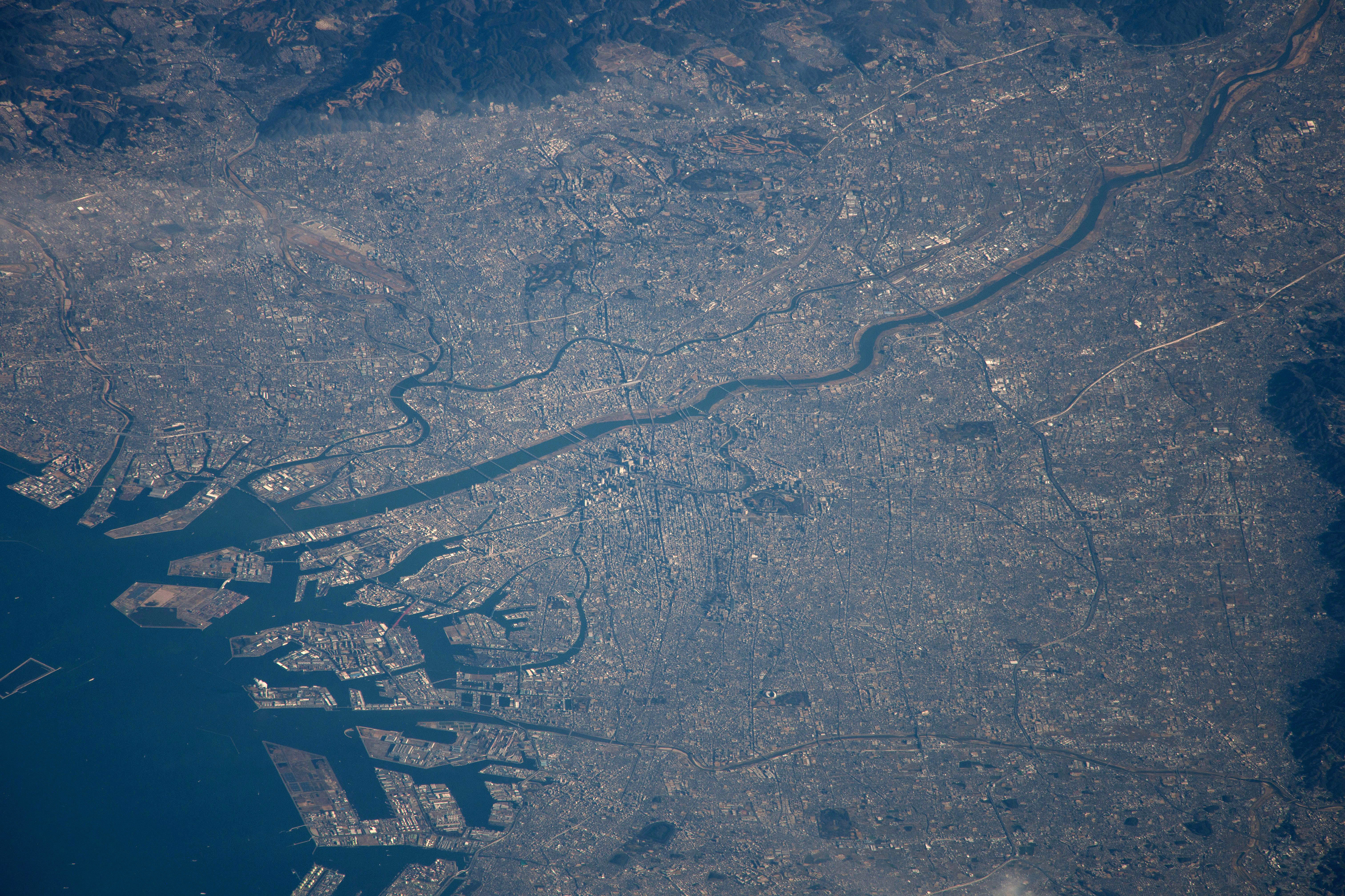
From the Air
The Yodo River is a major visual navigation feature across the Osaka-Kyoto corridor. The mouth empties into Osaka Bay at approximately 34.683N, 135.420E. The river is clearly visible from cruising altitude, flowing generally east-west through Osaka's urban landscape. Follow the river upstream to trace the route toward Kyoto. Osaka Itami Airport (RJOO) lies roughly 5 nm north of the river's lower course. Kansai International Airport (RJBB) is approximately 25 nm to the south. The three-river confluence of the Uji, Katsura, and Kizu rivers is a distinctive geographical feature visible at moderate altitudes southeast of Osaka.