The Creek That Built the Falls
For most of its 15 miles, Yosemite Creek is unremarkable. It meanders across granite slabs and through alpine meadows in the high country above Yosemite Valley, looking like any number of Sierra Nevada streams -- clear, shallow, quiet. Then it reaches the rim. In a single, breathtaking transition, this placid creek becomes the source of Yosemite Falls, plunging 2,425 feet in a series of drops that rank among the tallest waterfalls on Earth. The contrast between the gentle creek above and the violent spectacle below is one of Yosemite's most dramatic geological stories, and it has everything to do with ice, time, and a landscape still adjusting to the loss of its glaciers.
Born at the Grant Lakes
Yosemite Creek begins its journey at the Grant Lakes, a cluster of alpine tarns tucked into the granite country north of Yosemite Valley. From there it flows southwest, gathering snowmelt from a 43-square-mile watershed that is, geologically speaking, almost entirely bare rock. Glaciers stripped this basin to the bone during the last ice ages, scraping away the soil that might otherwise have acted as a sponge. The consequence is a creek that is spectacularly responsive to the seasons. When the Sierra snowpack melts in late spring, Yosemite Creek swells and the falls roar. By August or September in most years, the creek thins to a trickle and the falls go silent. The watershed has no capacity to store what it receives -- everything pours through in a rush, then stops.
An Ancient Course Abandoned
The creek did not always follow its current path over the valley rim. Around 130,000 years ago, Yosemite Creek flowed through an older channel slightly to the west, cascading down a steep ravine rather than free-falling over a cliff. Glacial activity during the intervening ice ages resculpted the valley walls and diverted the creek to its present course, creating the sheer drop that makes Yosemite Falls possible. The old channel is still visible in the landscape -- it is the steep ravine that the Yosemite Falls Trail now follows, a popular but grueling 3.5-mile climb from the valley floor to the rim. Hikers ascending that trail are literally walking up the creek's abandoned staircase, a route that water carved long before anyone thought to put switchbacks on it.
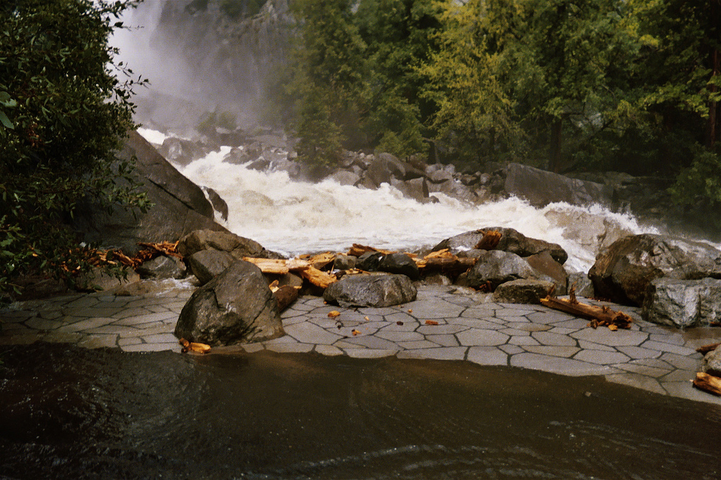
The Moment of Falling
At the rim, Yosemite Creek passes through Eagle Creek Meadow, a flat expanse where the water slows and meanders as if unaware of what comes next. Then the ground drops away. The Upper Yosemite Fall sends the creek 1,430 feet straight down in a single plunge -- a hanging valley pouring its contents into a much larger, glacially deepened trough. The water hits ledges and breaks apart into mist before reforming to tumble through the Middle Cascades, a series of four smaller plunges totaling 675 feet that most visitors never see because the gorge that contains them is too narrow and steep for safe access. Finally, the Lower Fall adds another 320 feet, depositing Yosemite Creek at the valley floor, where it flows quietly into the Merced River near Yosemite Village. From alpine tarn to river confluence, the creek drops nearly half a mile in elevation.
When the Water Stops
The disappearance of the falls each summer is one of Yosemite's most striking seasonal transformations. Visitors who arrive in July expecting a thundering cascade often find a dry cliff face streaked with moisture stains and nothing more. This absence has created an unusual opportunity for a handful of rock climbers, who have scaled the exposed cliff beneath the Upper Fall during dry periods -- a route that is inaccessible and lethal when water is flowing. The undertaking is extraordinarily dangerous even when the falls are dry, because a single afternoon thunderstorm in the high country can restart the creek with little warning, sending water over the rim and sweeping anything off the rock face below. The creek's lack of a buffering watershed -- the same bare-granite basin that makes the spring flow so dramatic -- is precisely what makes it so unpredictable.
A River of Rock and Light
From altitude, Yosemite Creek is visible as a thin silver line threading through pale granite, easy to trace from the dark pools of the Grant Lakes southwest to the valley rim. The creek's watershed is one of the most geologically exposed landscapes in the Sierra Nevada -- a terrain of polished rock, glacial erratics, and scattered lodgepole pines where the bones of the mountain lie close to the surface. In spring, when snowmelt fills every crease in the granite, the creek and its tributaries turn the entire basin into a network of reflective channels. By autumn, the same landscape is dry and quiet, the creek bed empty, the falls a memory. Yosemite Creek is a reminder that even the most iconic features of the natural world are not permanent fixtures but seasonal performances, shaped by water that arrives, transforms everything it touches, and then simply goes away.
From the Air
Yosemite Creek runs from the Grant Lakes (approx. 37.85N, 119.60W) southwest to the Yosemite Valley rim at 37.756N, 119.597W, where it becomes Yosemite Falls. Best viewed from 5,000-8,000 ft AGL, looking east along the valley. The creek itself is a thin line on granite; the falls are the dramatic feature visible from distance. Nearest airports: Mariposa-Yosemite (KMPI, 30 nm SW), Merced Regional (KMCE, 55 nm SW). Spring offers peak water flow and best visibility of the falls.