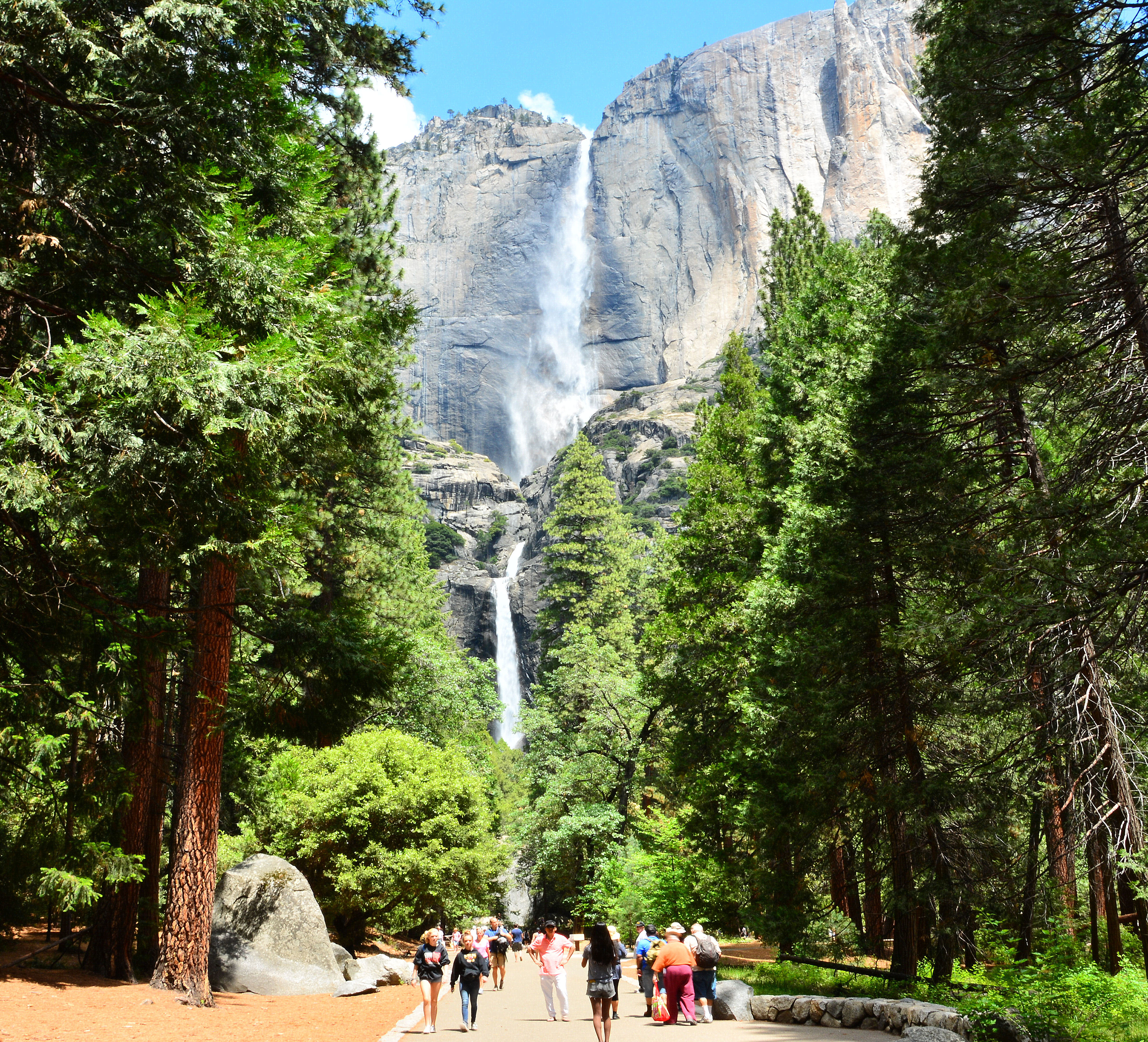
Cholock: The Fall That Swallowed a House
The Ahwahneechee called it Cholock -- simply, "the fall." No modifier was needed. Their main village stood at its base, and they believed the plunge pool was home to the Poloti, a group of spirits who did not appreciate trespassers. One Ahwahneechee story tells of a woman who went to the pool to fetch water and drew up a pail full of snakes. That night, a powerful wind sucked her house into the pool, taking her and her newborn child with it. It is a story about boundaries and respect, and anyone who has stood close enough to the Lower Fall to feel the ground vibrate will understand why the Ahwahneechee treated this place with caution. Yosemite Falls drops 2,425 feet from rim to valley floor -- a cascade divided into three stages that together make it the tallest waterfall in the park.
The Upper Plunge
The spectacle begins at the lip of a hanging valley, where Yosemite Creek -- after meandering through the gentle terrain of Eagle Creek Meadow -- abruptly runs out of ground. The Upper Yosemite Fall is a single free-falling plunge of 1,430 feet, more than half the total drop. At peak flow in late spring, the volume of water hitting the base generates a roar audible across the valley and a mist cloud that drifts hundreds of feet from the impact zone. The force is literal: the concussion of water on rock sends vibrations through the granite. Trails lead to both the top and the base of the upper fall, but neither viewpoint fully prepares visitors for the scale. Standing at the top, the creek seems modest, almost gentle. Standing at the bottom, looking up through spray at a column of water taller than the Empire State Building, the word "creek" feels absurd.
The Hidden Middle
Between the two famous plunges lies a section most visitors never see. The Middle Cascades consist of four smaller drops totaling 675 feet -- more than twice the height of the Lower Fall -- compressed into a narrow, constricted gorge with no public access. Most viewpoints in the valley miss them entirely, and the few vantage points available along the Yosemite Falls Trail require careful attention to spot. The gorge's walls close in tightly here, channeling the water through a series of chutes and ledges that break the flow into white chaos. Hikers who have attempted to leave the trail and descend toward the cascades have found themselves stranded on steep, water-slicked rock, requiring expensive helicopter rescues. The Middle Cascades are Yosemite Falls' best-kept secret -- a section as tall as a modest skyscraper, hidden in plain sight within one of the most visited parks on Earth.
The Accessible Giant
The Lower Yosemite Fall drops 320 feet into a plunge pool surrounded by talus -- massive blocks of fallen rock made treacherous by constant humidity and spray. This is the falls that most people experience, because a short, paved trail from Yosemite Lodge leads directly to a viewing area at its base. The accessibility is both a gift and a hazard. The wet rock draws visitors closer than they should go, and the jumbled boulders conceal drop-offs that the mist makes difficult to judge. Still, this is where Yosemite Falls becomes personal rather than panoramic. At the viewpoint, you do not see the falls so much as feel them -- the cold air displaced by falling water, the percussive sound that vibrates in your chest, the fine spray that soaks clothing within minutes. Yosemite Creek, having survived its 2,100-foot descent, flows out of the pool and joins the Merced River a short distance away, quiet again.
The Vanishing Act
In all but the wettest years, Yosemite Falls ceases to flow entirely by late summer. The 43-square-mile watershed that feeds Yosemite Creek is a glacier-scraped granite basin with almost no capacity to store water, so the falls are utterly dependent on snowmelt. When the snow is gone, the falls are gone. This seasonal disappearance has created one of Yosemite's more extreme recreational niches: a small number of rock climbers have scaled the dry cliff face beneath the Upper Fall, ascending rock that is impossible to reach when the water is running. The danger is acute. A single afternoon thunderstorm in the high country can restart the creek in minutes, sending a wall of water over the rim without warning. The climbers gambling on dry rock are betting against the weather in a watershed designed to deliver every drop of rain to the cliff edge as fast as possible.
Trails Worn Deep
The most popular route to the top of the falls begins near Camp 4, the legendary climbers' campground at the base of the valley's north wall. The trail climbs 3.6 miles and roughly 2,700 feet of elevation through a series of steep, exposed switchbacks -- a hike that typically takes two to four hours up and earns its reputation as one of the most demanding day hikes in the park. An alternate route descends from Tioga Road to the north, approaching the falls from above. At the summit, hikers reach a railing overlooking the brink of the Upper Fall, where the creek slides over polished granite and drops into space. The view down is vertiginous. The view out encompasses most of Yosemite Valley -- the meadows, the river, the distant profile of Half Dome. It is a perspective the Ahwahneechee knew well, from a place they understood held power long before anyone built a trail to it.
From the Air
Located at 37.755N, 119.597W on the north wall of Yosemite Valley. The falls are best viewed from the south or southeast at 4,000-6,000 ft AGL. In spring (April-June), the white ribbon of the Upper Fall is visible from considerable distance against the dark granite. By late summer the falls may be dry and invisible from altitude. Nearest airports: Mariposa-Yosemite (KMPI, 30 nm SW), Merced Regional (KMCE, 55 nm SW). Morning light illuminates the falls directly; afternoon shadows can obscure the lower sections.