Yu Shan
NIITAKAYAMANOBORE 1208. 'Climb Mount Niitaka, December 8th.' That was the coded signal transmitted by the Imperial Japanese Navy to launch the surprise attack on Pearl Harbor on 7 December 1941. Mount Niitaka - 'New High Mountain' - was the Japanese name for Yu Shan, Taiwan's highest peak at 3,952 meters above sea level. Because Taiwan was then part of the Japanese Empire, this summit was technically the highest point in all of Japan, surpassing Mount Fuji by 176 meters. The mountain that provided the code word for one of history's most consequential military operations now graces Taiwan's NT$1,000 banknote - a symbol transformed from imperial conquest into national identity.
A Mountain of Names
Every ruler of Taiwan has named this peak. The Bunun people, who have lived in its shadow for centuries, call it Tongku Saveq - 'highest peak' or 'sheltering peak.' The Kanakanavu know it as Tanungu'incu; the Paiwan call it Kanasian. In 1857, Captain W. Morrison of the American steam freighter Alexander sighted the mountain while departing Anping Harbor near present-day Tainan, and his logbook entry gave European mapmakers the name 'Mount Morrison' - which was erroneously attributed to the missionary Robert Morrison. When Japan colonized Taiwan, new surveys proved the peak was 176 meters higher than any mountain in the Japanese archipelago, earning it the name Niitakayama. After Japan's defeat, the Republic of China bestowed the Chinese name Yu Shan - 'Jade Mountain' - for the way thick winter snow makes the summit gleam like stainless jade.
From Ocean Floor to Summit
Yu Shan was once beneath the sea. The area rose to its current height through the collision of the Eurasian Plate and the Philippine Sea Plate, a tectonic process that continues to this day. As recently as seventeen thousand years ago, permanent ice caps covered Taiwan's highest peaks, extending down to 2,800 meters thanks to the wet climate. Today, the nearest glaciers to the Tropic of Cancer are on Mexico's Iztaccihuatl volcano, far to the west. The ocean waters off Taiwan's east coast plunge at a grade of 1:10, reaching depths of more than 4,000 meters just 50 kilometers offshore. This dramatic contrast - from abyssal ocean trench to nearly 4,000-meter summit in such short horizontal distance - makes Taiwan one of the steepest islands on Earth.
The Ark of Taiwan
Academics call Yu Shan 'the ark' because it serves as a repository for the island's rare species. The elevation difference from foothills to summit spans 3.6 kilometers, creating climate zones ranging from subtropical to alpine within a single national park. Preliminary surveys have counted 130 species of birds, 28 species of mammals, 17 species of reptiles, 12 species of amphibians, and 186 species of butterflies. One-third of Taiwan's endemic species find habitat here, including the Formosan black bear, the Formosan serow, Reeves's muntjac, the Formosan rock macaque, and the Formosan blue magpie. Two unique fish species live only in the Lekuleku River area within the park's boundaries. The mountain's sheer vertical range has compressed an entire island's worth of biodiversity into a single massif.
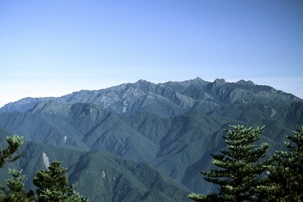
Five Peaks and a Sea of Clouds
Hikers approach Yu Shan along trails that wind through forests of camphor and cypress before breaking into alpine meadows and bare rock. The mountain has five main peaks: the Main Peak at 3,952 meters, the Eastern Peak at 3,869 meters, and the Western Peak at 3,467 meters, among others. For international peak-baggers, Yu Shan ranks as the fourth-highest island summit in the world and the third-highest in Asia. Some climbers combine it with Puncak Jaya in Indonesia and Mount Kinabalu in Malaysia to complete an 'Asian Trilogy.' The signature experience of the climb is the sea of clouds that fills the valleys below, turning the surrounding peaks into islands floating in white. Snow covers the summit from November through March, falling an average of 24 days per year - though that number is gradually decreasing.
A Contested Symbol
In 1966, a large bronze statue of the calligrapher and politician Yu Youren was placed on Yu Shan's summit by the Republic of China government. Thirty years later, in 1996, activists for Taiwan independence cut it down and threw it into a ravine - a symbolic rejection of the mainland Chinese identity the statue represented. Today, Yu Shan has become central to a different kind of identity. Its image on the NT$1,000 banknote, issued on 20 July 2005, declares the mountain a national symbol. An asteroid discovered by the Lulin Observatory at National Central University on 28 December 2007 was named Yushan in honor of the peak. The mountain no longer belongs to any colonial power. It belongs to Taiwan, as Taiwan decides what that means.
From the Air
Located at 23.47N, 120.96E in central Taiwan. Yu Shan (3,952m / 12,966ft) is the highest peak in Taiwan and the dominant terrain feature of the Central Mountain Range. The summit is the centerpiece of Yushan National Park (103,121 hectares). CRITICAL: Maintain safe altitude - terrain rises abruptly above 3,000m. Weather conditions are highly variable, with cloud cover common below the summit and severe conditions in winter. The Yushan weather station sits on the north peak at 3,858m. Nearest airports: Chiayi Airport (RCKU) to the west, Taichung (RCMQ) to the northwest. The mountain is visible from considerable distance on clear days, appearing as the highest point of the ridgeline. Snow cover visible November through March.