Yugansky Nature Reserve
Sixty-four percent of the Yugansky Nature Reserve is covered by forest. The remaining thirty-six percent is swamp. That ratio tells you everything about this place: a vast, waterlogged wilderness in the basin of the Bolshoy Yugan River where the land cannot decide whether it wants to be solid ground or open water. Established in 1982 as a zapovednik, Russia's strictest category of nature protection, Yugansky sprawls across 648,636 hectares of the West Siberian Plain in the Khanty-Mansi Autonomous Okrug. It lies roughly 500 kilometers north of Omsk and 300 kilometers south of the nearest city, Surgut. Getting here requires effort. Staying requires permission. The land itself seems to prefer it that way.
A Landscape Between Water and Earth
The terrain of Yugansky occupies the southern Sredneobskaya lowlands, where narrow river valleys thread between enormous expanses of bog. The Bolshoy Yugan River, a left tributary of the Ob, serves as the reserve's central artery, its floodplains supporting forests of spruce mixed with Siberian cedar and fir. Prevailing winds blow from the southwest and south, carrying moisture that feeds the already saturated ground. The frost-free season lasts just 92 days on average, with a growing period of 137 days. For much of the year, the landscape exists in shades of white and gray, the frozen bogs stretching to the horizon under low Siberian skies. In summer, the same terrain becomes an impassable maze of standing water, mosquito clouds, and knee-deep sphagnum moss.
The Animals That Remain
Yugansky shelters 40 species of mammals, though more than half are rodents scurrying through the understory. The larger residents command attention: brown bears emerge from winter dens to fish the spring floods, lynx stalk through the spruce shadows, and wolverines range across territories that can span the entire reserve. Elk and forest reindeer represent the herbivore contingent, moving between seasonal feeding grounds along routes that predate human settlement in the region. The reserve's isolation is its greatest asset for wildlife. With no roads cutting through the interior and no settlements within its boundaries, the animals of Yugansky experience something increasingly rare on Earth: a landscape where human presence is genuinely absent rather than merely reduced.
Closed by Design
A zapovednik is not a national park. The distinction matters. Where national parks balance conservation with public access, zapovedniks prioritize ecological protection with an almost monastic severity. Yugansky is mostly closed to the general public. Scientists may arrange visits through park management, as can those with approved environmental education purposes, but casual tourism is not accommodated. The reserve maintains a small nature museum in the village of Ugut, where its main office is located, and has opened a single ecotourist route through one of its marsh zones, available by advance arrangement. Beyond that, Yugansky has embraced digital outreach, conducting most of its educational activities through online and virtual media. The remoteness that once limited the reserve's reach has become, paradoxically, its brand.
The Value of Inaccessibility
Three hundred kilometers from the nearest city and far from any convenient transportation, Yugansky exists in a kind of geographic quarantine. This isolation serves a scientific purpose: the reserve functions as a baseline, a control group against which the ecological damage of Western Siberia's oil industry can be measured. The surrounding Khanty-Mansi Autonomous Okrug is one of Russia's most productive petroleum regions, its landscape scarred by pipelines, well pads, and access roads. Yugansky offers a window into what this territory looked like before extraction began, a living reference point for what the taiga and wetlands can sustain when left alone. In a region where the ground itself is valued primarily for what lies beneath it, the reserve makes the quiet argument that the surface matters too.
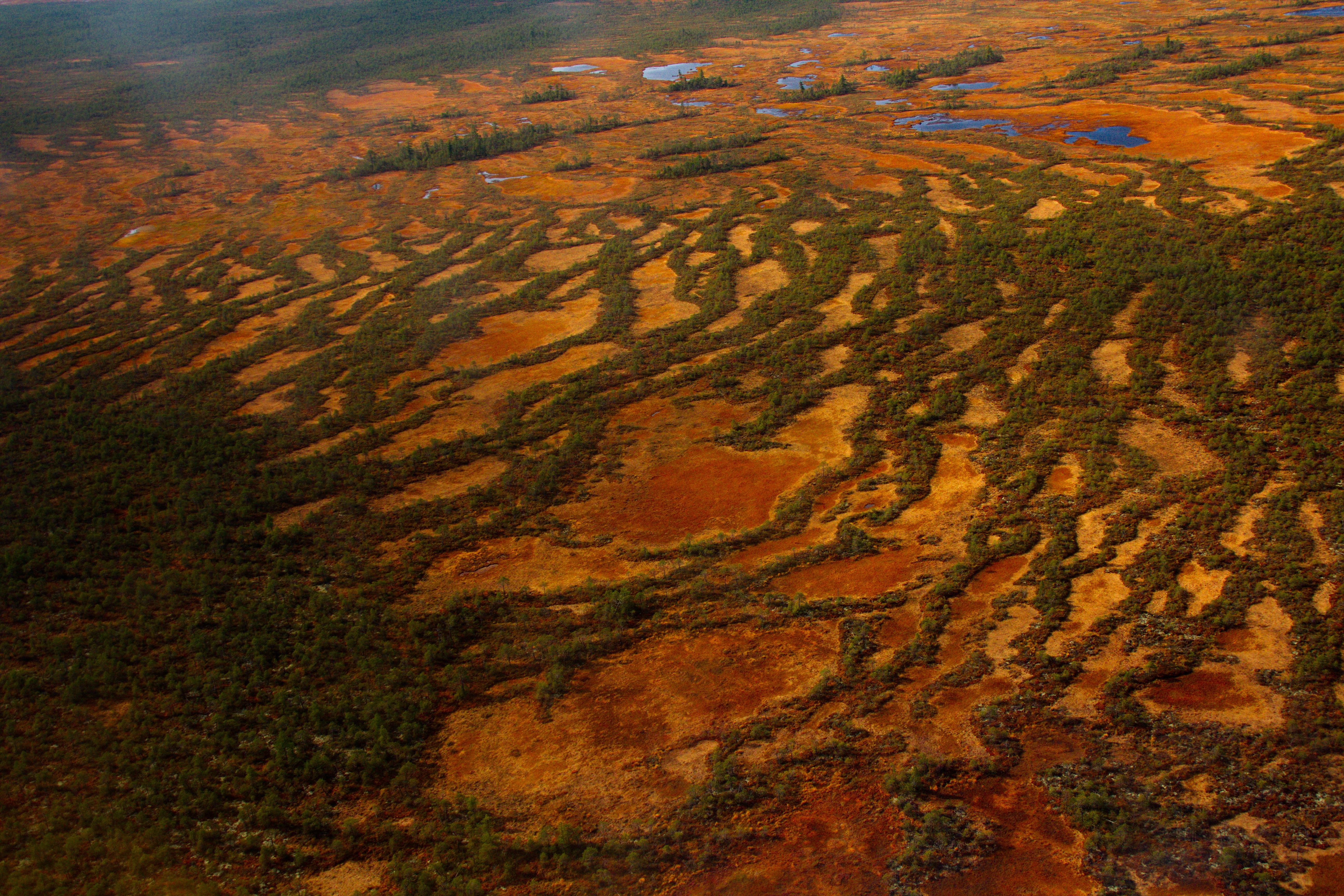
From the Air
Located at 59.66N, 74.63E in the basin of the Bolshoy Yugan River, a tributary of the Ob, in the Khanty-Mansi Autonomous Okrug. The reserve covers 648,636 hectares of bog and taiga. Best viewed at 20,000-30,000 ft where the vast wetland mosaic becomes visible. Nearest city is Surgut (USRR), approximately 300 km to the north. Khanty-Mansiysk (USHH) lies to the northwest. From altitude, the boundary between the intact reserve and surrounding petroleum infrastructure is starkly visible.