Zaculeu
The name means "white earth" -- saq for white, ulew for earth -- in three languages at once: Mam, K'iche', and Q'anjob'al. Zaculeu sits on a narrow plateau overlooking the Selegua River in the western Guatemalan highlands, about 3.7 kilometers from the modern city of Huehuetenango, at an altitude of 1,900 meters in the shadow of the Sierra de los Cuchumatanes. Deep ravines guard its south and east flanks. The only way in is a thin land bridge from the north. This geography made it a natural fortress, and the Mam people used it as exactly that -- a last refuge during the Spanish conquest of 1525 that ended in one of the most harrowing sieges in Mesoamerican history.
Two Kingdoms in One City
Occupation at Zaculeu dates to the Early Classic period, between AD 250 and 600, when most of its 43 structures were built in a single burst of construction. The city served as the capital of the Mam kingdom until the K'iche' of Q'umarkaj conquered it, layering their own architectural traditions over the existing layout. The result is a site where two styles fuse visibly. The typical Mam settlement ran along a southeast-to-northwest axis; the K'iche' imposed their own pattern, centered on a westward-facing temple with a steep talud-tablero facade, flanked by unequal wings -- likely the temple of Awilix, patron goddess of the Nija'ib' K'iche' lineage. Because the K'iche' did not demolish the earlier buildings, they built around them, and the juxtaposition of Mam and K'iche' complexes across Zaculeu's eight plazas tells the story of a conquered people whose architecture their conquerors chose to absorb rather than erase.
The Siege of Kayb'il B'alam
When the Spanish arrived, the main Mam population lived in Xinabahul -- now Huehuetenango. They retreated to Zaculeu's natural fortifications as the invaders advanced. In 1525, Gonzalo de Alvarado y Contreras, brother of the more famous Pedro de Alvarado, attacked with 120 Spanish soldiers and some 2,000 Mexican and K'iche' allies. The city's last ruler, Kayb'il B'alam, held out for months. The siege was a war of starvation. When the Spanish finally entered Zaculeu, they found 1,800 dead, with the surviving defenders eating the corpses of the fallen. Kayb'il B'alam surrendered -- not to superior force in battle, but to hunger. The siege's brutality stands as a stark record of what conquest meant for the people who endured it: not a single heroic moment of defeat, but months of slow, desperate attrition.
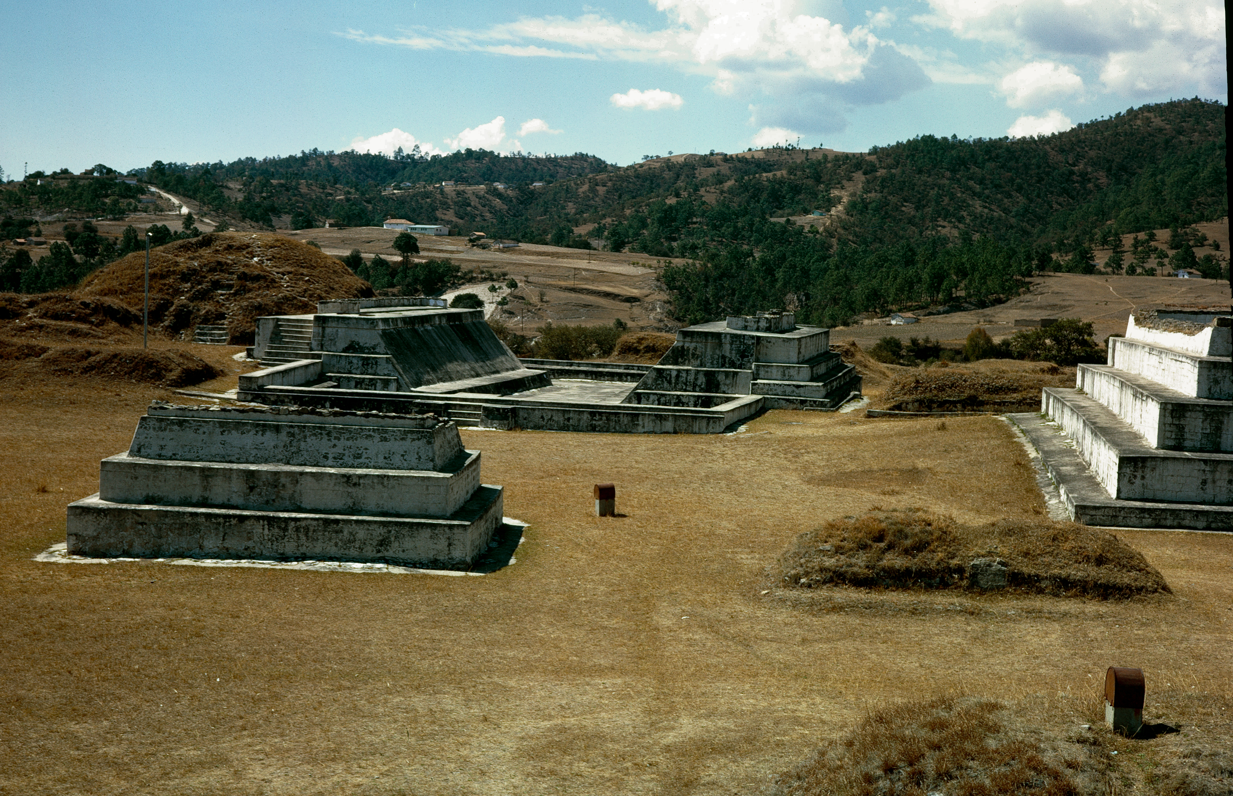
Pyramids, Plazas, and a Ballcourt
Zaculeu's ceremonial center packs 43 structures into just 4 hectares (about 10 acres). Pyramid temples, palace buildings with internal chambers and benches, and a 48-meter I-shaped ballcourt with sloping walls are grouped around a series of plazas. Plaza 1, the main public space, measures 54 meters across, enclosed on all four sides by pyramids. Structure 6 rises in stepped sections topped by a summit shrine, accessible by a stairway that splits in two near the top. Burials from the Early Classic yielded rich offerings -- earthenware bowls with duck effigies, obsidian knives, jade beads, and fragments of gold were found in a tomb at Structure 4. Later burials contained fewer grave goods, suggesting a decline in wealth over time. The architecture lacks stone sculpture entirely, an unusual absence for a Maya site, and no evidence of corbel vaulting has been found. What remains is defined by mass and arrangement: platforms, stairs, and open spaces designed for ceremony and governance.
White Plaster and the United Fruit Company
Guatemala declared Zaculeu a National Monument on April 24, 1931, and in the 1940s the United Fruit Company funded excavations and restorations. American archaeologist Richard B. Woodbury participated in the work, reporting progress in academic journals. The restoration team made an unusual decision: they re-coated several buildings with white plaster, reproducing the finish that originally gave the site its name. This is rarely done at pre-Columbian sites, where exposed stone is usually the preferred aesthetic of modern preservation. The white plaster has drawn criticism from some visitors and scholars who find it jarring, but it is arguably more historically honest than bare masonry that the builders never intended to show. On June 12, 1970, the site was further designated a National Precolumbian Monument by the Guatemalan Ministry of Education. Today Zaculeu sits quietly outside Huehuetenango, its white-coated pyramids bright against the green highland valley -- a fortress whose greatest battle left no victors.
From the Air
Located at 15.33N, 91.49W in the western Guatemalan highlands, approximately 3.7 km west of Huehuetenango at 1,900 meters elevation. The site occupies a plateau overlooking the Selegua River, with the Sierra de los Cuchumatanes mountain range visible to the north. From altitude, the plateau and its narrow land-bridge access are clearly distinguishable. The nearest airfield is Huehuetenango Airport (MGHT). The whitewashed pyramids may be visible in clear conditions as bright spots against the surrounding vegetation.