
Aesepus Bridge
Eight kilometers north of the village of Sarıköy, at the point where the Gönen Çayı valley narrows before opening into the wide estuary plain near the Sea of Marmara, two granite pier stubs protrude from the river's current. They are what remains of the Aesepus Bridge — called in Turkish the Güvercin Köprüsü, or Dove Bridge — a late Roman or early Byzantine structure that once carried a major road across the river Aesepus (the ancient name for the Gönen Çayı) on the way to the coastal city of Cyzicus. When the British archaeologist Frederick Hasluck examined the bridge in the early 20th century, the four main vaults had already collapsed, but nearly all the piers and seven minor arches were still intact. Now, the condition of anything above the waterline is hard to assess. What is certain is that the engineering was sophisticated enough to survive, in fragmentary form, for somewhere between 1,600 and 1,700 years.
A Road to Cyzicus
The Aesepus Bridge existed to serve a specific imperial route. The Roman road it carried crossed Mysia toward Cyzicus, the great port city on the southern shore of the Propontis that served as one of the region's major commercial and military centers. The road retained its original Roman paving — small round stones, 13 to 15 centimeters deep — well enough that by the 19th century it was still the preferred route for travelers moving between nearby Bandırma (then known as Panderma) and the interior settlement of Boghashehr. That kind of durability says something about how well Roman road crews built in this region. The bridge itself sat approximately 5.6 kilometers upstream from where the Gönen Çayı enters the Sea of Marmara, just above the transition point where the narrow valley gives way to the flat estuary plain. A modern highway bridge on route 200 now carries traffic across the same river a short distance away — the ancient and modern lines of travel running close but not coinciding, each representing the engineering priorities of its era.
The Hollow-Chamber Innovation
What makes the Aesepus Bridge technically interesting is its hollow-chamber pier system. The exposed upper portions of the piers contained four parallel slot-like spaces running the full length of each pier — hollow channels designed to reduce the load pressing down on the vaults below. This approach to weight reduction was not unique to this bridge: Hasluck identified the same system in three other Mysian bridges of apparent similar date — the White Bridge, the Makestos Bridge, and Constantine's Bridge. The piers themselves were protected against river current by large cutwaters with pointed caps on both the upstream and downstream sides. The outer facing of the structure, including the breakwaters and the hollow chambers, was built of granite blocks; the interior was filled with mortar-bound rubble. The roadway surface that survives on the remaining portion rests on the roof slabs of the hollow chambers, a construction sequence that integrated the structural and civil engineering elements into a single coherent system.
Roman Foundation or Byzantine Rebuilding?
When exactly the bridge was built — and when it was rebuilt — has been a matter of scholarly debate. Hasluck, examining the structure in 1906, noted its similarities with the other hollow-chamber bridges in Mysia and attributed the whole group to the early 4th century AD, placing construction in the reign of Constantine the Great, who died in 337 AD and who elevated Byzantium to the capital of the eastern empire. The Italian scholar Galliazzo argued for a different reading. The characteristic pattern of alternating brick and stone layers in the arch construction pointed, in his view, to an early Byzantine rebuilding in the second half of the 5th or the early 6th century — the period of Justinian's extensive building campaigns. Galliazzo's position was that only the pier foundations and the lower abutments with their minor arches were unambiguously Roman; the upper elements represented later reconstruction work. Both views agree that the structure spans the transition between late Roman and early Byzantine imperial administration, a period when Mysia was firmly integrated into the eastern empire and road maintenance remained a state priority.
What the Excavation Found
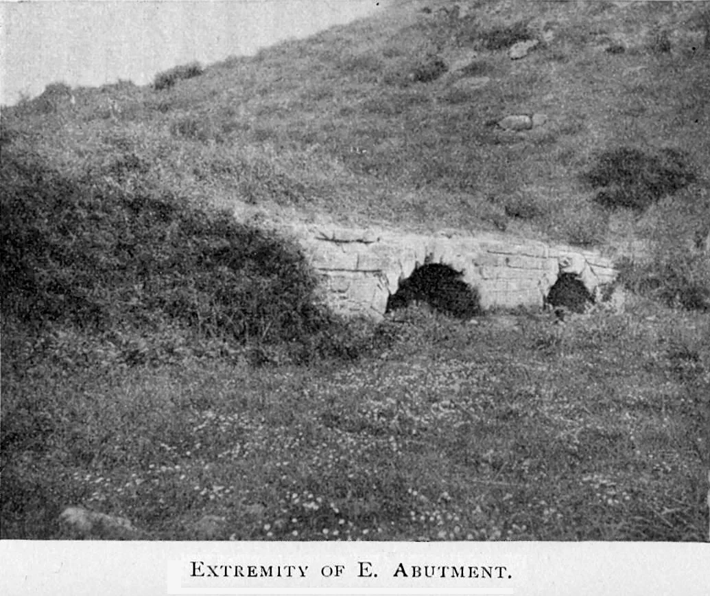
At the western approach, the abutment is short because the Gönen Çayı runs close to the valley's western slope at this point. The western abutment's two arch vaults were built of brick, with the outer voussoirs — the wedge-shaped stones that form the arch — alternating between stone and brick groups in the same manner found at the Makestos Bridge. The 58-meter-long eastern ramp rests on five arches of diminishing size; the ninth arch in the sequence was so overgrown at the time of Hasluck's survey that he could only reconstruct its position conjecturally. At the eastern approach, the remains of a semicircular exedra in brick mark the point where the road forks — a feature also found at the Sangarius Bridge in Bithynia, suggesting a design convention for major road junctions on important imperial routes. Next to the exedra stands an 80-centimeter cylindrical stone column that may have recorded repairs to the bridge over the centuries: a maintenance log in stone, though whatever inscriptions it bore have not been reported in detail. The two pier stubs still visible in the river today are the most tangible survivors of a structure that once tied this valley into the imperial road network of the eastern Mediterranean.
From the Air
The Aesepus Bridge site lies at 40.267°N, 27.602°E, in the Gönen Çayı valley approximately 8 km north of Sarıköy and 5.6 km upstream from the river's mouth at the Sea of Marmara. At 1,500–3,000 feet MSL, the river valley and the point where it opens into the estuary plain are clearly visible; the bridge pier stubs are best seen in low-water conditions. The nearest airport is LTBG (Bandırma Airport), approximately 40 km to the north-northwest. The modern highway 200 bridge crossing, visible nearby, provides an easy reference point for locating the ancient bridge site slightly upstream. The surrounding landscape is flat river-plain agriculture — wheat fields and rice paddies between Sarıköy to the south and the Marmara coast to the north.
Nearby Stories
- Marmara Island 2 km away
- Çimpe Castle 6.6 km away
- Parium 8.3 km away
- 1953 Yenice–Gönen Earthquake 8.7 km away
- 2025 Istanbul Earthquake 27 km away
- Mount Ida (Turkey) 46 km away
- Battle of Melantias 75 km away
- Palace of the Grand Master of the Knights of Rhodes 404 km away