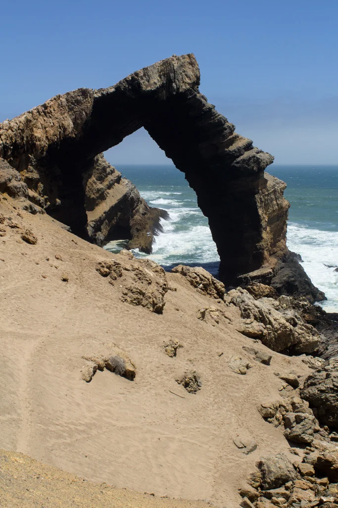

Bogenfels
Reaching Bogenfels is harder than reaching almost any other landmark in Africa, and that is precisely why it survives untouched. The arch sits inside the Sperrgebiet, the "forbidden zone," a stretch of Namibian coast sealed off for diamond mining since 1908 and patrolled to keep out anyone without a permit. Get past the checkpoints, drive the trackless gravel plains south of Lüderitz, and the desert suddenly drops away into the sea, where a 55-metre span of grey rock arcs over the breaking waves like a doorway built for giants. The German name says it plainly: Bogenfels, the arch rock.
A Doorway of Dolomite
The arch is a quarrel between two kinds of stone. Its bones are dolomite, hard and pale, laid down in marine layers across an almost unimaginable span of time and shot through with bands of softer shale. The Atlantic has spent millennia picking at the weak seams, hollowing out the shale and leaving the dolomite to bridge the gap, until what remains is a freestanding span rising 55 metres from the waterline. Stand beneath it as the swell rolls through and the whole formation seems to hum. There is no quiet here. The cold Benguela current drives surf against the cliff in an endless percussion, and spray hangs in the wind off a coast that sailors once called the most dangerous in the world.
Diamonds in the Sand
This emptiness is an illusion of value, not the absence of it. In 1908 a railway worker stooped to pick a glittering stone from the sand near Lüderitz, and within months the German colonial authorities had fenced off the entire region as the Sperrgebiet. The diamonds here were not dug from deep mines but scattered loose across the desert floor, carried by ancient rivers and sorted by the wind, so abundant in places that early prospectors were said to crawl on hands and knees gathering them by lamplight. To protect that fortune, the colony drew a line on the map and forbade all entry. More than a century later the line still holds, which is why the coast around Bogenfels remains one of the least-trodden places on the continent.
The Ghost at Pomona
Thirty-two kilometres up the coast lies the corpse of a town. Pomona was founded in 1912 at the height of the diamond frenzy, and at its peak around five hundred people lived there in the dunes, building not just mine works but villas, a school, a doctor's house, even a bowling alley, a startling little outpost of European comfort in one of the driest deserts on Earth. A private narrow-gauge electric railway, completed in 1913, ran 119 kilometres through Pomona to the mining hub of Kolmanskop, powered by a station back in Lüderitz. The line lasted barely two years. South African troops tore it up in 1915 during the First World War, and the desert began its slow reclamation. By 1950 the settlement at Bogenfels itself was evacuated and abandoned to the sand, a ghost town ever since.
Permission to Enter
For most of a century, almost no one saw the arch. The Sperrgebiet kept its secret behind locked gates and the threat of arrest, and that long enforced solitude preserved both the landscape and its silence. Today a narrow door has opened: official guided tours, run under strict permit out of Lüderitz, carry small groups across the restricted zone to stand in the arch's shadow and walk the bones of Pomona. The rules remain severe, the access tightly controlled, the desert as indifferent as ever. But that is the bargain Bogenfels offers. The same prohibition that made it nearly impossible to reach is the reason it still feels like the edge of the known world.
From the Air
Bogenfels stands on the Namib coast at 27.46°S, 15.39°E, about 95 km south of Lüderitz and 32 km south of the Pomona ghost town, inside the restricted Sperrgebiet (Tsau-Khaeb National Park). From the air the arch reads as a distinctive notch where a dolomite headland meets the Atlantic surf line; the cold Benguela current often brings coastal fog, so clear-weather windows are best. The contrast between the white desert plain and the dark wet rock makes the formation easiest to pick out in low morning or late-afternoon light. Nearest airfield is Lüderitz Airport (FYLZ) to the north; Keetmanshoop (FYKT) lies farther inland to the east. Recommended viewing altitude 1,500 to 4,000 ft AGL along the coastline, conditions permitting. Note the entire zone is sensitive restricted airspace and access on the ground requires a permit.
Nearby Stories
- Roter Kamm Crater 54 km away
- Kolmanskop 61 km away
- Aus, Namibia 78 km away
- Bom Jesus (ship) 89 km away
- Oranjemund 141 km away
- Eduard Bohlen 363 km away
- Sandwich Harbour 462 km away
- Cospatrick 1058 km away