Where the Bird's Body Begins
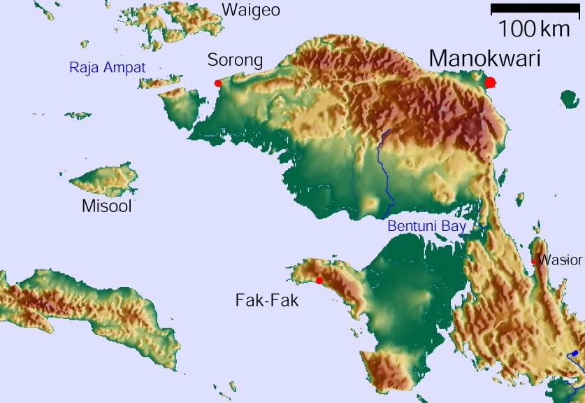
Cartographers have always struggled with New Guinea. The island's western half resolves, on any map, into the shape of a bird in flight - the Bird's Head Peninsula reaching northwest, the long tail stretching east toward Papua New Guinea. But tucked beneath the head, separated by the wide waters of Bintuni Bay, sits a landmass that rarely appears in travel guides or documentary films. The Bomberai Peninsula is the bird's chest - a dense, marshy, rainforest-covered expanse of land where more than a dozen languages are spoken, where rainbow fish swim in limestone caves, and where seven centuries of recorded contact with the outside world have barely altered the landscape.
Feathers for Empires
Long before any European ship rounded the peninsula's coast, the Bomberai was already connected to a trade network that stretched across Southeast Asia. As early as the 7th century, the Sriwijaya Empire - centered in Sumatra, thousands of kilometers to the west - traded for birds of paradise feathers harvested from these forests. The plumes were luxury goods, prized in courts from Java to China. By the 14th century, the Majapahit Empire's court poet recorded the names "Wanin" and "Sran" in the Nagarakretagama manuscript, references that scholars believe point to the Onin Peninsula and the Kowiai kingdom on Bomberai's southern coast. If correct, these are the earliest written mentions of any Papuan place names - evidence that this remote peninsula was anything but isolated, even in the medieval world.
Forts and Fevers
The first European to sight these shores was the Spanish navigator Luis Vaz de Torres in 1606, threading through the strait that would bear his name. Over the following centuries, the Sultanate of Tidore - a small but ambitious spice island power - extended its influence over the region under the legendary figure Gurabesi. When the Dutch arrived to formalize colonial claims, they built Fort Du Bus on Triton Bay in 1828, appointing three local rulers to govern on behalf of the Netherlands. The arrangement was elegant on paper and miserable in practice. Malaria ravaged the garrison, and attacks from the surrounding population made the fort untenable. By 1835, the Dutch abandoned it. They would not seriously attempt to govern the Bomberai again until the turn of the 20th century, when administrative posts were established at Fakfak in 1898. Even then, actual control remained thin, delegated through layers of local kings and regional rulers whose authority predated any European presence by centuries.
A Babel of the Tropics
What makes the Bomberai Peninsula extraordinary, even by New Guinea's standards, is its linguistic density. More than a dozen languages are spoken across its forests and coastal villages, drawn from at least five unrelated language families. The Central-Eastern Malayo-Polynesian family contributes Irarutu, Kowiai, Onin, and Sekar, among others. The West Bomberai languages Baham and Iha form their own branch. Asmat-Kamoro languages Buruwai and Kamberau are spoken in parts of the interior. And then there are the isolates - Mor and Tanah Merah - languages that belong to no known family at all, their origins lost in a past too deep for historical linguistics to reach. On Karas Island, just off the western coast, the Karas language persists among a small community. Each of these languages carries its own cosmology, its own way of naming the rivers and ridges of a peninsula that, from the air, looks uniformly green.
Rainforest and Reef
Dense tropical rainforest covers nearly the entire peninsula, most of it lowland marsh forest stretching across a flat, waterlogged plain. Along the western edge, the Fakfak Mountains rise to 1,619 meters, cloaked in montane forest where the air cools and the canopy thins. The Kumawa Mountains to the southeast push toward the Arafura Sea, their southern slopes almost entirely unexplored by outsiders. In the karst limestone formations that riddle both mountain ranges, freshwater streams harbor extraordinary biodiversity. Twenty-four endemic species of rainbow fish - genus Melanotaenia - live in the waters of the Bird's Head and Bomberai region, including the Harlequin Rainbow Fish, whose males flash bands of orange and blue iridescence. The Fakfak Mountains shelter the black-eared catbird and Oninia senglaubi, a narrow-mouthed frog found nowhere else on Earth. Marine conservation efforts led by Konservasi Indonesia have established protected areas along the coast, where coral reefs fringe the same bays that once harbored spice traders.
The View from Above
From altitude, the Bomberai resolves into a puzzle of green and blue - the unbroken canopy of the lowlands, the darker ridgelines of the Fakfak and Kumawa ranges, and the intricate coastline where bays fold into the land like fingers. Bintuni Bay opens to the north, a wide expanse of shallow water separating the peninsula from the Bird's Head. To the south, Kamrau Bay carves inland, and the narrow land bridges that connect the Bomberai to the rest of New Guinea are barely visible, thin strips of green between vast bodies of water. The town of Fakfak, the peninsula's only real settlement with port facilities, sits on the northwestern coast where the Onin Peninsula juts into the Seram Sea. Beyond it, the land stretches east into territory that remains, even now, among the least visited on the planet - a place where the forest still holds more authority than any map.
From the Air
Centered at approximately 3.16°S, 133.17°E, the Bomberai Peninsula occupies the area south of New Guinea's Bird's Head. The Fakfak Mountains (peak 1,619 m / 5,312 ft) along the western edge are the most prominent visual feature from altitude. The town of Fakfak on the northwest coast has the nearest airport - Torea Airport (FKQ). Kaimana, on the southeastern coast, is served by Utarom Airport (KNG). Bintuni Bay to the north and Kamrau Bay to the east create clear water boundaries visible from cruising altitude. The peninsula is almost entirely forested with few clearings - look for the contrast between the dark green canopy and the turquoise shallows of the surrounding bays and reef systems.
Nearby Stories
- One Stove, Three Stones 31 km away
- The Captain's Old Habits 34 km away
- The Gamble Beneath Bintuni Bay 42 km away
- Seven Years of Fever and Flag 95 km away
- The Lake People's Living Palette 176 km away
- Cenderawasih Bay 196 km away
- The Throat of the Bird 213 km away
- The Abyss That Isn't a Trench 288 km away